Sold2021EXCEPTIONAL 1859 MAP OF ORANGE/ROCKLAND COUNTIESEXCEPTIONAL 1859 MAP OF ORANGE/ROCKLAND COUNTIES, FF FRENCH, WE WOOD & S.N. BEERS PUB. CORY & BACHMAN, 65" X 62"See Sold Price
Sold20211829 BURR MAP ORANGE & ROCKLAND COUNTYHand-colored engraving. Dimensions: (Frame) H 26.75" x W 29.75", (Sight) H 18" x W 21.25" Condition: Map with center fold as published. Scattered staining and light foxing. Frame with marks.See Sold Price
Sold2020Antique 1859 Map of Kendall County IllinoisBy L. J. Bennett, 45 x 51 inches some damageSee Sold Price
Sold202319th Cent. Clark Litchfield County Map Dated 185919th Cent. Clark Litchfield County Map Dated 1859 40" x 56" including the frame, appears to be trimmedSee Sold Price
Sold20241859 Clark & Hopkins Wall Map Litchfield County CTAntique 1859 Clark & Hopkins Topographical Wall Map of Litchfield County Connecticut, Coated Fabric Backed Paper with Original Rollers. Measures 55 inches x 51 inches. Please note condition issues notSee Sold Price
Sold20231859 Map of Connecticut by ColtonTitle: 1859 Map of Connecticut by Colton Date/Period: 1859 Materials: Steel engraved Size: 17 1/2 x 14 1/2” Connecticut. Shows, rivers, lakes, counties cities, towns, villages, roads, and rail lSee Sold Price
Sold2017Map, Orange and Rockland Counties New York 1859From actual Surveys by F.F. French W.F Wood & S.N. Beers, Corey & Bachman Publishers. 6'1"w x 5'7"lSee Sold Price
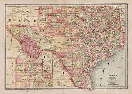
Sold20221885 Two-page Railroad map of TexasCram’s 1885 double-page railroad map of Texas has exceptional printed color. Every railroad line in the state is highlighted in a heavier black line than such things as county borders, rivers anSee Sold Price
Sold2023United States of North America, Pacific States by Joseph Wilson Lowry 1859 mapDescriptionCAPTION PRINTED BELOW PICTURE: The United States of North America, Pacific States [including California, Oregon, Washington, Utah, and part of New Mexico, ]The map shows Washington, Oregon,See Sold Price
Sold2022Exceptional map of Johnson's Texas, 1866Authentic and impressive vintage map of Texas. A highly desirable map that details the state in full. Shows the elevated Table Lands, the U. S. Mail Route, the Staked Plain (El Llando Estadado), numerSee Sold Price
20231859 Map of Texas. By ColtonTitle: 1859 Map of Texas. By Colton Date/Period: 1859 Materials: Hand colored steering engraved Size: 17 1/2 x 14 1/2” br>Texas right before the civil war, inserts the northern part of the stateSee Sold Price
Sold20231859 Map of Texas. By ColtonDescriptionTitle: 1859 Map of Texas. By ColtonDate/Period: 1859Materials: Hand colored steering engravedSize: 17 1/2 x 14 1/2”br>Texas right before the civil war, inserts the northern part of thSee Sold Price
Sold20221859 MAP OF MANHATTAN (FASCIMILE OF 1664) 21 X 271859 MAP OF MANHATTAN (FASCIMILE OF 1664) 21 X 27See Sold Price
20231859 Map of Florida by ColtonTitle: 1859 Map of Florida by Colton Date/Period: 1859 Materials: Steel engraved Size: 17 1/2 x 14 1/2” Florida with Florida keys in the insert. From before the civil war. By J. H. Colton & G. WSee Sold Price
Sold2023Burmah, Siam & Anam. Indochina Shan States Thailand Vietnam. WELLER 1859 mapCAPTION PRINTED BELOW PICTURE: 'Burmah, Siam, and Anam' DATE PRINTED: 1859 IMAGE SIZE: Approx 37.0 x 27.0cm, 14.5 x 10.75 inches (Large) TYPE: Antique engraved atlas map with original hand colour/coloSee Sold Price
Sold2023New Zealand Sandwich Galapagos Islands. Papuan Archipelago. Melanesia 1859 mapNew Zealand. // Sandwich Islands, or Hawaiian Group, // Galapagos Islands // Papuan Archipelago' by John Bartholomew (1859). Antique engraved atlas map with original hand colour/color, 37.0 x 53.5cm,See Sold Price
Sold20231859 Map of Florida by ColtonTitle: 1859 Map of Florida by Colton1859 Materials: Steel engraved Size: 17 1/2 x 14 1/2” Florida with Florida keys in the insert. From before the civil war. By J. H. Colton & G. W. Colton. From "GeSee Sold Price
Sold20211859 Map of New Amsterdam, (Manhattan) AS IS. 30" X 24"1859 MAP OF New Amsterdam (Manhattan)AS IS. 30" X 24". This map is actually a rendering after a 1664 map made in 1859.See Sold Price
Sold20231859 Map of Washington and Oregon territory includes modern Idaho by ColtonTitle: 1859 Map of Washington and Oregon territory includes modern Idaho by Colton Date/Period: 1859 Materials: Steel engraved Size: 17 1/2 x 14 1/2” Washington and Oregon territories with whatSee Sold Price
Sold20231859 Map of Boston and surrounding communities by ColtonTitle: 1859 Map of Boston and surrounding communities by Colton Date/Period: 1859 Materials: Steel engraved Size: 17 1/2 x 14 1/2” br>Boston and surrounding communities. Shows, rivers, lakes, coSee Sold Price
Sold2023An 1860 Map, Counties of New York, New Hampshire, Etc...Hand colored lithograph, by Samuel Augustus Mitchell (1790-1868). :County Map of the States of New York, New Hampshire, Vermont, Massachusetts, Rhode Island and Connecticut". Dimensions:15 1/2" x 23 1See Sold Price
Sold20231859 Map of Massachusetts and Rhode Island. Insert of Boston by ColtonTitle: 1859 Map of Massachusetts and Rhode Island. Insert of Boston by Colton1859 Materials: Steel engraved Size: 17 1/2 x 14 1/2” Massachusetts and Rhode Island. With insert of Boston and surroundiSee Sold Price
Sold20211859 Map of the USTitle: 1859 Map of the US Author: Chambers Medium: Ink on Paper Dimensions: 11.5"X9.5" Description: Map of the United States dated 1859. Part of the Modern & Ancient Geography Atlas. Engraved by J.GelSee Sold Price
Sold20211859 Map of PalestineTitle: 1859 Map of Palestine Author: Chambers Medium: Ink on Paper Dimensions: 9.5"X11.5" Description: Map of Palestine dated 1859. Part of the Modern & Ancient Geography Atlas. Engraved by J.GellatlySee Sold Price
3 days LeftTemplum Fine Art AuctionsHistory of Colonial Mexico - Viceroyalty of New Spain - Large and Very Rare Exceptional Map of New€1,000
3 days LeftJasper52Leeward Islands. Cuba, Hayti/Haiti or Santo Domingo, Puerto Rico. LOWRY 1859 map$110
3 days LeftJasper52Windward or South Caribbean Islands. Barbados St. Lucia. Guianas. LOWRY 1859 map$60
Jul 06Case Antiques, Inc. Auctions & Appraisals5 TVA Map Books incl. Tennessee & New York c. 1935-1950$250
2 days LeftJasper521865 Colton Map of US Southwest -- Colton's Map of California, Nevada, Utah, Colorado, Arizona & New$160
Jul 11Copley Fine Art AuctionsExceptional Miniature Hissing Goose by Joseph W. Lincoln (1859-1938)$1,500
3 days LeftJasper52JAMAICA. Counties/parishes. Sugar Mill & Kingston views. RAPKIN/TALLIS 1851 map$85
3 days LeftJasper52JAMAICA. Counties/parishes. Sugar Mill & Kingston views. RAPKIN/TALLIS 1851 map$85
3 days LeftJasper52Jamaica. Kingston Port Royal Bluefields/Savanna-la-Mar inset. THOMSON 1830 map$100
2 days LeftLiberty & 33rd Furniture Co.Antique Victorian Walnut Architect's Blueprint Flat File Cabinet or Collector's Cabinet$800
Jul 06Case Antiques, Inc. Auctions & AppraisalsJohn Adams Elder O/C 1859 Virginia Portrait, Lizzie Holladay$350(1 bid)
85 Lots AwaySchilb Antiquarian Rare BooksUS War w/ SPAIN 1898 1ed Puerto Rico CUBA Philippines MAPS Russell Illustrated$185(4 bids)


![United States of North America, Pacific States by Joseph Wilson Lowry 1859 map: DescriptionCAPTION PRINTED BELOW PICTURE: The United States of North America, Pacific States [including California, Oregon, Washington, Utah, and part of New Mexico, ]The map shows Washington, Oregon,](https://p1.liveauctioneers.com/5584/311630/167410815_1_x.jpg?height=310&quality=70&version=1701439692)


