Sold20221859 MAP OF MANHATTAN (FASCIMILE OF 1664) 21 X 271859 MAP OF MANHATTAN (FASCIMILE OF 1664) 21 X 27See Sold Price
Sold20211664 / 1859 "The Duke's Plan" A Description ofBy: original cartographer unknown / Reissue by: David Thomas Valentine / Engraved by: George HaywardDate: original manuscript 1664 / Reissue 1859 (Published) New YorkDimensions: 21.75 x 27.25 inches (See Sold Price
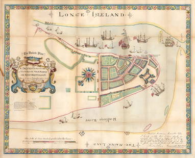
Sold2016Map of Manhattan, Hand-Colored PrintMap of Manhattan "Longe Isle Land", "A Description of the Towne of Mannados, or New Amsterdam, 1664". [Art: 25 1/2" x 31 1/2"; Frame: 27" x 33"]. Frame has no glass, staining and some foxing. From theSee Sold Price
Sold20211859 Map of New Amsterdam, (Manhattan) AS IS. 30" X 24"1859 MAP OF New Amsterdam (Manhattan)AS IS. 30" X 24". This map is actually a rendering after a 1664 map made in 1859.See Sold Price
Sold2023CYPRUS HONG KONG TOKYO PEKING JERUSALEM. City plans. Anzhu islands 1900 mapCyprus, Hong Kong, Wrangel & Anjou Is. environs of Tokio, Peking & Jerusalem' by W. & A.K. Johnston, Limited, Edinburgh & London (1900). Antique colour map, 21.0 x 27.0cm, 8.25 x 10.5 inches Details:See Sold Price
Sold2023ANTIQUE HAND TINTED MAP OF FRANCEFRAMED HAND TINTED MAP OF FRANCE, DATED 1792. CREASES AND FOLDS. 27" x 21" MAP SIZE / 31" x 25" IN FRAME.See Sold Price
Sold2018AMERICAN - INDIA NOVA Vintage Hand Colored Map FramedAMERICAN - INDIA NOVA Vintage Hand Colored Map Framed.Size: 21.5 x 27.5 edge of frameSee Sold Price
Sold2015Period 18th Century Map of Switzerland.Period 18th century map of Switzerland. By A. Rouvier. 21" x 27-1/2" plate size. Published by John Rocque 1760, London. Size 29 -1/2" x 21 -1/4".See Sold Price
Sold2023CYPRUS HONG KONG TOKYO PEKING JERUSALEM. City plans. Anzhu islands 1899 mapCyprus, Hong Kong, Wrangel and Anjou Island, environs of Tokio, Pekin, and Jerusalem' by W. & A.K. Johnston (1899). Colour antique map, 27.0 x 21.0cm, 10.5 x 8.25 inches Details: TITLE/CONTENT OF MAP:See Sold Price
Sold2016Map of Colorado, 1895Title: Map of Colorado Original engraving from "Atlas of the World" by Rand McNally Date: 1895 Dimensions: 21 x 27 1/2 inches Description: Map includes counties, geographical landmarks, streets and poSee Sold Price
Sold2023SOUTH AMERICA. Bolivia includes Acre, now in Brazil. JOHNSTON 1899 old mapTitle: SOUTH AMERICA. Bolivia includes Acre, now in Brazil. JOHNSTON 1899 old map Description: South America, political' by W. & A.K. Johnston (1899). Colour antique map, 27.0 x 21.0cm, 10.5 x 8.25 inSee Sold Price
Sold2023Burmah, Siam & Anam. Indochina Shan States Thailand Vietnam. WELLER 1859 mapCAPTION PRINTED BELOW PICTURE: 'Burmah, Siam, and Anam' DATE PRINTED: 1859 IMAGE SIZE: Approx 37.0 x 27.0cm, 14.5 x 10.75 inches (Large) TYPE: Antique engraved atlas map with original hand colour/coloSee Sold Price
Sold2018Earnest Dudley Chase, "America the Wonderland" MapEarnest Dudley Chase (1878-1966) America the Wonderland map - 1941, including dozens of vignettes of buildings around the US Signed on lower left "E. Dudley Chase" Approx. 21" x 27.5"See Sold Price
Sold20191760 Kitchin Map of Durham England -- An Accurate MapTitle: 1760 Kitchin Map of Durham England -- An Accurate Map of the County Palatine of Durham Date: 1760 c London Medium: T. Kitchin Size: 21 x 27 in. Additional Information: A very visually impactfulSee Sold Price
Sold20211892 Southbridge Map with American Optical,Dresser House Stables, C.A. Dresser Hotel, Etc. - See pictures for staining & some paper loss - 21" x 27" Framed - Walnut Frame- See Photos for ConditionSee Sold Price
2022Blaeu, Johannes (Netherlands, 1596-1673) "The New World Map" Double Hemisphere World Map C. 1664Nova et Accuratissima Totius Terrarum Orbis Tabula Translated "The New World Map", Hand Colored w/ Elaborately Decorated Spandrels.   Sight View 16" x 21-1/2", Overall View 21" x 25-1/2"See Sold Price
Sold2021Antique French Map of MississippiAntique French Map of Mississippi , "Carte Geographique, Statistique et Historique du Mississipi", Paris, Buchon, 1825, sight 21 in. x 27 1/2 in., framed Provenance: Estate of Julia Evans ReedSee Sold Price
Sold2024Europe exhibiting its principal states &c. First French Empire. FADEN 1791 mapTITLE/CONTENT OF MAP: 'Europe exhibiting its principal states &c' DATE PRINTED: 1791 IMAGE SIZE: Approx 54.5 x 69.5cm, 21.5 x 27.25 inches (Large); Please note that this is a folding map. TYPE: LargeSee Sold Price
Sold2024Carved Wood World Map ArtNorth America measures 21" H x 27" W. Approx. 1" D off the wall.See Sold Price
Sold2019FRENCH MAP OF THE WORLD 1778Hand colored engraving in two hemispheres with decorative surround. Descriptions to left and right on separate sheets glued down. Dimensions: (Frame) H 21" x W 27", (Sight) H 13" x W 20" Condition: CrSee Sold Price
Sold2021Antique Engraved Map of Chester, EnglandAn antique hand colored map of the County of Chester, England. By Eman. Bowen. Framed under glass. Mat opening: 21 in x 27-1/2 in. Some light toning and spotting.See Sold Price
Sold2018FLORIDA. State map. Shows Miami. Railroads. JOHNSTONTITLE/CONTENT OF MAP: 'Florida' DATE PRINTED: 1906 IMAGE SIZE: Approx 21.5 x 27.0cm, 8.5 x 10.5 inches (Medium) TYPE: Antique colour map CONDITION: Good; suitable for framing. However, please note: ThSee Sold Price
Sold20231795 Map of South American by Mathew Carey, Philadelphia16.5 x 21.5 inches, sight. Framed, 21.5 x 27 inches. Condition reports are not available for the items in this catalog. These are antique and vintage items, and will show signs of use and wear. We havSee Sold Price
Sold2017Hans Pinggera (born 1900) German O/CHans Pinggera (born 1900) German O/C, Signed Lower-Left, Image - 17'' H x 22'' L, Frame - 21'' H x 27'' L (from private collection of Manhattan collector, purchased over 40 years ago)See Sold Price
4 days LeftJasper52Leeward Islands. Cuba, Hayti/Haiti or Santo Domingo, Puerto Rico. LOWRY 1859 map$100
May 16Potter & Potter Auctions[NEW YORK CITY – PICTORIAL MAPS]. Group of 3 pictorial maps...$200(1 bid)
May 22Concept Art GalleryPablo Picasso Linoleum Cuts 1962 Bacchanals, Women, Bulls and Bullfighters$125(1 bid)
May 24Eldred'sPETER BUSA (Pennsylvania, 1914-1985), Untitled abstract., Mixed media on paper laid on board, 18" x$150
May 24Eldred'sPAINTING OF A MAN AND HIS HORSE AT A RIVER Mid-20th Century Oil on board, 17" x 23" sight. Framed$50


![Map of Manhattan, Hand-Colored Print: Map of Manhattan "Longe Isle Land", "A Description of the Towne of Mannados, or New Amsterdam, 1664". [Art: 25 1/2" x 31 1/2"; Frame: 27" x 33"]. Frame has no glass, staining and some foxing. From the](https://p1.liveauctioneers.com/1221/84975/43771795_1_x.jpg?height=310&quality=70&version=1455055180)


![[NEW YORK CITY – PICTORIAL MAPS]. Group of 3 pictorial maps... (1 of 3)](https://p1.liveauctioneers.com/928/325952/175495562_1_x.jpg?height=282&quality=70&version=1712935174)


