Sold20211859 Map of PalestineTitle: 1859 Map of Palestine Author: Chambers Medium: Ink on Paper Dimensions: 9.5"X11.5" Description: Map of Palestine dated 1859. Part of the Modern & Ancient Geography Atlas. Engraved by J.GellatlySee Sold Price
Sold2021Dussieux, Louis 1859 Mixed Lot of 8 MapsIncl France, Germany, Palestine, Greece, Denmark, Spain and Portugal. Steel Engraved Maps Published 1859, Paris for "Atlas Complet de Geographie Elementaire" by Louis Dussieux. Centre fold as publisheSee Sold Price
Sold2021EXCEPTIONAL 1859 MAP OF ORANGE/ROCKLAND COUNTIESEXCEPTIONAL 1859 MAP OF ORANGE/ROCKLAND COUNTIES, FF FRENCH, WE WOOD & S.N. BEERS PUB. CORY & BACHMAN, 65" X 62"See Sold Price
Sold2023United States of North America, Pacific States by Joseph Wilson Lowry 1859 mapDescriptionCAPTION PRINTED BELOW PICTURE: The United States of North America, Pacific States [including California, Oregon, Washington, Utah, and part of New Mexico, ]The map shows Washington, Oregon,See Sold Price
20231859 Map of Texas. By ColtonTitle: 1859 Map of Texas. By Colton Date/Period: 1859 Materials: Hand colored steering engraved Size: 17 1/2 x 14 1/2” br>Texas right before the civil war, inserts the northern part of the stateSee Sold Price
Sold20231859 Map of Texas. By ColtonDescriptionTitle: 1859 Map of Texas. By ColtonDate/Period: 1859Materials: Hand colored steering engravedSize: 17 1/2 x 14 1/2”br>Texas right before the civil war, inserts the northern part of thSee Sold Price
Sold20221859 MAP OF MANHATTAN (FASCIMILE OF 1664) 21 X 271859 MAP OF MANHATTAN (FASCIMILE OF 1664) 21 X 27See Sold Price
20231859 Map of Florida by ColtonTitle: 1859 Map of Florida by Colton Date/Period: 1859 Materials: Steel engraved Size: 17 1/2 x 14 1/2” Florida with Florida keys in the insert. From before the civil war. By J. H. Colton & G. WSee Sold Price
Sold2023Burmah, Siam & Anam. Indochina Shan States Thailand Vietnam. WELLER 1859 mapCAPTION PRINTED BELOW PICTURE: 'Burmah, Siam, and Anam' DATE PRINTED: 1859 IMAGE SIZE: Approx 37.0 x 27.0cm, 14.5 x 10.75 inches (Large) TYPE: Antique engraved atlas map with original hand colour/coloSee Sold Price
Sold2023New Zealand Sandwich Galapagos Islands. Papuan Archipelago. Melanesia 1859 mapNew Zealand. // Sandwich Islands, or Hawaiian Group, // Galapagos Islands // Papuan Archipelago' by John Bartholomew (1859). Antique engraved atlas map with original hand colour/color, 37.0 x 53.5cm,See Sold Price
Sold20231859 Map of Florida by ColtonTitle: 1859 Map of Florida by Colton1859 Materials: Steel engraved Size: 17 1/2 x 14 1/2” Florida with Florida keys in the insert. From before the civil war. By J. H. Colton & G. W. Colton. From "GeSee Sold Price
Sold20211859 Map of New Amsterdam, (Manhattan) AS IS. 30" X 24"1859 MAP OF New Amsterdam (Manhattan)AS IS. 30" X 24". This map is actually a rendering after a 1664 map made in 1859.See Sold Price
Sold20231859 Map of Washington and Oregon territory includes modern Idaho by ColtonTitle: 1859 Map of Washington and Oregon territory includes modern Idaho by Colton Date/Period: 1859 Materials: Steel engraved Size: 17 1/2 x 14 1/2” Washington and Oregon territories with whatSee Sold Price
Sold20231859 Map of Boston and surrounding communities by ColtonTitle: 1859 Map of Boston and surrounding communities by Colton Date/Period: 1859 Materials: Steel engraved Size: 17 1/2 x 14 1/2” br>Boston and surrounding communities. Shows, rivers, lakes, coSee Sold Price
Sold20231859 Map of Massachusetts and Rhode Island. Insert of Boston by ColtonTitle: 1859 Map of Massachusetts and Rhode Island. Insert of Boston by Colton1859 Materials: Steel engraved Size: 17 1/2 x 14 1/2” Massachusetts and Rhode Island. With insert of Boston and surroundiSee Sold Price
Sold2020Antique 1859 Map of Kendall County IllinoisBy L. J. Bennett, 45 x 51 inches some damageSee Sold Price
Sold20231859 Map of Connecticut by ColtonTitle: 1859 Map of Connecticut by Colton Date/Period: 1859 Materials: Steel engraved Size: 17 1/2 x 14 1/2” Connecticut. Shows, rivers, lakes, counties cities, towns, villages, roads, and rail lSee Sold Price
Sold20211859 Map of the USTitle: 1859 Map of the US Author: Chambers Medium: Ink on Paper Dimensions: 11.5"X9.5" Description: Map of the United States dated 1859. Part of the Modern & Ancient Geography Atlas. Engraved by J.GelSee Sold Price
Sold20231859 Map of Illinois, with Chicago, insert by ColtonTitle: 1859 Map of Illinois, with Chicago, insert by Colton Date/Period: 1859 Materials: Steel engraved Size: 17 1/2 x 14 1/2” Illinois with an insert of Chicago. By J. H. Colton & G. W. Colton.See Sold Price
Sold20211859 Map of CanadaTitle: 1859 Map of Canada Author: Chambers Medium: Ink on paper Dimensions: 11.5"X9.5" Description: Map of Canada dated 1859. Part of the Modern & Ancient Geography Atlas. Engraved by J.Gellatly. PublSee Sold Price
Sold20201859 Map of MexicoTitle: 1859 Map of Mexico Author: Johnson Medium: Ink on Paper Dimensions: 18"x14" Map of Mexico dated 1859. Engraved by A.J. Johnson. Published by Johnson and Ward in New York. Johnson is consideredSee Sold Price
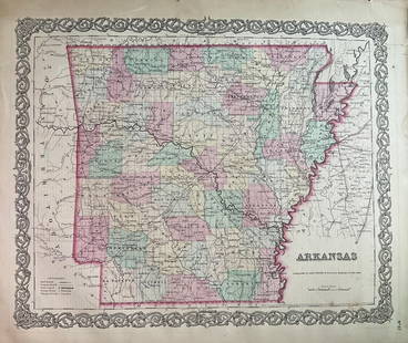
Sold20231859 Map of Arkansas by ColtonTitle: 1859 Map of Arkansas by Colton Date/Period: 1859 Materials: Steel engravedSize: 17 1/2 x 14 1/2” Arkansas. From before the civil war. By J. H. Colton & G. W. Colton. From "General Atlas".See Sold Price
Sold20201859 Map of Washington state, Oregon and IdahoAuthor: Johnson Title: 1859 Map of Washington state, Oregon and Idaho Medium: Ink on Paper Dimensions: 18"X14.5" Map of Washington state and Oregon dated 1859. Engraved by A.J. Johnson. Published by JSee Sold Price
Sold20211859 Map of Ancient GreeceTitle: 1859 Map of Ancient Greece Author: Chambers Medium: Ink on Paper Dimensions: 9.5"X11.5" Description: Map of Ancient Greece dated 1859. Part of the Modern & Ancient Geography Atlas. Engraved bySee Sold Price
4 days LeftJasper52Windward or South Caribbean Islands. Barbados St. Lucia. Guianas. LOWRY 1859 map$60
4 days LeftJasper52Leeward Islands. Cuba, Hayti/Haiti or Santo Domingo, Puerto Rico. LOWRY 1859 map$100
May 12Schilb Antiquarian Rare Books1859 AFRICA VOYAGES Barth Timbuktu Tripoli SLAVES Illustrated Slavery MAP African$62(4 bids)
May 14Fleischer's Auctions1755 Map Partie de l'Amerique Septentrionale, qui comprend Le Cours de L'Ohio...$200(3 bids)
23 hrs LeftTremont AuctionsJohn Speed and Francis Lamb "Map of New England and New York", ca. 1676. Hand colored engraved map$900(3 bids)
23 hrs LeftTremont Auctions17th century original map 1676 "Virginia and Maryland" by John Speed. 2 sided framing. Overall:$650(3 bids)
May 12Schilb Antiquarian Rare Books1859 BEAUTIFUL BINDING Underground World Geology Volcanoes CAVES Coal Fossils$56(2 bids)
7 days LeftCrescent City Auction GalleryWilliam H. Williams (1817-1886), New Orleans "Map of the Sixth District and Carrollton," 1871, H.-$650


![United States of North America, Pacific States by Joseph Wilson Lowry 1859 map: DescriptionCAPTION PRINTED BELOW PICTURE: The United States of North America, Pacific States [including California, Oregon, Washington, Utah, and part of New Mexico, ]The map shows Washington, Oregon,](https://p1.liveauctioneers.com/5584/311630/167410815_1_x.jpg?height=310&quality=70&version=1701439692)