Sold20241880 Large Atlas Map of Palestine IsraelA large map of Palestine from an Atlas published by A and C Black at Edinburgh circa 1880. Fine condition, measures 13 x 17.5". Reserve: $50.00 Shipping: Domestic: Flat-rate of $10.00 to anywhere withSee Sold Price
Sold20165 large maps5 large maps including A Modern Pilgrim's The British Isles; Round About The Nation's Capital; Africa and the Arabian Peninsula; c. 1966 Newburgh, NY. 1965 map of Israel. Tears; foxing; creases. 30 inSee Sold Price
Sold2017MAP, C. 1750, INDIA & SOUTHEAST ASIA, ISAAK TIRIONFramed map of India an nearby countries, "Nieuwe Kaart van India over de Ganges of van Malakka, Siam, Cambodia, Chiampa, Kochinchina, Laos, Pegu, Ava" c. 1750 by Issak Tirion (Dutch, 1705-1765), handSee Sold Price
Sold2022Bowen, Emanuel Collection of engraved maps, c.1750-65Bowen, Emanuel Collection of engraved maps, c.1750-65 including: A New and Accurate Map of China; A New and Accurate Map of the Empire of Japan; Turky in Asia, Arabia, etc.; A New and Accurate Map ofSee Sold Price
Sold2018Scull: Antique Map of North America, 1812Title/Content of Map: North America. Date Printed: 1812 Cartographer: SCULL, WILLIAM ? Size (inches): 19.75x27.5 "From Arrowsmith's large map &c. W.S. sc." Please note that this lot has a confidentialSee Sold Price
Sold2016Antique Framed Map of Israel, C. 1748.Ivdaea Sev Palaestina, ... Terra Sancta. By Johann Baptist Homann. Framed, 18.5" x 21.5" sight size. Visible foxing. From a Larchmont NY estate. Dimensions: 23" w x 20" h framed. Condition: Foxing, noSee Sold Price
Sold2022Dorotheenthaler Large Stag c.1750 Faience SteinFaience Stein 1L Dorotheenthaler Factory. Large stag. Circa 1750.See Sold Price
Sold2022Pluche, Noel C1750 HC Map. Lapland, Norway, Poland etc"The Navigation of the North" Copper Engraved Map Published C1750, London for "Spectacle de la Nature: or Nature Display'd" by Noel Antoine Pluche. Paper Size: 8 x 5 inch (20 x 13cm) Very minor marginSee Sold Price
Sold2023Calmet, Augustin 1732 Large Map. Old Jerusalem, Israel, Holy Land"A Description of Old Jerusalem according to Villalpandus" Folio Copper Plate Published 1732, London for "An Historical, Critical, Geographical, Chronological and Etymological Dictionary of the Holy BSee Sold Price
202316th c. Map, Israel, Middle East - TRIBUS ASER by Christian van AdrichomDescription16th c. Engraved Map of Israel, Middle East - TRIBUS ASER [Territory of the Tribe of Asher in the Holy Land] by Christiaan van Adrichem, (1533-1585) and Arnold Mylius (1540-1604) | PublisheSee Sold Price
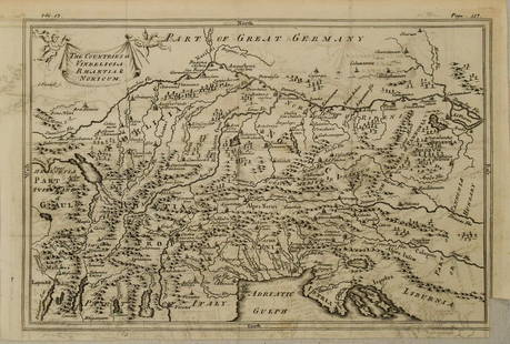
Sold20201750 c. Map of Eastern Alps Region in Ancient Times --Title: 1750 c. Map of Eastern Alps Region in Ancient Times -- The Countries of Vindelicia, Rhaethia & Noricum Cartographer: G Sale et al Year/Place: 1750 c., London Size: 7.8 X 11.8 in. Additional InfSee Sold Price
Sold2023Calmet, Augustin 1732 Large Map. Children of Israel. Arabia Egypt Holy Land"A Map of the Children of Israel's Travels and Marches in the Wilderness from their going out of Egypt..." Folio Copper Plate Published 1732, London for "An Historical, Critical, Geographical, ChronolSee Sold Price
Sold2023Sale & Psalmanazar C1750 Map. Mavretania, Numidia, Gaetulia &c. N. AfricaCopper Plate Published 1747-68, London for "An Universal history, from the earliest account of time..." by George Sale, George Psalmanazar et al. Paper Size: 12.5 x 9 inch (32 x 23cm) Very minor toninSee Sold Price
Sold2019Turkey C1750 Large Prints. Dancing DervishesFolio Copper Plate Published C1750, Europe. Unknow Artist/Engraver and publication. Paper Size: 16 x 12 inch (40 x 30cm) Some wrinkles, browning/toning/staining. Small bottom margin tear.See Sold Price
Sold2023Sale & Psalmanazar C1750 Map. Pannonia Moesia Davia and Illyricum Turkey GreeceCopper Plate Published 1747-68, London for "An Universal history, from the earliest account of time..." by George Sale, George Psalmanazar et al. Paper Size: 12.5 x 8 inch (32 x 20cm) Good ConditionSee Sold Price
Sold2023Sale & Psalmanazar C1750 Map. Retreat of the ten thousand Greeks XenophonCopper Plate Published 1747-68, London for "An Universal history, from the earliest account of time..." by George Sale, George Psalmanazar et al. Paper Size: 12.5 x 9 inch (32 x 23cm) Good ConditionSee Sold Price
Sold2023Sale & Psalmanazar C1750 Map. The Countries of Vindelicia, Rhaetia & NoricumCopper Engraved Map Published 1747-68, London for "An Universal history, from the earliest account of time..." by George Sale, George Psalmanazar et al. Paper Size: 12.5 x 8 inch (32 x 20cm) Good CondSee Sold Price
Sold2023Sale & Psalmanazar C1750 Map. Syria after ye death of Alexander the GreatCopper Plate Published 1747-68, London for "An Universal history, from the earliest account of time..." by George Sale, George Psalmanazar et al. Paper Size: 12.5 x 8.5 inch (32 x 22cm) Good ConditionSee Sold Price
Sold2023Sale & Psalmanazar C1750 Map. Arabia Petraea and DesertaCopper Plate Published 1747-68, London for "An Universal history, from the earliest account of time..." by George Sale, George Psalmanazar et al. Paper Size: 13 x 8.5 inch (33 x 22cm) Some text offsetSee Sold Price
Sold2023Sale & Psalmanazar C1750 Map. Indelicia, Rhaetia & Noricum"The Countries of Vindelicia, Rhaetia & Noricum" Copper Plate Published 1747-68, London for "An Universal history, from the earliest account of time..." by George Sale, George Psalmanazar et al. PaperSee Sold Price
Sold2023Sale & Psalmanazar C1750 Map. Libya interior, Garamantum et MelanogaetulorumCopper Plate Published 1747-68, London for "An Universal history, from the earliest account of time..." by George Sale, George Psalmanazar et al. Paper Size: 13 x 9.5 inch (33 x 24cm) Very minor offseSee Sold Price
Sold20201750 Bellin Map of Maldive Islandsc1750 map of the Maldive Islands by Jacques Bellin, printed at Paris. Very Good, edge wear, measures 7 x 9.5". Reserve: $30.00 Shipping: Domestic: Flat-rate of $5.00 to anywhere within the contiguousSee Sold Price
Sold20201750 c. Schenk Map of Eastern Germany Centered onTitle: 1750 c. Schenk Map of Eastern Germany Centered on Dresden -- Dem Durchlauchtigsten Fursten und Herrn Herrn Friedrich Augusto... Cartographer: P Schenk II Year/Place: 1750 c., Amsterdam Size: 19See Sold Price
Sold2021ROBERT DE VAUGONDY MAP OF SOUTH AMERICA, C. 1750Robert de Vaugondy (French, 1686-1766). "Amerique Meridionale" -1750, engraving with hand coloring. Approx. 20" x 24.75' (sheet)See Sold Price
Jul 07Mark Louis Weseloh Estate LiquidationsOriginal 16th c. Map of Paris - L’isle de France - Parisiensis Agri de Scrip. 21” x 16&#$300
2 days LeftGalerie Zacke A CANTON ENAMEL 'ANTIQUE TREASURES' DISH, ANBAXIAN, QIANLONG MARK AND PERIOD€800
2 days LeftA.H. Wilkens Auctions & AppraisalsJEFFERYS. AN EXACT CHART OF THE RIVER ST. LAURENCECA$200(1 bid)
2 hrs LeftJasper521653 Blaeau Map of the Dnieper River -- Lectori S. Hunc Borysthenis Tractum ut ad Nostrum$850
3 days LeftLeland LittleEmanuel Bowen (English, 1697-1767), Map of the American Southeast$100(2 bids)
Jul 03Jasper52Northern States of Europe… Denmark Norway Sweden Russia Prussia. PAAS 1800 map$70


![16th c. Map, Israel, Middle East - TRIBUS ASER by Christian van Adrichom: Description16th c. Engraved Map of Israel, Middle East - TRIBUS ASER [Territory of the Tribe of Asher in the Holy Land] by Christiaan van Adrichem, (1533-1585) and Arnold Mylius (1540-1604) | Publishe](https://p1.liveauctioneers.com/6084/291748/157234438_1_x.jpg?height=310&quality=70&version=1689539413)