Sold2018Miniature Atlas of Brooklyn 2 vols. 1912Heading: (New York - Brooklyn) Author: Hyde, E. Belcher Title: Miniature Atlas of the Borough of Brooklyn Place Published: Brooklyn, NY Publisher:E. Belcher Hyde Date Published: 1912 DeSee Sold Price
Sold2022THREE HAND-COLORED MAPS OF ASIATHREE HAND-COLORED MAPS OF ASIA1) “Asia”, from a miniature Ortelius atlas, Brescia, after 1598. 3.75” x 5” sight. Framed 9” x 10.5”.2) “A New Map of Asia̶See Sold Price
Sold2022New atlas of universal geography in 52 cardsMilan, Batelli and Fanfani, [1820]. In 2nd. Unnumbered plate with armillary sphere, 50 numbered geographical maps of which many large folded, all in fine period coloring, missing the front door with tSee Sold Price
Sold2020Miniature atlas of Europe 1762Heading: Author: Rizzi-Zannoni, Giovanni Antonio Title: Atlas geographique contenant la Mappemonde et les quatre Parties avec les differents Etats d'Europe... Place Published: Paris Publisher:Chez LaSee Sold Price
Sold2022British Isles.- Duncan (James) [A New Atlas of England and Wales; Consisting of a set of largeNO RESERVE British Isles.- Duncan (James) [A New Atlas of England and Wales; Consisting of a set of large County Travelling Maps], without title, but with double-page table and 44 double-page engravedSee Sold Price
Sold20211830 "A New Atlas World" Educational School Map Book1830 "A New Atlas World"Antique Educational School Maps. This is a wonderful antique atlas for early education, geography classes. It has a layout of the world and the breakdown of each continent. BecSee Sold Price
Sold2022Approx 1000 New Miniature Doll Diapers and Ashton DrakeApproximately 1000 new miniature doll diapers for reborning or dressing 5"-6" dolls and Ashton Drake Heavenly Handfuls Handful of Love Miniature 5" Baby Doll NIB Lob . Mini diapers made toSee Sold Price
Sold2022NEW ATLAS OF THE WORLD, WILNER, © 1919, MATTHEWSNEW ATLAS OF THE WORLD, WILNER, © 1919, MATTHEWS. Hardcover, no dustcover, NEW YORK CHRISTIAN HERALD publishers. Note, bound volume loose from covers, but fits in nicely. Approximate measurements:See Sold Price
Sold2023NEW! MINIATURE 4 PIECE CAR SET-NEW MINIATURE 4 PIECE CAR SET -COCA COLA 1927 FORD ROADSTER, 1933 FORD SEDAN DELIVERY, 1964 WW TYPE2 PICKUP, 1959 CHEVY IMPALA-B1See Sold Price
Sold2021Lot of new miniature toys, Disney, Keepsake & moreLot of new miniature toys, Disney, Keepsake and moreSee Sold Price
Sold2023SAMUEL DUNN NEW ATLAS MAP ENGRAVINGS LOT OF 5The North Part of Italy Comprehending the Dominions of the King of Sardinia, the Estates of Parma & Modena of Genoa, Venice and Lucca & Spain and Portugal with Their General Divisions & The Northern SSee Sold Price
Sold2023NEW! MINIATURE JOHN DEERE 2010 CRAWLER-NEW MINIATURE JOHN DEERE 2010 CRAWLER -B1See Sold Price
Sold2023NEW! MINIATURE JOHN DEERE 2010 CRAWLER-NEW MINIATURE JOHN DEERE 2010 CRAWLER -B1See Sold Price
Sold2023NEW! MINIATURE JOHN DEERE 2010 CRAWLER-NEW MINIATURE JOHN DEERE 2010 CRAWLER -B1See Sold Price
Sold2023NEW! MINIATURE 4 PIECE CAR SET-NEW! MINIATURE 4 PIECE CAR SET -COCA COLA INTERNATIONAL COLLECTION-B1See Sold Price
Sold2023NEW! MINIATURE JOHN DEERE 2010 CRAWLER-NEW MINIATURE JOHN DEERE 2010 CRAWLER -B1See Sold Price
Sold2020Rare marketing atlas for Los Angles at mid-centuryHeading: (California - Los Angeles) Author: Title: Los Angeles Marketing Atlas: A new atlas for Los Angeles City and County showing: Shopping Centers, Industrial Areas, Census Tract Boundaries, CommuSee Sold Price
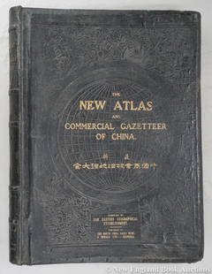
Sold2023Dingle, Edwin John51. Dingle, Edwin John. The New Atlas and Commercial Gazetteer of China. 28 color-printed maps and 18 color-printed statistical tables. Large folio, publisher's black cloth decorated in gilt and blindSee Sold Price
Sold2018Sketch of Fort Brewerton, at the West End of OnedaReserve Reduced! Title: Sketch of Fort Brewerton, at the West End of Oneda Lake. Date: c1796 Cartographer: ANONYMOUS Size (inches): 4.75X6 Plate 49 from a rare miniature atlas of forts in America. OldSee Sold Price
Sold2015Cary's New Universal Atlas,Containing Distinct Maps of All the Principal States and Kingdoms, etc., London: Printed for J. Cary, Engraver, 1811, with 56 double-page engraved hand-colored maps on 60 numbered sheets (complete), rSee Sold Price
Featured6 days LeftJasper52Mitchell’s Map of Asia showing travel routes London, India, China & Japan, 1860$45
6 days LeftJasper521869 Mitchell Map of Much of Western Europe -- XXXII Prussia the German States Holland & Belgium$30
23 hrs LeftHunt and Peck Estate Services, Inc.Abraham Ortelius map of Bitiurigum from Theatrum Orbis Terrarum$50


![New atlas of universal geography in 52 cards: Milan, Batelli and Fanfani, [1820]. In 2nd. Unnumbered plate with armillary sphere, 50 numbered geographical maps of which many large folded, all in fine period coloring, missing the front door with t](https://p1.liveauctioneers.com/3796/250546/130126095_1_x.jpg?height=310&quality=70&version=1654521704)

![British Isles.- Duncan (James) [A New Atlas of England and Wales; Consisting of a set of large: NO RESERVE British Isles.- Duncan (James) [A New Atlas of England and Wales; Consisting of a set of large County Travelling Maps], without title, but with double-page table and 44 double-page engraved](https://p1.liveauctioneers.com/5458/255060/132669289_1_x.jpg?height=310&quality=70&version=1657897192)