Sold2022Vintage County Maps of Texas Topography Maps TexasThese are vintage maps that were first made in 1915 and 1921. These maps are a great glance into the early official mapping of the Americas. The two maps in this lot are of Texas. (1) Topography map oSee Sold Price
Sold2022Vintage Maps of Texas CountiesBound vintage book containing maps of Texas counties, featuring maps based off early twentieth century cartography 1.5"h x 17"w x 14"d We happily provide seamless shipping services on everything weSee Sold Price
Sold2019AN VINTAGE MAP, "Texas and Indian Territory," SECONDAN VINTAGE MAP, "Texas and Indian Territory," SECOND QUARTER 20TH CENTURY, color engraving on paper, showing counties, cities, rail lines, and rivers. 13.25" x 10.125"See Sold Price
Sold20231866 Schönberg's Early Map of Texas Historic Vintage Inspired Map1866 Schönberg's Early Map of Texas Historic Vintage Inspired Map As settlers spread west, Schönberg's map of Texas shows the growing state of Texas and the contemporary counties as ofSee Sold Price
Sold20221866 Schönberg's Early Map of Texas Historic Vintage Inspired Map1866 Schönberg's Early Map of Texas Historic Vintage Inspired Map As settlers spread west, Schönberg's map of Texas shows the growing state of Texas and the contemporary counties as ofSee Sold Price
Sold2017Colton: Antique Map of Texas, 18641860 Colton’s Texas - uncommon. From an 1864 school atlas. This map is not seen very often. Delineates all counties to 1860. Shows topography, forts, railroads, battle fields, rivers, etc. �See Sold Price
Sold2023Collection of Vintage Texas Maps & SurveysLarge collection of miscellaneous maps and surveys, largely relating to Texas, to include some oil examples We happily provide seamless shipping services on everything we sell. Please email us at shiSee Sold Price
Sold2021Vintage Texas MapVintage map of Texas, framed frame: 17 x 19" Condition: Foxing Provenance: The collection of former CIA Director R. James Woosley & Nancye Miller (San Antonio, Texas) We happily provide seamleSee Sold Price
Sold2021Set 8 of School Charts - Texas History and ResourcesSet 8 of Vintage School Charts Maps - Texas History and Resources36 in tall x 45 x 1 - Denoyer - Geppert of Chicago / J. L Clark & Lewis W. NewtonSee Sold Price
Sold2017Mitchell: Antique County Map of Texas, 1873Excellent 1873 County Map of Texas by S. Augustus Mitchell. Impressive two-page County Map of the State of Texas. Map image much larger than earlier Mitchell maps. Designed and engraved by W. H. GamblSee Sold Price
Sold2018County Map of Texas.Reserve Reduced! Title: County Map of Texas. Publication Date: 1861 Cartographer: MITCHELL, SAMUEL AUGUSTUS (JR.) Publisher: S. Augustus Mitchell, Jr. Size: 10.75 X 13.25 Map 29 from Mitchell's New GeSee Sold Price
Sold2018County Map of Texas.Title/Content of Map: County Map of Texas. Date Printed: 1870 Cartographer: MITCHELL, SAMUEL AUGUSTUS (JR.) Material/Medium: S. Augustus Mitchell, Jr. Size: 9.25X12 Inset of Galveston Bay and VicinitySee Sold Price
Sold2017Mitchell: County Map of Texas, 1862County Map of Texas, S. Augustus Mitchell, 1862. 10.75 x 13.375 inches. Steel engraved map, with hand colored wash and outlines. Inset map of Galveston Bay, and Vicinity. Colored by county and territoSee Sold Price
Sold2018County Map of Texas, S. A. Mitchell, 1860Reserve Reduced! Authentic handcolored map of Texas with 1860 date but from Mitchell’s New General Atlas published 1864 by S. Augustus Mitchell. Detailed early map of Texas, immediately prior to theSee Sold Price
Sold2017Mitchell: Antique County Map of Texas, 1870Map: County Map of Texas Cartographer: S. A. Mitchell Place & Date: Philadelphia / 1870 Size: 13 1/4" x 10 3/4" Condition: full color; light overall age toning The beautifully detailed and colored couSee Sold Price
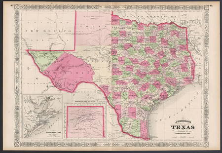
Sold2023Excellent example of Johnson’s Texas, 1866Authentic and impressive vintage map of Texas. One of the more collectible maps to be produced in the mid-19th century. A highly desirable map that details the state in full. Shows the elevated TableSee Sold Price
Sold2021Pair of Texas Maps and CompassPair of bound Texas Bureau of Economic Geology maps, to include "Atlas of Major Texas Oil Reserves" by Galloway and Ewing, "County Maps of Texas" by the State of Texas, compass 17"h x 22"w/ largest PrSee Sold Price
Sold2018Cram Map of TexasCRAM, George F (1842-1928). Railroad and county map of Texas. Lithograph with handcolor, with original black slipcase on the verso. Chicago, 1876. 17 3/4 x 24 inches sheet, 28 x 33 inches framedSee Sold Price
Sold2021Scarce Colton 2-page map of Texas, c1884Breathtakingly large, fully hand-colored vintage map of Texas from the very scarce 1890 edition of Colton’s General Atlas. This is the only edition of this atlas that I’ve ever seen—See Sold Price
Sold2022SAMUEL AUGUSTUS MITCHELL JR., AN AMERICAN CIVIL WAR ERASAMUEL AUGUSTUS MITCHELL JR., AN AMERICAN CIVIL WAR ERA MAP, "County Map of Texas," CIRCA 1863, hand-colored lithograph on paper with profusely floral and fruit border, plate 34. from Mitchell's New GSee Sold Price
Sold2022Exceptional map of Johnson's Texas, 1866Authentic and impressive vintage map of Texas. A highly desirable map that details the state in full. Shows the elevated Table Lands, the U. S. Mail Route, the Staked Plain (El Llando Estadado), numerSee Sold Price
Sold2021Smille, "Military Plaza - San Antonio, Texas†and MapJames Smille and Arthur Schott, titled "Military Plaza - San Antonio Texas”, engraving, to also include a vintage map of Texas, framed frame: 13.5"h x 17"w/ largest Provenance: A San Antonio, TXSee Sold Price
Sold20181876 Mitchell Map of Texas -- County Map of the StateReserve Reduced! Title/Content of Map: 1876 Mitchell Map of Texas -- County Map of the State of Texas Showing also portions of the Adjoining States and Territories Date: 1876 Philadelphia CartographerSee Sold Price
May 16Potter & Potter AuctionsMcCARTY, Lea (1905 – 1960). Sonoma County / Its Highlights ...$100(1 bid)
May 10Rail & Road AuctionsEleven Army Corps of Engineers Port Series No. 1 Through No. 8 Books with Fold Out Maps$35(2 bids)
May 10Rail & Road AuctionsEleven Port Series Books with Fold Out Maps - No. 9 Through No. 23 - Army Corps of Engineers$20(1 bid)
May 16Potter & Potter AuctionsGEESINK, Joop (1913 – 1984). Europa. 1957. Netherlands: KLM...$100