Sold2022MAP, Africa, MercatorFull Contemporary Color. Africa. Gerard Mercator, Africa ex Magna Orbis Terre Descriptione Gerardi Mercatoris Desumpta, Studio & Industria, from Atlas sive Cosmographicae..., 1609 (circa). Hand Color.See Sold Price
Sold2015EUROPAE. [Ortelius, Ca. 1584-1612.] Map.[Ortelius, Abraham] EUROPAE. [C. 1584-1612.] Engraved map by Ortelius based on Jenkinson’s Russia map and Gastaldi’s maps of Africa and Asia, Gerard Mercator’s 1564 map of Britain, a map of ScanSee Sold Price
Sold2020Hondius Map of MoroccoHONDIUS, Jodocus (1563-1612) / MERCATOR, Gerard (1512-1594). [Morocco] Fessae et Marocchi Regna. Engraving with original hand color. Amsterdam, c. 1606 or later. 17 3/4" x 21" sheet. Comparable: Old WSee Sold Price
Sold2022MAP: Gerard Mercator (1512-1594), "Asiae VI. Tab," hand-colored engraving of Ptolemaic map of theMAP: Gerard Mercator (1512-1594), "Asiae VI. Tab," hand-colored engraving of Ptolemaic map of the Middle East, from the 1595 edition of Mercator's Geographia, based upon the works of Claudius PtolemySee Sold Price
Sold2022(LIBYA / TUNISIA.) Gerard Mercator. Africae Tabula Secunda.(LIBYA / TUNISIA.) Gerard Mercator. Africae Tabula Secunda. Double-page engraved Ptolemaic map of the eastern Maghreb region of Africa and the central Mediterranean Sea. 16½x20½ inches sheetSee Sold Price
Sold2023MAP, Africa, MercatorNorthwestern Africa. Mercator/Hondius, Fessae Regnum, from Atlas Minor, 1609 (published). Hand Color. This charming small map of Morocco and Algeria extends south to Beninia and Nussini and includes tSee Sold Price
Sold2017Mercator (Gerard) - Atlas sive Cosmographicae,Editio Quinta, engraved pictorial title, prelims, 49 double-page maps, including Asia, Russia, Turkey, Lithuania, Asia Minor and Persia, regions of Italy Spain, Germany and Eastern Europe, and 11 singSee Sold Price
Sold2018Hondius, Joducius and Mercator, Gerard. Cyprus Ins:from Atlas Sive Cosmographicae, 1619 or somewhat later, copperplate engraving with hand color showing a large map of Cyprus below which are inset maps of Lemnos, Chios, Lesbos, Euboea, Kythera, and RhSee Sold Price
Sold2018Hondius, Joducius and Mercator, Gerard. Cyprus Ins:from Atlas Sive Cosmographicae, 1619 or somewhat later, copperplate engraving with hand color showing a large map of Cyprus below which are inset maps of Lemnos, Chios, Lesbos, Euboea, Kythera, and RhSee Sold Price
Sold2019British Isles.- Mercator (Gerard) & Henricus Hondius.British Isles.- Mercator (Gerard) & Henricus Hondius. Anglia, Scotia et Hibernia, engraving with hand-colouring on laid paper, platemark 340 x 425 mm. (13 1/2 x 16 3/4 in), sheet 445 x 550 mm. (17 1/2See Sold Price
Sold2019Ireland.- Mercator (Gerard) Irlandiae Regnum, on twoIreland.- Mercator (Gerard) Irlandiae Regnum, on two sheets, not joined, showing the north and south of Ireland, engravings with hand-colouring, both on laid paper with indistinct watermarks, each plaSee Sold Price
Sold2018Mercator, Gerard and Hondius, Jodocus. Cypruscopperplate engraving with hand color from Atlas Minor (Dordrecht: Adrianus Bottius, 1610 or later). Presented in a plain wooden frame. DOA 14 x 15.75 in.; SS 6 x 8.25 in. A Single-Owner Collection ofSee Sold Price
Sold2020(MEDITERRANEAN ISLANDS.) Mercator, Gerard; and Hondius,(MEDITERRANEAN ISLANDS.) Mercator, Gerard; and Hondius, Jodocus. Cyprus Ins. Double-page engraved sheet with individual maps of Cyprus, Lemnos, Chios, Lesbos, Euboea, Cythera, and Rhodes. 18x22¾See Sold Price
Sold2022Isle of Man.- North West England.- Mercator (Gerard)Isle of Man.- North West England.- Mercator (Gerard) Westmorlandia, Lancastria, Caernvan, Denbigh, Flint, Merionidh, Dalopia cum issulis Mania et Anglesey, engraving with full hand-colouring, 360 x 41See Sold Price
Sold2022MAP, Africa, MercatorAfrica. Mercator/Jansson, Africae Descriptio, from Atlas Minor, 1630 (published). Hand Color. Fine small map of Africa, which is based largely on the work of Hernicus Hondius and incorporates informatSee Sold Price
Sold202117th C. French Engraving Map of N. Africa MoroccoFrench hand-colored engraving of North Africa, including Morrocco, parts of Algeria, Strait of Gibraltar. Dated 1655. Measures 16"H x 21"W visual image , 23.75"H x 27.75"W framed. Condition report: GoSee Sold Price
Sold20231895 AFRICA Morocco EGYPT Sudan Sierra Leonne Sahara Illustrated MAPS 2v SET1895 AFRICA Morocco EGYPT Sudan Sierra Leonne Sahara Illustrated MAPS 2v SET Augustus Keane was a 19th-century historian and author whose studies in ethnology resonate with even modern day ethnologistSee Sold Price
Sold2022MAP, Africa, MercatorCentral Africa. Mercator/Hondius, Abissinorum Regnu, from Atlas Minor, 1610 (circa). Hand Color. Charming little map with a fair amount of detail along the Horn of Africa, reflecting Colonial tradingSee Sold Price
Sold2020Barbary coat. North west Africa. Morocco, Tunisia,Title: Barbary coat. North west Africa. Morocco, Tunisia, Algeria and Libya.. Date/Period: 1762 - 1771 Materials: Copperplate engraved Size: 20”x 14 1/2”. Barbary coast, shows North African countrSee Sold Price
Sold2017Henri Le Riche; Etching of North Africa (Morocco?)Henri (Hirne) Le Riche (French, born 1868); etching of North Africa (Morocco?). Signed lower right editioned lower left "26/125". Framed, not examined out of frame. Height of art 18 1/2 inches (47 cm.See Sold Price
Sold2022Antique Map of Africa - Morocco - Madagascar - Angola - Zimbabwe - UgandaAntique map of Africa by Becker, published in London, c 1860. This antique map was engraved by the omnigraph method by Francis Paul Becker & Company, Patentees circa 1842, with contemporary hand colouSee Sold Price
Sold2024NORTH AFRICA. Morocco Algeria Tunis Tunisia Egypt. Cairo. BARTHOLOMEW 1901 mapTITLE/CONTENT OF MAP: 'Morocco, Algeria, & Tunis; Upper & Lower Egypt; Inset map of Cairo' DATE PRINTED: 1901 IMAGE SIZE: Approx 33.5 x 44.0cm, 13.25 x 17.25 inches (Large); Please note that this is aSee Sold Price
Sold2023NORTH AFRICA. Morocco Algeria Tunis Tunisia Egypt. Cairo. BARTHOLOMEW 1901 mapTITLE/CONTENT OF MAP: 'Morocco, Algeria, & Tunis; Upper & Lower Egypt; Inset map of Cairo' DATE PRINTED: 1901 IMAGE SIZE: Approx 33.5 x 44.0cm, 13.25 x 17.25 inches (Large); Please note that this is aSee Sold Price
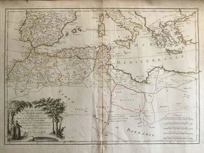
Sold20241837. Map of Barbary Coast. Northwest Africa. Morocco, Algeria, Libya and Tunisia. By A. PerrotTitle: 1837. Map of Barbary Coast. Northwest Africa. Morocco, Algeria, Libya and Tunisia. By A. Perrot Date/Period: 1837 Materials: Hand-colored steel engraving Size: 7 x 10 3/4” This is a map oSee Sold Price
Jun 13Swann Auction Galleries(AFRICA.) Gerard Mercator; and Jodocus Hondius. Two double-page engraved regional maps of the$600
Jun 13Swann Auction Galleries(WORLD and CONTINENTS.) Gerard Mercator; and Jodocus Hondius. Fine set of 5 double-page engraved$11,000
220 Lots AwayJasper52MAGHREB. North Africa Morocco Algeria & Tunisia. JOHNSTON 1913 old antique map$20(1 bid)
2024Jasper52Carte de la Barbarie… l'empire de Maroc… North Africa Morocco. LAPIE 1829 mapSee Sold Price
287 Lots AwayJasper52NORTHERN AFRICA. Morocco Tunisia Algeria. Caravan routes. RAPKIN/TALLIS 1851 map$45
216 Lots AwayJasper52NORTHERN AFRICA. Morocco Tunisia Algeria. Caravan routes.TALLIS/RAPKIN 1851 map$45
250 Lots AwayJasper52Northwest Africa. Morocco Sahara Rio do Oro Ain Sefra Gardaia. STANFORD 1904 map$75
2024Jasper52Northwest Africa. Morocco Sahara Rio do Oro Ain Sefra Gardaia. STANFORD 1904 mapSee Sold Price
6 days LeftLyon & TurnbullAL-JAZULI, 'DALA’IL AL-KHAYRAT WA SHAWRIQ AL-ANWAR', TWO COLOURED DIAGRAMS OF THE TOMB OF THE£420
Jun 23Schilb Antiquarian Rare Books1818 FAMOUS Journal of James Riley Shipwreck Brig Commerce Arabs Morocco Africa$22(3 bids)
257 Lots AwayJasper52NORTH AFRICA. Barbary. Morocco Tunisia Libya Egypt. 'Barbarie'. MALLET 1683 map$20
Jun 13Swann Auction Galleries(AMERICAN SOUTHEAST.) Gerard Mercator; and Jodocus Hondius. Virginiae Item et Floridae Americae$1,300
Jun 13Swann Auction Galleries(TITLE PAGES.) Group of 10 seventeenth-and-eighteenth-century engraved allegorical atlas title$600
2024Jasper52Algeria Morocco & Tunis. North Africa. Tunisia. Maghreb. BARTHOLOMEW 1898 mapSee Sold Price
193 Lots AwayJasper52NORTH AFRICA.Afrika;Atlaslander Morocco Algeria Marokko Algerien 1958 old map$15
264 Lots AwayJasper52NORTH & COLONIAL WEST AFRICA. Nigeria marked as "Royal Niger Company" 1898 map$30


![EUROPAE. [Ortelius, Ca. 1584-1612.] Map.: [Ortelius, Abraham] EUROPAE. [C. 1584-1612.] Engraved map by Ortelius based on Jenkinson’s Russia map and Gastaldi’s maps of Africa and Asia, Gerard Mercator’s 1564 map of Britain, a map of Scan](https://p1.liveauctioneers.com/179/82189/42599765_1_x.jpg?height=310&quality=70&version=1447864785)
![Hondius Map of Morocco: HONDIUS, Jodocus (1563-1612) / MERCATOR, Gerard (1512-1594). [Morocco] Fessae et Marocchi Regna. Engraving with original hand color. Amsterdam, c. 1606 or later. 17 3/4" x 21" sheet. Comparable: Old W](https://p1.liveauctioneers.com/1968/169571/85465312_1_x.jpg?height=310&quality=70&version=1590242353)