Sold2023Bartholomew's "Half-Inch to Mile" Map of England & Wales. Dorset Sheet 34Publication Date: c1920 Title: Bartholomew's "Half-Inch to Mile" Map of England & Wales. Dorset Sheet 34 Cartographer: BARTHOLOMEW, JOHN Publisher: THE EDINBURGH GEOGRAPHICAL INSTITUTE, JOHN BARTHOLOMSee Sold Price
Sold2022Jasper Johns (B. 1930). 'Number Five'.Etching on paper, pencil signed lower right, image 9.25 x 6.75 inches, sheet 13 x 9.75 inches. With SB watermark, the sheet folded in half. Framed, 17 x 21 inches.See Sold Price
Sold2024Russell & Allen (Pub) 1812 Map. England & WalesFolio Copper Engraved Map Published 1812 by Russell and Allen, Manchester for "A New And Commercial System Of Geography" Paper Size: 15.5 x 9 inch (39 x 23cm) Some toning presentSee Sold Price
Sold2021Lochhead (Pub) 1811 Rare Map. England and WalesCopper Engraved Map Published 1811 by William Lochhead, Berwick for "Modern Geography: And a Compendious General Gazetteer" Rare. Folds as issued. Paper Size: 10.5 x 9.5 inch (27 x 24cm) Very minor toSee Sold Price
Sold2022HOMANN, JOHANN BAPTIST. Nova Anglia Septentrionali Americae.HOMANN, JOHANN BAPTIST. Nova Anglia Septentrionali Americae. Double-page engraved map of New England. 20¾x24¼ inches sheet size, wide margins; original hand-color; minor toning but overall aSee Sold Price
Sold2020MORDEN, ROBERT. A New Map of New England and New York.MORDEN, ROBERT. A New Map of New England and New York. Small-scale engraved map of New England on a folio leaf of English text. 8x6½ inches sheet size; preceding text leaf tipped to verso. - LondSee Sold Price
Sold2023Set of 12 Minton England Cobalt Gold Soup BowlsSet of 12 Minton England Cobalt and Gold Soup Bowls. Originally sold at Birks. Pattern number H3998 7. Measuring 9 inches diameter.See Sold Price
Sold2022RUSCELLI, GIROLAMO Tierra Nueva. [Venice: circa 1574]. Copper engraved map. Second state withRUSCELLI, GIROLAMO Tierra Nueva. [Venice: circa 1574]. Copper engraved map. Second state with Italian text on verso. Neat lines 7 x 9.6 inches (18 x 24.4 cm); sheet 9 x 12 1/4 inches (23 x 32 cm). TriSee Sold Price
Sold2019Framed Map of Yorkshire, EnglandEast Riding Division, home of Thomas Tenney before migrating to New England. Map makers: Christopher Saxton, Surveyor and Cartographer; William Kip, Engraver and Printer. [Map: 7 x 9 inches; Frame: 14See Sold Price
Sold2024Antique Map of the World Cummings and HilliardCummings and Hilliard, The World, copper engraved hand colored map, sheet size 9.25 x 17.5 inches, framed 17 x 25.5 inches, from the 4th edition of School Atlas to Cummings' Ancient and Modern GeograpSee Sold Price
Sold2016World Map in Hemispheres 19th CMap: Mapemonde. (World map in hemispheres) Maker: Unknown Origin: French, 19th Century Medium: Original lithograph with hand coloring. Sheet Size: 6 1/4 x 9 inches No Reserve: This lot starts at $1 anSee Sold Price
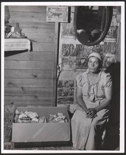
Sold2023JOHN VACHON, “Saginaw County Michigan, Mexican woman living in the sugar beet area.JOHN VACHON, “Saginaw County Michigan, Mexican woman living in the sugar beet area. Silver print, 9 ½ x 7 ½ inch image on a 10 x 8 sheet. Negative number in pencil on verso. “See Sold Price
Sold2021Group of 8 Japanese Woodblock Prints with PoemLot 32 Group of 8 Japanese Woodblock Prints with Poem lot of 8 scenic Japanese recut woodblock prints sheet (largest): 9 3/4 x 13 5/8 inches Provenance: from a private New England collectionSee Sold Price
Sold2018Antique 19th Century Map of Europe9.5x12 inches; McNally's system of geography, map number 21; drawn by J. Wells, N.Y.See Sold Price
Sold2017Arrowsmith: Map of Europe, 1806Map: Europe. Publication Date: 1806 Authors: Aaron Arrowsmith Publisher: Aaron Arrowsmith Size: 7.5 H x 9.3 W Inches From Arrowsmiths 4 Sheet Map of Europe Please note that this lot has a confidentialSee Sold Price
Sold2022Hiroshige155. Hiroshige. Ono no Komach. Woodblock print. 14-1/2 x 10 inches; some fraying at margins. Japan: Ibaya Senzaburô , 1850s [75/100]Number 9 from the series "Ogura Imitations of One Hundred Poems." SSee Sold Price
Sold2019Stanford's Library map of London. Kensington ChelseaReserve Reduced! TITLE/CONTENT OF MAP: 'Stanford's Library map of London and its suburbs [Sheets 9, 10, 13 & 14]' DATE PRINTED: 1877 IMAGE SIZE: Approx 65.0 x 82.0cm, 25.5 x 32.25 inches (Large); PleaSee Sold Price
Sold201919C Royal Worcester Lidded Ewer with Bamboo HandleMANUFACTURE: Royal Worcester (ENGLAND) NAME: Lidded Ewer Pitcher Jug with Bamboo Handle MODEL NUMBER: - YEAR: 1896 CONDITION: two minor faint 1" cracks. HEIGHT: 9 inch / 22 cm WIDTH: 6 inch / 15 cm DESee Sold Price
Sold2018After Francisco GoyaThree etchings with aquatint on paper bearing watermark Jose Zuarro Catalunya: Los Disparates Number 9; Plate 15 (Disparate Claro) , and Plate 18 (Funereal Folly) ; Sheet size, 12 x 17 inches. Plate sSee Sold Price
Sold2018Royal Doulton Orange Lady Porcelain Figuralunderside marked Royal Doulton england the orange lady number 12548; also hand marked non 1789, good condition, ht app 9 inchesSee Sold Price
Sold2018Weller: Antique Map of England & Wales NW, 1863TITLE/CONTENT OF MAP: 'England & Wales, North-West sheet' Cumbria Lancashire Welsh coast Isle of Man. DATE PRINTED: 1863 IMAGE SIZE: Approx 45.5 x 32.5cm, 17.75 x 12.75 inches (Large) TYPE: Antique maSee Sold Price
Sold20237 issues The Manipulator Art and Fashion Magazine 1987Moser, Wilhelm and David Colby (editors), The Manipulator, 7 issues, numbers 9-12 and 14-16, published 1987-1989, large format 27.5 x 19.5 inches, loose sheets as issued, illustrated throughout in colSee Sold Price
Sold2017ANDY WARHOL - Lithograph - Paper BFK. Signed and numberANDY WARHOL.Lithograph paper BFK Rives.Signed in plate and numbered in pencil. - 1995.Issued: 25 unique copies.Measures sheet: 30 cm x 42 cm.Inch 11.81 x 16.53.Measures motif: 24 cm x 24 cm.Inch 9.44See Sold Price
Sold2017The Island of Ceylon Map, 1860The Island of Ceylon. Blackie & Son, Weller, EDW. 1860. No.XLVI. Half sheet map. Shows some topography. Large scale rarely seen in an atlas. Folio – 13.30 H x 10.00 W Inches Please note that this loSee Sold Price
2 days LeftJasper52WEST INDIES. West Indies in Dioceses; USA Bishoprics Church of England 1922 map$10
4 days LeftSwann Auction Galleries(BERMUDA.) Christopher Morley. Autograph Manuscript Signed for his "Notes on Bermuda.”$750
Jul 11Potter & Potter AuctionsCODY, William F. “Buffalo Bill” (1846-1917). Buffalo Bill’s...$200
4 days LeftSwann Auction Galleries(CIVIL WAR--PRINTS.) Ethan Blodgett. Map of a Portion of Roanoke Island, Showing the Battlefield of$750
4 days LeftSwann Auction Galleries(AMERICAN REVOLUTION--HISTORY.) William Gordon. The History of the Rise, Progress, and Establishment$1,500
2 days LeftPotter & Potter AuctionsSHAY, Art (American, 1922-2018) Hemingway and Me. 1945. Printed later.$200


![RUSCELLI, GIROLAMO Tierra Nueva. [Venice: circa 1574]. Copper engraved map. Second state with: RUSCELLI, GIROLAMO Tierra Nueva. [Venice: circa 1574]. Copper engraved map. Second state with Italian text on verso. Neat lines 7 x 9.6 inches (18 x 24.4 cm); sheet 9 x 12 1/4 inches (23 x 32 cm). Tri](https://p1.liveauctioneers.com/292/250642/130213711_1_x.jpg?height=310&quality=70&version=1654271664)


![Hiroshige: 155. Hiroshige. Ono no Komach. Woodblock print. 14-1/2 x 10 inches; some fraying at margins. Japan: Ibaya Senzaburô , 1850s [75/100]Number 9 from the series "Ogura Imitations of One Hundred Poems." S](https://p1.liveauctioneers.com/1352/254382/132649397_1_x.jpg?height=310&quality=70&version=1658086673)
![Stanford's Library map of London. Kensington Chelsea: Reserve Reduced! TITLE/CONTENT OF MAP: 'Stanford's Library map of London and its suburbs [Sheets 9, 10, 13 & 14]' DATE PRINTED: 1877 IMAGE SIZE: Approx 65.0 x 82.0cm, 25.5 x 32.25 inches (Large); Plea](https://p1.liveauctioneers.com/5584/137203/69632494_1_x.jpg?height=310&quality=70&version=1551836574)


![[POSTER MAQUETTE]. Downie Bros Big 3 Ring Circus. [Erie Lit... (1 of 1)](https://p1.liveauctioneers.com/928/333118/179828760_1_x.jpg?height=282&quality=70&version=1718379483)
![[POSTER MAQUETTE]. Al G. Barnes Wild Animal Circus / Red Li... (1 of 1)](https://p1.liveauctioneers.com/928/333118/179828757_1_x.jpg?height=282&quality=70&version=1718379483)


