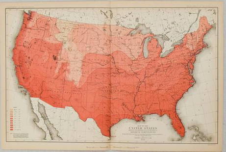
Sold20221879 Powell US Rain Chart Map -- Rain Chart of the United States Showing by Isothermal Lines theTitle: 1879 Powell US Rain Chart Map -- Rain Chart of the United States Showing by Isothermal Lines the Distribution of the Mean Annual Precipitation in Rain and Melted Snow Cartographer: J W Powell /See Sold Price
Sold2022United States rain chart. (1874) by Francis Walker.Title: United States rain chart. (1874) by Francis Walker. Date/Period: 1874 Materials: Color Lithographie printing Size: 17x21" 1874, First Statistical atlas of the US, by Franeis Walker, WashingtonSee Sold Price
Sold20211880 Gannett Climate Map of the US with IsothermalTitle: 1880 Gannett Climate Map of the US with Isothermal Minimum Temperature Lines -- Map of the United states Showing the Distribution of Lines of Minimum Temperature… Cartographer: H Gannett / DeSee Sold Price
Sold2022Temperature chart of the United States. 1874 by FrancisTitle: Temperature chart of the United States. 1874 by Francis Walker. Date/Period: 1874 Materials: Color Lithographie printing Size: 17x21" Showing the distribution by isothermal lines of the mean teSee Sold Price
Sold2016Commercial Map of the US, Principal Lines of RailroadCommercial Map of the United States Showing The Principal Connecting Lines of Railroad David M Warrens 1879, Common School Geography 11.75 x 9.75 inches No Reserve: This lot starts at $1 and has no reSee Sold Price
Sold2017Mitchell: Railroad & Steamboat Map of the US, 1887Map: 1887 Mitchell Railroad and Steamboat Map of the US -- Railroad Map of the United States, Showing the through Lines of Communication from the Atlantic to the Pacific. Together with the Various SteSee Sold Price
Sold2022AJ Nystrom 2-Sided Chalkboard School Map, US & WorldLarge AJ Nystrom Roll Up 2 Sided Chalkboard Classroom Map Chart, US & World. Wonderful chart has maps of the United States and the World outlined in yellow on a black chalkboard backing. From the RoyaSee Sold Price
Sold20221879 Powell Map of US with Railroad Grants -- Map of the United States Exhibiting the Grants ofTitle: 1879 Powell Map of US with Railroad Grants -- Map of the United States Exhibiting the Grants of Lands Made by the General Government to Aid the Construction of Railroads and Wagon Roads. CartogSee Sold Price
Sold20211879 Railroad map of the United States. Cowperthwait.Title: 1879 Railroad map of the United States. Cowperthwait. 8.75 x 10.75 Description: "Unusual and thorough hand-colored map showing the network of rail lines in the eastern half of the United StatesSee Sold Price
Sold2021New Mexico177. New Mexico.Graham, James D. Report...on the Subject of a Boundary Line between the United States and Mexico. 2 folding maps, folding chart. 8vo, removed; remnants of leather on spine, generally sSee Sold Price
Sold20231853 Colton Map of the US Midwest -- Guide through Ohio, Michigan, Indiana, Illinois, Missouri,Title: 1853 Colton Map of the US Midwest -- Guide through Ohio, Michigan, Indiana, Illinois, Missouri, Wisconsin & Iowa. Showing the Township Lines of the United States Surveys … Cartographer: JSee Sold Price
Sold2019U S Coast Survey 1896 Base Map of The United States"Isogonic Chart of the United States for the Epoch January 1900" Large Lithograph Map Published 1896, Washington for "U.S. Coast and Geodetic Survey" Folds as issued. Rare. Paper Size: 30.5 x 23.5 incSee Sold Price
Sold20201884 Mitchell Railroad Map of the United States --Title/Content of Map: 1884 Mitchell Railroad Map of the United States -- Railroad Map of the United States, Showing the through Lines of Communication from the Atlantic to the Pacific. Together with tSee Sold Price
Sold20211887 Mitchell Railroad Map of the United States --Title: 1887 Mitchell Railroad Map of the United States -- Railroad Map of the United States, Showing the through Lines of Communication from the Atlantic to the Pacific. Together with the Various SteaSee Sold Price
Sold2019Railroad Map of the United States Showing the ThroughReserve Reduced! Title: Railroad Map of the United States Showing the Through Lines of Communication from The Atlantic to The Pacific... Publication Date: 1886 Cartographer: BRADLEY, WM. M. Publisher:See Sold Price
Sold2021ca. 1929 RAILROAD UNITED STATES MAP SHOWING NEW YORKVintage Railroad Map, "MAP of THE UNITED STATES SHOWING NEW YORK CENTRAL LINES". Map by Rand McNally and Co. Includes printed information on the reverse. Tiny text along bottom partly reads; "NY 4-29"See Sold Price
Sold20221880 US Census Map of Oats Production -- Map of the United States Showing the Average Yield of OatsTitle: 1880 US Census Map of Oats Production -- Map of the United States Showing the Average Yield of Oats per Acre… Cartographer: US Census Bureau Year / Place: 1880, Boston Map Dimension (in.)See Sold Price
Sold20231880 US Census Map of Barley Production -- Map of the United States Showing the Average Yield ofTitle: 1880 US Census Map of Barley Production -- Map of the United States Showing the Average Yield of Barley per Acre… Cartographer: US Census Bureau Year / Place: 1880, Boston Map Dimension (See Sold Price
Sold20231880 US Census Map of Corn Production per Capita -- Map of the United States Showing theTitle: 1880 US Census Map of Corn Production per Capita -- Map of the United States Showing the Distribution of Production of Indian Corn in Bushels per Capita… Cartographer: US Census Bureau YeSee Sold Price
Sold20231880 US Census Map of Wheat Production per Capita -- Map of the United States Showing theTitle: 1880 US Census Map of Wheat Production per Capita -- Map of the United States Showing the Distribution of Production of Wheat in Bushels per Capita… Cartographer: US Census Bureau Year /See Sold Price
Sold20231880 US Census Map of Oats Production per Capita -- Map of the United States Showing theTitle: 1880 US Census Map of Oats Production per Capita -- Map of the United States Showing the Distribution of Production of Oats in Bushels per Capita… Cartographer: US Census Bureau Year / PlSee Sold Price
Sold20191886 Mitchell/Bradley Railroad and Steamboat Map of theTitle: 1886 Mitchell/Bradley Railroad and Steamboat Map of the US -- Railroad Map of the United States Together with the Various Steamship Lines along the Seaboard Date: 1886, Philadelphia CartographeSee Sold Price
Sold2018Rand McNally: Antique US Population Trend Map, 1892Title/Content of Map: 1892 Rand McNally US Population Trend Map -- Rand McNally & Co.'s Map of the United States Showing the Increase and Decrease of Population 1880 to 1890 Date Printed: 1892, ChicagSee Sold Price
Sold20211898 Rand McNally US Population Density Map -- RandTitle: 1898 Rand McNally US Population Density Map -- Rand McNally & Co.'s Map of the United states Showing in Six Degrees the Density of Population, 1890 Cartographer: Rand McNally Year / Place: 1898See Sold Price
7 days LeftJasper521880 Map of US Wheat Farming -- Map of the United States Showing the Distribution of Production of$45
7 days LeftJasper521880 Map of US Tobacco Production by Type of Tobacco -- Map of the United States Showing the Regions$45
Jun 13Swann Auction Galleries(UNITED STATES -- RAILROADS.) Edward Stanford. Stanford's Map of the United States Showing the$500
Jun 23East Coast Fine Arts LLC1777 US Revolutionary War Map French Brion de la Tour Theatre de Guerre$1,000
3 days LeftSimpson Galleries, LLC.J.H. Young (1792-1870) AN AMERICAN FEDERAL PERIOD MAP, "Mitchell's Travellers Guide Through the$500
3 days LeftSimpson Galleries, LLC.JULIUS BIEN (1826-1909) AN AMERICAN CIVIL WAR RECONNAISSANCE MAP, "Map of Texas and Part of New$100
Jun 13Swann Auction Galleries(DUTCH EAST INDIA COMPANY -- JAVA SEA.) Isaak de Graaf. Manuscript chart of Java, the Java Sea,$80,000
3 days LeftTrillium Antique Prints & Rare BooksKohler & Weigel - Map of Louisiana Territory or Eastern United States (extends from New Mexico to$120(4 bids)
Jun 30Global Auctions CompanyNorio Azuma Japanese Amer 1928-2004 Serigraph Flower Zone Ltd Ed signed$450
Jun 30Global Auctions CompanyOldrich Farsky (Czech American 1860 - 1930) Oil painting Portrait of a Seaman$350


![U.S. Stamp Albums (10) [181754] (1 of 5)](https://p1.liveauctioneers.com/2699/331499/178846709_1_x.jpg?height=282&quality=70&version=1717095214)

