Sold2021Color pictorial bird's-eye airline route maps 1929Heading: (Aviation - pictorial route maps) Author: Title: Western Air Express: Travel by Air, Speed - Comfort - Dependability Place Published: [California?] Publisher:Western Air Express Date PuSee Sold Price
Sold2022Vintage Faller Caravelle SUD-Aviation 1:100 Scale Model KitVintage Faller Caravelle SUD-Aviation 1:100 Scale Model KitSee Sold Price
Sold2022Vintage Faller Caravelle SUD-Aviation 1:100 Scale Model KitVintage Faller Caravelle SUD-Aviation 1:100 Scale Model KitSee Sold Price
Sold20221960 Hawaiian Airlines Pictorial Route Map -- The Hawaiian IslandsTitle: 1960 Hawaiian Airlines Pictorial Route Map -- The Hawaiian Islands Cartographer: Hawaiian Airlines Year / Place: 1960 Map Dimension (in.): 8.9 X 20.2 in This is an attractive pictorial airlineSee Sold Price
Sold2023[AVIATION]. Two pictorial maps. Includes: CHEESEMAN, F.E. A...[AVIATION]. Two pictorial maps. Includes: CHEESEMAN, F.E. Aviation Panorama. 1943. Milwaukee: Albert Richard Company. Colorful pictorial map in “Tribute to the Pioneer Spirit, the Inventive GeniSee Sold Price
20241962 Braniff Airways Pictorial Route Map -- Fly Braniff International AirwaysTitle: 1962 Braniff Airways Pictorial Route Map -- Fly Braniff International Airways Cartographer: Braniff Year / Place: 1962 Map Dimension (in.): 11 x 8 in. A nice route map of now discontinued BraniSee Sold Price
Sold2017PanAm Vintage Pictorial Map of Australia & Oceania 1960Title/Content of Map: 1960 PanAm Pictorial Map of Australia and Oceania -- Australie Oceanie Date Printed: 1960 Cartographer: J Liozu / PanAm Size: 11.8 x 9 in. Very attractive pictorial map of AustraSee Sold Price
Sold2017PanAm: Vintage Pictorial Map of Asia, 1960Map: 1960 PanAm Pictorial Map of Asia -- Asiae Cartographer: J Liozu / PanAm Year / Place: 1960 Map Dimensions: 11.8 x 9 in. Condition: Very Good. Nice, sharp image and colors.Later center-fold. VerySee Sold Price
Sold20201930 Japanese Mainichi Newspaper World Air RouteTitle: 1930 Japanese Mainichi Newspaper World Air Route Pictorial Map -- Conquer Sky Sugoroku [World Air Route Map] Cartographer: Mainichi Newspaper Year / Place: 1930, Osaka Map Dimension (in.): 26.8See Sold Price
Sold2022WWII US Air Force Safety Poster "They Cheer When You Forget Your Maps"WWII Political Propaganda Poster."They Cheer When You Forget Your Maps." WWII Aviation Safety Poster issued by US Air Force. Nice Condition - Just some fold lines. Framed. Measures 24" wide x 19.5" taSee Sold Price
Sold2021Ireland pictorial map showing places of interestIreland pictorial map showing places of interest original poster printed for Irish Tourist Board by Brown & Nolan c. 1960 - 102 x 63 cm and The Book of Kells original poster printed by Hely Thom 1964See Sold Price
Sold2024McCARTY, Lea (1905 – 1960). Sonoma County / Its Highlights ...McCARTY, Lea (1905 – 1960). Sonoma County / Its Highlights Fill this Cartograph / Its Yardsticks Appear Below. 1951. An expansive pictorial map showing the county’s history and present daySee Sold Price
Sold2016Anon Ireland Pictorial Map showing some of the placesAnon Ireland Pictorial Map showing some of the places of scenic and historic interest, original poster printed for the Irish Tourist Board by Browne & Nolan c.1960 - 102 x 63 cm; and Ireland AasleaghSee Sold Price
Sold20201956 Pan Am World and Germany Route Map -- WillkommenTitle: 1956 Pan Am World and Germany Route Map -- Willkommen an Bord! Pan Am Cartographer: Pan American Airways Year / Place: 1956 Map Dimension (in.): 15.3 X 8.3 in. A very nice pictorial map of theSee Sold Price
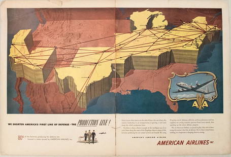
Sold20231950s American Airlines Route Map -- American Airlines Route MapTitle: 1950s American Airlines Route Map -- American Airlines Route Map Cartographer: American Airlines Year / Place: 1950s Map Dimension (in.): 12.5 X 19.2 in. joined This nice, large pictorial routeSee Sold Price
Sold20181961 Panagra / PanAm Pictorial Map of South AmericanTitle/Content of Map: 1961 Panagra / PanAm Pictorial Map of South American Air Routes -- The Only Jet Service 'Round South America Date: 1961 Cartographer: PanAm Size: 10.5 x 8 in. A nice air Route MaSee Sold Price
Sold2016C Dohet (Claude dates unknown) Sabena Pictorial MapC Dohet (Claude dates unknown) Sabena Pictorial Map centring on Africa, original small poster printed by Linsmo c. 1960 - 34.5 x 22 cmSee Sold Price
Sold2023Safari Today by Robert M. Lee SIGNEDSafari Today by Robert M. Lee. Inscribed to 'Jack' and author signed. Stackpole Co. 1960 with unclipped dust jacket. 227 pp. Illustrated. Pictorial map endsheets. Brown covers with red lettering. MeasSee Sold Price
Sold2023Vivai del Sud (attr.), Due poltrone da giardinoDue poltrone da giardino Canna d'India, midollino. Prod. Vivai del Sud, 1960 ca. cm 92x56x54See Sold Price
Sold2022(PICTORIAL MAPS.) D.E. Bates. Cunard R.M.S. Caronia / Great African Cruise 1950.(PICTORIAL MAPS.) D.E. Bates. Cunard R.M.S. Caronia / Great African Cruise 1950. Color offset-printed pictorial map advertising the Caronia's route on a two-and-a-half-month's-long affair: departing NSee Sold Price
Sold202332 Troy Ozs. Of Gold Filled Aviation Lapel Pins1960's Federal Aviation Agency United States Of America, (faa), Tie Tac Pin, Gold Filled Service Award Pin. All Pins Are Marked H. L. P. 1/10 Of 10k Pins. 2.19 Pounds Or 31.98 Ozt, Or 995 Grams.See Sold Price
Sold2018MAURIZIO CATTELAN1960 A.C. Forniture Sud, 1991 Plexiglass, cartoncino serigrafato e fustellato e fischietto, cm 18 x 23 x 17,5 Firmato, datato e numerato sotto la base Esemplare XI/XVSee Sold Price
Sold202384 Troy Ozs Sterling Silver Aviation Lapel Pins1960's Faa, Federal Aviation Agency United States Of America, (faa), Tie Tac Pin, Sterling Silver Service Award Pin. All Pins Are Marked H. L. P. Ster. Weight: 5.79 Pounds Or 84.55 Ozt, Or 2630 Grams.See Sold Price
Sold2024(PICTORIAL MAPS.) John Held, Jr. Motor Routes to "Real New England Inns".(PICTORIAL MAPS.) John Held, Jr. Motor Routes to "Real New England Inns". Offset color-printed map of New England comically illustrated by Held's characteristic figures. 20½x24¾ inches sheetSee Sold Price
Jun 27Rail & Road AuctionsTen Gulf, Mobile & Ohio Railroad Playing Card Decks - Alton Route Map and Logo$70
10 hrs LeftThe Ross Art GroupOriginal Vintage Air France World Route Map Vickers Viscount Poster 1956 Constellation$600
8 hrs LeftARTMAXIMUM[Soviet. Air Fleet Day of the USSR. The first aviation parade. Klutsis G., photomontage]. [The€120
Jun 29JM Hobby Supply and Railroad Artifact AuctionsFlorence & Cripple Creek RR Public Timetable-September 1894$400
2 days LeftActivity AuctionsEXTREMELY RARE! Winter 1948-49 KLM AIRLINES World Route Wall Map, Vintage Travel$1,500
10 hrs LeftSwann Auction GalleriesRICHARD ERDOES (1912-2008) The Last Days of the Late Great State of California.$600
Jun 27Rail & Road Auctions45 Peices of Western Railroad Paper Ephemera - Southern Pacific, Northern Pacific, Union Pacific,$30(1 bid)
Jul 06Rafael Osona AuctionsVintage Tilghman Packing Co. "Historical Map of the Maryland Eastern Shore", circa 1957$100


![Color pictorial bird's-eye airline route maps 1929: Heading: (Aviation - pictorial route maps) Author: Title: Western Air Express: Travel by Air, Speed - Comfort - Dependability Place Published: [California?] Publisher:Western Air Express Date Pu](https://p1.liveauctioneers.com/642/204898/103985846_1_x.jpg?height=310&quality=70&version=1621652446)


![[AVIATION]. Two pictorial maps. Includes: CHEESEMAN, F.E. A...: [AVIATION]. Two pictorial maps. Includes: CHEESEMAN, F.E. Aviation Panorama. 1943. Milwaukee: Albert Richard Company. Colorful pictorial map in “Tribute to the Pioneer Spirit, the Inventive Geni](https://p1.liveauctioneers.com/928/305275/163151863_1_x.jpg?height=310&quality=70&version=1697054833)


![1930 Japanese Mainichi Newspaper World Air Route: Title: 1930 Japanese Mainichi Newspaper World Air Route Pictorial Map -- Conquer Sky Sugoroku [World Air Route Map] Cartographer: Mainichi Newspaper Year / Place: 1930, Osaka Map Dimension (in.): 26.8](https://p1.liveauctioneers.com/5584/187575/94368587_1_x.jpg?height=310&quality=70&version=1607465981)


![[Soviet. Air Fleet Day of the USSR. The first aviation parade. Klutsis G., photomontage]. [The (1 of 2)](https://p1.liveauctioneers.com/6171/331358/178722692_1_x.jpg?height=282&quality=70&version=1716885834)


