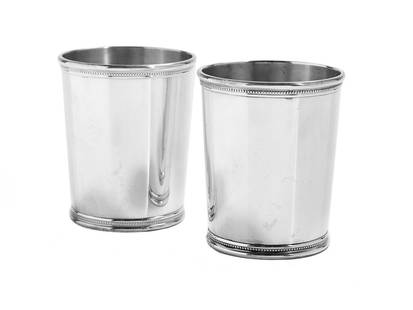
Sold2020Two Kentucky Sterling Silver Mint Julep CupsTwo Kentucky Sterling Silver Mint Julep Cups 1963-1968, by Mark J. Scearce, Shelbyville, Kentucky, of traditional slightly tapering cylindrical form with beaded and molded rims, each with the originalSee Sold Price
Sold2019Two Maps by the Hydrographic Office U. S. Navy,Two Maps by the Hydrographic Office U. S. Navy, consisting of "China- East Coast- Hwangpoo River, Kaokiao Creek to Yangtzepoo Creek," 1931, H. - 42 in., W. - 30 in.; together with "China- East Coast-See Sold Price
Sold2024Two Maps of the United States by William Faden (London, 1785 and 1796)Two Maps of the United States by William Faden (London, 1785 and 1796) Two hand-colored maps engraved by William Faden (British, 1749-1836), London, 1785 and 1796. Titled "The United States of North ASee Sold Price
Sold2019Two Maps by Matthaus Seutter (1678-1757), "AccurataTwo Maps by Matthaus Seutter (1678-1757), "Accurata Delineatio Celeberrimae Regionis Ludocianae vel Gallice Louisiane al Canadae et Floridae adpellatione in Septemtrionali America, Mississippi, St. LoSee Sold Price
Sold2019Two Maps by Willem Janszoon Blaeu (1571-1638),Two Maps by Willem Janszoon Blaeu (1571-1638), "Virginiae partis australis et Florida partis orientalis," 1640, hand colored, H. - 15 in., W. - 20 in.; together with India Quae Orientalis Diktur et InSee Sold Price
Sold2022Ortelius and Hondius - Two Maps, Florida and Caribbeanincluding: Abraham Ortelius (1527-1598), La Florida/Guastecan/Peruviae Auriferae Regionis Typus, Amsterdam, circa 1584-1609, text verso, in two sheets, engraving on laid paper with hand colored highliSee Sold Price
Sold2021Two Maps of Southwestern American InterestTwo Maps of Southwestern American Interest comprising the Map Of The Route Pursued In 1849 By The U.S. Troops, Under the Command of Bvt. Lieut. Col. Jno. M. Washington, Governor [of] New Mexico, in anSee Sold Price
Sold2015Two maps of the Sandwich Islandsincluding Charte von den Sandwich Inseln by James Cook (1728- 1779), published in Des Capitan Jacob Cook's dritte Entdeckungsreise, 1788, depicting Cook's route through the Sandwich Islands/Hawaii, wiSee Sold Price
Sold20222 Southern Maps: Kentucky, 1800 and Southern U.S. 17971st item: THE STATE OF KENTUCKY WITH THE ADJOINING TERRITORIES FROM THE BEST AUTHORITIES 1800, engraved by John Scoles for "New Encyclopaedia" by John Payne, published by John Low, New York, 1800. CopSee Sold Price
Sold2019Two Maps by Abraham Ortelius (1527-1598), "PeruviaeTwo Maps by Abraham Ortelius (1527-1598), "Peruviae Auriferae Regionis Typus, La Florida Aue Torre Hieron Chiaues, Guastecan Reg," each containing three hand colored maps on two sheets, 1595, hand colSee Sold Price
Sold2023Giambattista Albrizzi. Two Maps of North America(Italian, 1698-1777). Map of North America and map of Canada and the Great Lakes, 1740, engravings, sight size of each: 13 1/2 x 17 in., both framed.See Sold Price
Sold2019Two Maps by Jean Baptiste D'Anville (1699-1782), "Two Maps by Jean Baptiste D'Anville (1699-1782), " America Septentrionales, Coloniis lnteriorem Virginiam deductis, Ohio," 1756 and 1777, H. - 20 in., W. - 23 5/8 in. (2 Pcs.)See Sold Price
Sold2019Two Maps by Olfert Dapper (1636-1689), "Nova VirginiaTwo Maps by Olfert Dapper (1636-1689), "Nova Virginia Tabula, " 1650, H. - 12 1/4 in., W. - 15 in.See Sold Price
Sold2024Two Maps of Switzerland Including MollProperty from the Estate of a Swiss UBS Executive, Zurich and Hilton Head Island, SC Description: Two Maps of Switzerland Including Moll, including H. Moll, from Atlas Minor, Published London, 172See Sold Price
Sold2023With duo-tone lithograph plates and two mapsHeading: Author: Smith, Murray D. Title: Arctic Expeditions, British and Foreign. From the Earliest Period to the Present Time. Place Published: Glasgow Publisher:Thomas Liddell Date Published:See Sold Price
Sold2019Two Maps by Jacques Nicolas Bellin (1703-1772), "PartieTwo Maps by Jacques Nicolas Bellin (1703-1772), "Partie Occidental de la Nouvelle France du Canada (Great Lakes)," 1755; together with "Carte de la Louisiana et Pays Voisins," 1757, both hand colored,See Sold Price
Sold2022Two Kentucky Stoneware Whiskey JugsTwo Kentucky Brown and White Stoneware Two Gallon Whiskey Jugs. (1) "Applegate & Son's Distillers, Louisville, Ky" two gallon whiskey jug. (1) "Jos. Leopold & Bro., Belleville, Ill. Fine KY. Whiskies"See Sold Price
Sold2018Two Maps of Connecticut TownsTown of Goshen 32" x 41" dated 1853 Town of Sharon 36" x 43"See Sold Price
Sold2023[PICTORIAL MAPS]. Two maps. Includes: JANNOT, J.B. (“Jan Lo...[PICTORIAL MAPS]. Two maps. Includes: JANNOT, J.B. (“Jan Loup”). Grand Circuit Des Capitales. France: Agence Francaise de Propagande. Promotional map of Europe and Asia for Menier chocolatSee Sold Price
Sold2024Two Maps of The Golden Islands and Ismuth of Darien by John Senex (London, 1721)Two Maps of The Golden Islands and Ismuth of Darien by John Senex (London, 1721) Two engraved maps by John Senex (British, 1678-1740 ), published in A New General Atlas, London, 1721. Including "A DraSee Sold Price
Sold2019With two maps featuring California as an island, 1752Heading: (California as an Island) Author: de Chevigni; de Limiers; Massuet, Pierre Title: La Science Des Personnes De Cour, D'Epe?e Et De Robe. Place Published: Amsterdam Publisher:Z. Chatelain & FilSee Sold Price
Sold2019Group of Two MapsAn Accurate Map Of Turky (sic) in Europe Drawn from the best Authorities 8 1/4" x 11 3/4" (sight) hand colored together with Tabula Freti Siculi Charibdis et ScyllaeSee Sold Price
Sold2023Two Maps of the AmericasTwo maps, one of the United States dated 1876 by Samuel Augustus Mitchell, the other of "Guiana siue Amazum Regio", 17th century. Dimensions: the map of the Amazon sight is 17 3/4See Sold Price
Nov 12J. Greenstein & Co., Inc.TWO MAPS OF THE HOLY LAND. Exceptionally large. Probably used for classroom instruction.$50
Oct 18Rail & Road Auctions1878 Maps of the New and Popular St. Louis and Texas Short Line Railroad Color Lithograph$40
20 hrs LeftArader GalleriesDavid Ramsay First Edition of The History of the Revolution of South-Carolina$8,000
2 days LeftNY Elizabeth 1741 AN ANCIENT HISTORY OF THE CONQUEST OF MEXICO SPANISH ILLUSTRATED FOLIO$150(2 bids)
5 days LeftJasper52LONDON UNDERGROUND tube map plan diagram. Northern Heights SCHLEGER/ZERO #3 1939$260
5 days LeftJasper52LONDON UNDERGROUND tube map diagram plan. Northern Heights SCHLEGER/ZERO #2 1939$260
Oct 12JM Hobby Supply and Railroad Artifact AuctionsHammonds Map of Kentucky and Tennessee Railroads-1910$30
2 days LeftNY Elizabeth THE 1853 EXPLORATION OF LOUISIANA'S RED RIVER IN 1852, AS SEEN IN AN ANCIENT ILLUSTRATION$50
2 days LeftNY Elizabeth FIRST US EDITION OF 1869 MALAY ARCHIPELAGO BY A.WALLACE, ANTIQUE ILLUSTRATED WITH MAPS$50
5 days LeftJasper52General Map of the West Indies'. West sheet only. Bryan EDWARDS. Caribbean 1794$700
5 days LeftJasper52The United Parishes of St. Giles in the Fields & St. George, Bloomsbury 1828 map$550


![Two Maps of Southwestern American Interest: Two Maps of Southwestern American Interest comprising the Map Of The Route Pursued In 1849 By The U.S. Troops, Under the Command of Bvt. Lieut. Col. Jno. M. Washington, Governor [of] New Mexico, in an](https://p1.liveauctioneers.com/197/208667/106254762_1_x.jpg?height=310&quality=70&version=1624480701)


![[PICTORIAL MAPS]. Two maps. Includes: JANNOT, J.B. (“Jan Lo...: [PICTORIAL MAPS]. Two maps. Includes: JANNOT, J.B. (“Jan Loup”). Grand Circuit Des Capitales. France: Agence Francaise de Propagande. Promotional map of Europe and Asia for Menier chocolat](https://p1.liveauctioneers.com/928/305275/163151899_1_x.jpg?height=310&quality=70&version=1697054833)


