Sold2022Rare Walling's RR map of Upper Mississippi, 1868This rare map of the mid-continent is most noteworthy for its unusual configuration of Dakota Territory, pre-dating the formation of Wyoming. The map includes early appearances of Colorado Territory aSee Sold Price
Sold2022Pre-statehood map of District of Maine, 1814An important, original early map of Maine six years before achieving statehood, and several years before the northern and upper northeastern boundaries are finally settled. Engraved by John G. WarnickSee Sold Price
Sold2022Scarce map of NW territories, Hardesty 1875Scarce regional map of the Wyoming Territory, Montana Territory, Dakota Territory and Nebraska, colored by counties and showing towns, mountains, rivers, railroads, etc. One of the few maps to show WySee Sold Price
Sold20201888 Map of WyomingAuthor: Cram Title: 1888 Map of Wyoming Medium: Ink on Paper Dimensions: 13.5"X11.5" Map of Wyoming dated 1888. Engraved and published by Georger Cram in Chicago. Key upper right. Border. Engraved jusSee Sold Price
Sold20211888 Map of WyomingAuthor: Watson Title: 1888 Map of Wyoming Medium: Ink on Paper Dimensions: 14"X10.5" Map of Wyoming dated 1888. Engraved and published by Watson in Chicago. Key upper right. Color coded for territoriaSee Sold Price
Sold20201888 US & Territories mapAlso includes part of the west India islands. Scale of statue miles 40-1in. Dated Dec 31 1888 by the General land office. Overall size 82" wide X 64" high. Some losses. Brittle.See Sold Price
Sold2023F. Gray's Idaho, Montana and Wyoming Map 1870Featured in this lot is an excellent, hand-colored early map of Idaho Territory, Wyoming Territory and Montana Territory, published by O.W. Gray and drawn by Frank A. Gray. Wyoming is shown with onlySee Sold Price
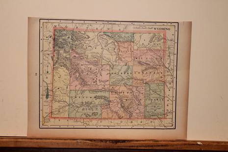
Sold2021Map of Territory of WyomingMap of Territory of Wyoming Color Map Dated: 19th century Dimensions: 10 x 6 1/2" Condition Report Good. Text on verso. Subject ReferenSee Sold Price
Sold2015Map of Territory of Wyoming Co., Plate No. 86Map of Territory of Wyoming Co., Plate No. 86Fifty mile scaleDimensions: 11 1/4" X 14"Inv.54See Sold Price
Sold20221oz Gold Clad Pre War German Territorial Bullion BarPre-War Territory Boundary Map – Encapsulated – This is a Novelty Gold Plated Bar containing No Precious Metals – This should not be purchased as an investment – It is simpSee Sold Price
Sold20201888 Map of Oklahoma/Indian TerritoryTitle: 1888 Map of Oklahoma/Indian Territory Author: Cram Medium: Ink on Paper Dimensions: 14.5"X11.5" Map of Oklahoma and the Indian territory dated 1888. Engraved and published by George Cram in ChiSee Sold Price
Sold2017Johnson: Antique Map Nebraska Dakota Idaho MontanaJohnson’s Nebraska, Dakota, Idaho and Montana, c1865. One of the earliest appearances of Wyoming on a map -- so early, it has not been added to the map title. Pre-dates Yellowstone. Wyoming is in aSee Sold Price
Sold20201888 Map of Oklahoma and the Indian territoryAuthor: Cram Title: 1888 Map of Oklahoma and the Indian territory Medium: Ink on Paper Dimensions: 14.5"X11" Map of Oklahoma and the Indian territory dated 1888. Engraved and published by George CramSee Sold Price
Sold2015Map of Yellowtone Lake 1871Heading: Author: U.S. Geological Survey Title: Yellowstone Lake Wyoming Territory Place Published: Washington Publisher: Date Published: 1871 Description: Lithographed map.See Sold Price
Sold20221871 Hayden Map of Yellowstone LakeYellowstone Lake Wyoming Territory / Surveyed by the Party in charge of F.V. Hayden U.S. Geologist 1871. Good condition; small tear right side (cellophane tape to the reverse), normal age toning, smalSee Sold Price
Sold2024Military Wagon-Road In Wyoming And Montana Territories With Map Of Military Reconnaissance 1873-4Military Wagon-Road Un Wyoming And Montana Territories With Map Of Military Reconnaissance 1873-4Pamphlet: Letter From The Secretary Of War, WM. W. Belknap with report of the Captain of Engineers, W.See Sold Price
Sold2024Civil War era map of N. America with unsettled state bordersOne of the key maps in the 1860s Johnson series of North America. In this map Idaho Territory encompasses what would eventually become Idaho, Montana and Wyoming. Dakota Territory has yet to split intSee Sold Price
Sold2022Vintage map of North America, Johnson/Ward, 1865Dynamic map of the North American continent with Dakota still a complete territory (Wyoming still part of Dakota). Nevada, Utah, Arizona still with unsettled borders and Oklahoma remains Indian TerritSee Sold Price
Sold2022Civil War era map of N. America with unsettled state bordersOne of the key maps in the 1860s Johnson series of North America. In this map Idaho Territory encompasses what would eventually become Idaho, Montana and Wyoming. Dakota Territory has yet to split intSee Sold Price
Sold2023Colorado Territory MapColorado Territory Map Published by O.W Gray a year before Colorado became a statehood. Hand colored lithograph ca. 1875 Sight: 12" x 14 3/4Frame: 12 1/2" x 17 1/2"See Sold Price
Sold2022Scarce map showing short-lived Idaho border, JohnsonMost striking feature of this map is the massive Idaho Territory, which includes all of what would become Wyoming and Montana Territories. Formed in March 1863, Idaho Territory remained in the configuSee Sold Price
Sold20231872 MAPS Geological Survey USA Territories Montana Idaho Wyoming Utah GEOLOGY1872 MAPS Geological Survey USA Territories Montana Idaho Wyoming Utah GEOLOGY Commissioned by the United States government, Ferdinand Vandeveer Hayden and a select crew were sent to further explore tSee Sold Price
Sold2018Scarce 1848 map of Wisconsin by S. Augustus MitchellReserve Reduced! From the increasingly scarce 1848 New Universal Atlas by S. Augustus Mitchell. Pre-1850 Mitchell maps are becoming quite scarce. Image of Wisconsin Territory the year it became a statSee Sold Price
Sold2022Uncommon map of Oklahoma & Indian Terr., 1897Unusual wax engraved map of Oklahoma Territory/Indian Territory ten years before the region achieved statehood. Numerous Indian nations located throughout. Shows railroads with routes named, towns, riSee Sold Price
6 days LeftSchilb Antiquarian Rare Books1877 Geology Geography Surveys 1ed Nevada Wyoming Utah George Wheeler US West 2v$1(1 bid)
Featured2 days LeftJasper52Hawaii & American Samoa. Pictorial state map by Ruth Taylor White 1935 old$140
Featured2 days LeftJasper52Large BASIKASINGO Ancestor Figure Congo Sikasingo Kasingo Statue Pre Bembe 1300$700
Jul 06Case Antiques, Inc. Auctions & AppraisalsColton's Atlas of the World, 1856, in Two Volumes; plus Africa / Mahdist War Map$500
1 day LeftJasper521888 (Updated in 1939) British Admiralty Nautical Chart of Cherbourg Area on France's North Coast$60
BonhamsART â013 ARTHUR HUGHES & THE PRE-RAPHAELITES Archive relating to the Pre-Raphaelite artist,...£800(1 bid)
BonhamsWAUGH (EVELYN) Brideshead Revisited. The Sacred and Profane Memories of Captain Charles Ryder, O...£7,000
3 days LeftCambi Casa D'AsteJaeger-LeCoultre Reverso Grand Taille “Greater China?? edition with enamel on the back, limited€6,000
BonhamsBASKERVILLE PRESS ADDISON (JOSEPH) The Works, 4 vol., Birmingham, Printed by John Baskerville, f...£500
Jul 12One of a Kind Coins1 of 1: $10 GEM BU Morgan Silver Dollar Bank Roll O/CC & 1888 SCAR FACE Ends$5,250(8 bids)
Jul 12One of a Kind Coins1 of 1: $10 GEM BU Morgan Silver Dollar Bank Roll 1888 Hot Lips and O/S Ends$3,250(8 bids)
6 days LeftCurated Gallery AuctionsOliver Rhys (fl.1876-1895) Antique English Pre Raphaelite Elegant Woman Portrait Oil Painting$120(3 bids)