Sold20221782 Cary Map of St. Kitts and Nevis -- An Accurate MapTitle: 1782 Cary Map of St. Kitts and Nevis -- An Accurate Map of the Islands of St. Christophers and Nevis in the West Indies Cartographer: J Cary Year / Place: 1782, London Map Dimension (in.): 12.1See Sold Price
Sold2023The Island Sainte Croix, 1831 British Admiralty Nautical ChartScarce Original 1831 British Admiralty Nautical Chart: The Island Sainte Croix, of From the 1799 Danish Survey of General Oxholm. An Extraordinary 18th-Century Map of the Danish Sugar-Plantation IslanSee Sold Price
Sold2017Moll: The Island of St Christophers, 1729Map: The main island of St Kitts and Nevis in the Leeward "Islands of the Lesser Antilles Publisher: Herman Moll, London Publishing Date: 1730 Size: 8 x 10.75 inches Large compass rose. Original outliSee Sold Price
Sold2021An Accurate Map of the Islands of St. Christopher andAn Accurate Map of the Islands of St. Christopher and Nevis in the West Indies, 1782A map of the islands Nevis and St. Kitts with topographical information for both. A depiction of both the French fleSee Sold Price
Sold2023Antique French Map Isle de Saint ChristopheAntique MDCCLVIII French Language Hand Colored Map of Isle de Saint Christophe (St. Kitts), Framed. 31 inches x 42 inchesSee Sold Price
Sold2024Hernán Cortés Sugar Plantation's Parish Record, Listing Numerous SlavesHernan CortesSan Antonio Atlacomulco, ca. 1768Hernán Cortés Sugar Plantation's Parish Record, Listing Numerous SlavesBooksA fascinating manuscript record for the church of Santa Madre in SanSee Sold Price
Sold2017Homann: British West Indies/Atlantic Islands Map, 1740Map: Dominia Anglorum. British West Indies/Atlantic islands of St Christopher (St Kitts), Antigua, Bermuda, Jamaica & Barbados Date Printed: c1740 Image Size: Approx 52.5 x 59.5cm, 20.5 x 23.25 inchesSee Sold Price
Sold2023St Kitts Nevis St Eustatius Saba Leeward Islands ADMIRALTY chart 1864 (1961) mapTITLE/CONTENT OF MAP: 'West Indies - Leeward Islands - St. Eustatius, St. Christopher & Nevis // Basseterre Bay // Saba // St. Eustatius - Orange Baai' DATE PRINTED: Surveyed 1848-1959. Published 1864See Sold Price
Sold2023St Kitts Nevis Montserrat Saba Eustatius Caribbean US Navy chart 1887 (1917) mapTITLE/CONTENT OF MAP: 'West Indies - St. Eustatius, St. Christopher, Nevis and Montserrat // Aves Island (Venezuela) // St. Eustatius (Statia) // St. Christopher // Montserrat I. // Saba Island (DutchSee Sold Price
Sold20181984 Government Map of Nevis -- Nevis with Parts ofTitle/Content of Map: 1984 Government Map of Nevis -- Nevis with Parts of Saint Christopher (Saint Kitts) Date: 1984 Cartographer: Government of Saint Christopher (St. Kitts) and Nevis Size: 34 x 26.2See Sold Price
Sold2022Antique Framed Engraved Map of Brazil"Office of Pernambuco Northern Region" (caption translation). This engraving of a map of Brazil includes an inset image showing a sugar plantation and enslaved people engaged in various tasks. In theSee Sold Price
Sold2018Homann Heirs: British Caribbean and Atlantic IslandsDominia Anglorum in praecipuis Insulis Americae On one sheet, five highly detailed maps of British possessions in the Caribbean and Atlantic: St. Kitts, Antigua, Bermuda, Barbados, and Jamaica. St. KiSee Sold Price
Sold2024Vintage Glassware Lot of (5)Vintage Glassware Lot of (5) Includes an Anchor Hocking Mayfair pink cookie jar, lid has several chips, a St Drakes Plantation Bitters bottle, 10.25îH, a cobalt blue ribbed cream and sugar and aSee Sold Price
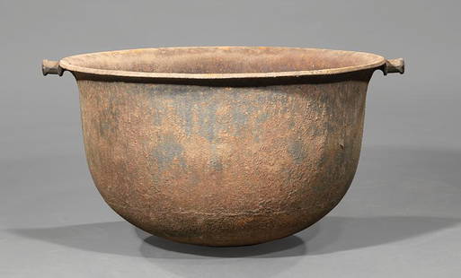
Sold2019Rare Plantation Cast Iron Sugar KettleRare Plantation Cast Iron Sugar Kettle, 19th c., rolled rim, two handles, h. 19 in., dia. 33 in . Provenance: Thomas Wilmot Klein, noted antiquarian, St. Francisville, LASee Sold Price
Sold2022Plan of St. Andrews Links Booklet with MapEarly booklet with folding map Plan of Golf Courses, showing Old, New and Jubilee Courses. Robert Forgan & Son, Scotland ad inside front cover. Early manuscript note verso. Rare book pocket map cartogSee Sold Price
Sold2021Manuscript Map of the Holy Land, early 18th Century[Manuscript map of the Holy Land] Pencil, ink, and watercolor on faux vellum with horizontal and vertical folding creases (8 segments) and no mounting guard; pencil grid visible in upper left and righSee Sold Price
Sold2022(MANUSCRIPT MAP -- CAPE TOWN.) Vue de Cap de Bonne Esperence.(MANUSCRIPT MAP -- CAPE TOWN.) Vue de Cap de Bonne Esperence. Pen and ink and watercolor wash on laid paper. 12¾x22¾ inches sheet size, ample margins; stain at right edge, backed with thin tSee Sold Price
Sold2022[MANUSCRIPT MAP-MAINE] CHADWICK, JOSEPH. Plan of part of the lands belonging to the Heirs of Brigd.r[MANUSCRIPT MAP-MAINE] CHADWICK, JOSEPH. Plan of part of the lands belonging to the Heirs of Brigd.r Waldo ... measured by Joseph Chadwick Nov.r 1765. [New England]: November, 1765. Manuscript surveySee Sold Price
Sold2022[MANUSCRIPT MAP-FLORIDA & MISSISSIPPI RIVER] Map Showing Raiford's Proposed Artificial River and[MANUSCRIPT MAP-FLORIDA & MISSISSIPPI RIVER] Map Showing Raiford's Proposed Artificial River and Plan to Continue the Western and Southern Inland System of Navigation to Harbors in the Atlantic. [FernSee Sold Price
Sold2022Ms. map of Potrero district SF 1865Heading: -1865 Author: Title: Map of Potrero Nuevo, San Francisco. May, 1865 Place Published: San Francisco Publisher: Date Published: 1865 Description: Ink manuscript map on arSee Sold Price
Sold202334 Civil War Related Papers and PhotosA fine collection of Civil War documents from 1861 - 1922. Highlighting the collection is a manuscript map in a contemporary hand showing a "Map of the route marched by 5th Regt P.R.v.C.(?) Starts inSee Sold Price
Sold2022Ms. map Outer Mission S.F. 1864Heading: -1864 Author: Potter, George C. Title: Manuscript map of the portion of San Francisco roughly bounded by Mission, 29th, Guerrero, and 26th streets Place Published: San Francisco Publisher:See Sold Price
Sold2016MAP OF NEW ENGLAND'Nova Belgica et Anglia Nova', by Willem Blaeu (1571-1663), hand-colored engraving, after a manuscript map by Adriaen Block, see Burden 241: 'First printed map that depicts canoes and North American fSee Sold Price
Sold2022Ms. map Outer Mission S.F. c.1880Heading: -1880 Author: Title: Manuscript map of the portion of San Francisco roughly bounded by Mission, 29th, Guerrero, and 25th streets Place Published: San Francisco Publisher: Date PublishedSee Sold Price
2 days LeftJasper52Anguilla St. Martin/Maarten Barts. Caribbean. US Navy sea chart 1899 (1917) map$300
2 days LeftForum AuctionsNapoleon family copy.- Mémoires pour servir a l'Histoire de France en 1815, first edition, from the£650
Oct 18Rail & Road Auctions1878 Maps of the New and Popular St. Louis and Texas Short Line Railroad Color Lithograph$40(1 bid)
2 days LeftForum AuctionsWindsor Castle, St George's Chapel.- Artificers Bills For Work Done For His Majesty In St. Georges£900
Oct 12JM Hobby Supply and Railroad Artifact AuctionsSt Paul and Chicago RY Statement of First Mortgage Fund Bonds-1867$30
Oct 12JM Hobby Supply and Railroad Artifact AuctionsPittsburg Cincinnati and St Louis RY 9/18/1877 Special Chicago Excursion Flyer$40
Oct 12JM Hobby Supply and Railroad Artifact AuctionsToledo St Louis and Kansas City RR First Mortgage Gold Bond-1887$10
Oct 12JM Hobby Supply and Railroad Artifact AuctionsSt Paul Minneapolis and Manitoba RY February 1885 Public Timetable$50
2 days LeftJasper52Large Civil War map of the United States. ETTLING. Illustrated London News 1861$300
Oct 17Rail & Road AuctionsInternational Silver Milwaukee Road Toothpick Holder and Double Handled Sugar Bowl$60
Oct 01DOYLE Auctioneers & AppraisersSouthern Interest: Group of American Coin Silver Mostly Southern, 19th century$400(1 bid)
2 days LeftForum AuctionsGolden Cockerel Press.- Bonaparte (Napoleon) Napoleon's Memoirs, 2 vol., one of 50 special copies,£2,400


![Manuscript Map of the Holy Land, early 18th Century: [Manuscript map of the Holy Land] Pencil, ink, and watercolor on faux vellum with horizontal and vertical folding creases (8 segments) and no mounting guard; pencil grid visible in upper left and righ](https://p1.liveauctioneers.com/1968/225974/116712048_1_x.jpg?height=310&quality=70&version=1636655147)

![[MANUSCRIPT MAP-MAINE] CHADWICK, JOSEPH. Plan of part of the lands belonging to the Heirs of Brigd.r: [MANUSCRIPT MAP-MAINE] CHADWICK, JOSEPH. Plan of part of the lands belonging to the Heirs of Brigd.r Waldo ... measured by Joseph Chadwick Nov.r 1765. [New England]: November, 1765. Manuscript survey](https://p1.liveauctioneers.com/292/250642/130213647_1_x.jpg?height=310&quality=70&version=1654271664)
![[MANUSCRIPT MAP-FLORIDA & MISSISSIPPI RIVER] Map Showing Raiford's Proposed Artificial River and: [MANUSCRIPT MAP-FLORIDA & MISSISSIPPI RIVER] Map Showing Raiford's Proposed Artificial River and Plan to Continue the Western and Southern Inland System of Navigation to Harbors in the Atlantic. [Fern](https://p1.liveauctioneers.com/292/250642/130213644_1_x.jpg?height=310&quality=70&version=1654271664)


![[CIVIL WAR] Soldier's Letter Re: Black Soldiers, Sugar & Cotton (1 of 3)](https://p1.liveauctioneers.com/7226/343679/186654957_1_x.jpg?height=282&quality=70&version=1726238840)

![[CIVIL WAR] Military Map of Sherman's March to the Sea (1 of 2)](https://p1.liveauctioneers.com/7226/343781/186766904_1_x.jpg?height=282&quality=70&version=1726333566)


![[CIVIL WAR ETC] LOT OF 20 PIECES OF EPHEMERA (1 of 3)](https://p1.liveauctioneers.com/8124/343618/186530067_1_x.jpg?height=282&quality=70&version=1726178725)


![[CIVIL WAR] Maryland Soldier's Bible (1 of 5)](https://p1.liveauctioneers.com/7226/343781/186766754_1_x.jpg?height=282&quality=70&version=1726333566)