Sold2022Plan of St. Andrews Links Booklet with MapEarly booklet with folding map Plan of Golf Courses, showing Old, New and Jubilee Courses. Robert Forgan & Son, Scotland ad inside front cover. Early manuscript note verso. Rare book pocket map cartogSee Sold Price
Sold2022From the London Magazine, Three 18th Century Maps: A New Chart of the Rover St. Lawrence from theFrom the London Magazine, Three 18th Century Maps: A New Chart of the Rover St. Lawrence from the Island of Anticosti...; A Plan of the River St. Lawrence from the Falls of Montmorenci to Sillery...;See Sold Price
Sold2019MONTEGRAPPA St. Andrews Links Fountain Pen 925 SterlingMONTEGRAPPA St. Andrews Links Fountain Pen Low Relief Sterling Silver. 18K Gold (750) nib. Limited Edition 176/700. Weight: 32.3 dwt / 50.3 gr. Made in Italy. Comes with ink, original box and papers.See Sold Price
Sold2022Leroy Neiman, Signed Serigraph, Old St. Andrews Links ClubhouseLeroy Neiman (1921 -2012) Serigraph, 'Old St. Andrews Links Clubhouse', 1987. Signed in black ink lower right and dedication lower middle. Measures: 23" x 28 3/4" (Sight) 30" x 36" (Framed)See Sold Price
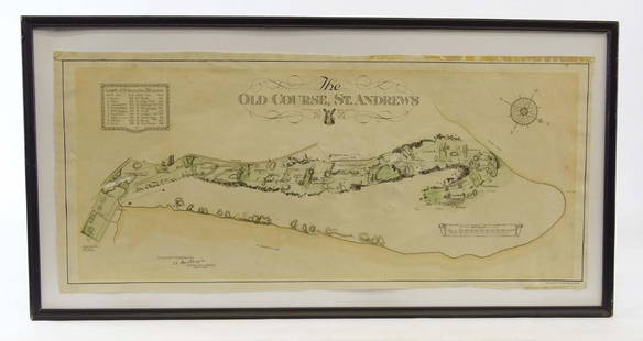
Sold2019Scotland Early Golf MapOld Course St. Andrews Map. Surveyed by A. MacKenize Architect, 1924. McCorquodale & Co., Glasgow, C. 1924. Sight 10 3/4" x 24 1/2".See Sold Price
Sold2021Charles Lee Color Engraving Golf St Andrews 1850Lee, after Charles (Scottish, 1800-1880), The Golfers: A Grand Match Played Over St. Andrew's Links, 1850, hand colored steel engraving by Charles E. Wagstaffe after the original oil painting by Lees,See Sold Price
Sold2019Early Golf PrintEarly framed golf print, The Golfers, St. Andrews Links. Arthur Ackerman & Son New York label verso. Sight 17" x 25".See Sold Price
Sold2022Tiger Woods Signed Souvenir Golf Score Card w/ COATiger Woods Signed Souvenir Golf Score Card from St. Andrews Links "The Old Course". Comes with COA. Condition: Good We truly believe that this item is authentic, but Esquis Auctions does not have speSee Sold Price
Sold2023Tiger Woods Signed St. Andrews British Open MapOwn a piece of golf history with this Tiger Woods Autographed "St. Andrews British Open" Course Map. Tiger Woods, one of the greatest golfers of all time, has left his signature on this iconic courseSee Sold Price
Sold2021India 1747 Antique Map Plan of Fort St. George & Madras"A Plan of Fort St. George and the City of Madras" Copper Engraved Map Published 1732-85, London for "The London Magazine" Paper Size: 8 x 5 inch (20 x 13cm) Very minor toning. Good ConditionSee Sold Price
Sold2020India 1747 Antique Map Plan of Fort St. George & Madras"A Plan of Fort St. George and the City of Madras" Copper Engraved Map Published 1732-85, London for "The London Magazine" Paper Size: 8 x 5 inch (20 x 13cm) Very minor toning. Good ConditionSee Sold Price
Sold2021St Andrews Old Course Golf ScorecardSt Andrews Old Course Golf Scorecard, inscriptions read ‘My Score at St. Andrews’, measures 6 1/4 inches tall x 3 3/8 inches wide, includes course map, sheet is not filled out, surface wear to pieSee Sold Price
Sold2021St Andrews Old Course Golf ScorecardSt Andrews Old Course Golf Scorecard, inscriptions read ‘My Score at St. Andrews’, measures 6 1/4 inches tall x 3 3/8 inches wide, includes course map, sheet is not filled out, surface wear to pieSee Sold Price
Sold2018Group of rolled maps and plans to include St.Group of rolled maps and plans to include St. Barthelemy Rockefeller Vacation House (32" x 36"), landscape sketch, site plans, Elevation plan, and full set of blueprints. Provenance: Estate of PeggySee Sold Price
Sold2023Collection of Assorted Golfing BooksCollection of Assorted Golfing Books. Including Legendary Golf Links of Ireland, Morris County Golf Club, St Andrews and Augusta National & The Masters. Used condition, wear, worn.See Sold Price
Sold2017Bellin: Antique Plan of St. Augustine, Florida, 1764Map: Plan du Port de St. Augustin dans la Florida Cartographer: Bellin Place & Date: Paris / 1764 Size: 6 1/4" x 8 1/2" Condition: outline color; very light age toning and minor spotting at outer edgeSee Sold Price
Sold2017SDUK, Map of St Petersburg, 1834Map: Saint Petersburg Maker: Society for the Diffusion of Useful Knowledge (SDUK) Date: 1834 Medium: Engraving Size: 12.75 x 15.25 inches A detailed plan of St Petersburg in 1834 naming most streets aSee Sold Price
Sold2017SDUK: Map of St. Petersburg, 1834St. Petersburg. The meticulously detailed Society for the Diffusion of Useful Knowledge plan of St. Petersburg, Russia, is centered on the Peter and Paul Fortress, with major thoroughfares and publicSee Sold Price
Sold2018Mitchell: Plan of St. LouisMap: St. Louis Cartographer: S. A. Mitchell Place & Date: Philadelphia / 1870 Size: 10 7/8" x 13 7/8" Condition: full color; light overall age toning The beautifully detailed and colored street plan oSee Sold Price
Sold20231764 Bellin Map of Castries in St. Lucia, Lesser Antilles -- Plan du Port du Carenage ou Petit CulTitle: 1764 Bellin Map of Castries in St. Lucia, Lesser Antilles -- Plan du Port du Carenage ou Petit Cul de Sac de l'Isle Se Lucie Cartographer: J Bellin Year / Place: 1764, Paris Map Dimension (in.)See Sold Price
Sold2023Map of St. Paul / Map of the City Of Fargo, Cass County, North DakotaTitle: Map of St. Paul / Map of the City Of Fargo, Cass County, North Dakota Cartographer: CRAM, GEORGE F. Publisher: GEO. F. CRAM Date: ©1904 Description: Seldom found city plan of Fargo. HeightSee Sold Price
Sold20221764 Bellin Map of Castries, St Lucia in Lesser Antilles -- Plan du Port et du Carenage de CariacouaTitle: 1764 Bellin Map of Castries, St Lucia in Lesser Antilles -- Plan du Port et du Carenage de Cariacoua Situe dans la Partie du Sud de l'Isle de St. Vincent Cartographer: J Bellin Date/Place: 1764See Sold Price
Sold2017La Perouse: Map of Port of San Diego, 1797Map: Plan du Port de St. Diego en Californie/Plan du Port et du Department de St. Blas Cartographer: La Perouse Place & Date: Paris / 1797 Size: 19 1/2" x 13 1/4" Plate 35 from the Atlas volume of LaSee Sold Price
2 days LeftRapid Estate Liquidators and Auction GalleryFramed Linda Hartough LE Litho Harbour Town Golf Links$525
2 days LeftRapid Estate Liquidators and Auction GalleryFramed Linda Hartough LE Litho British Open Championship$575
May 15University ArchivesDeclaration of Independence, Very Early British Publ. in Gentleman's Magazine & Rare Map$1,000
May 15University ArchivesFeb. 1777 Issue of The Gentleman's Magazine with Superb Map of Philadelphia$140(1 bid)
May 09Rail & Road Auctions1951 Chicago, Milwaukee, St. Paul & Pacific Railroad Wall Map - Route of the Hiawathas$50
May 10Rail & Road AuctionsGeneral Motors / Chevrolet Promotional Material - Proving Grounds, Little Six, Light Six, Motorama,$20(1 bid)
1 day LeftDoyle New YorkThe top sheet of the famous Ratzer Map - with additions relating to an 1810 real estate dispute$7,500
May 12Schilb Antiquarian Rare Books1883 FLORIDA for Tourists & Settlers Illustrated Fort Barrancas MAP Fine BINDING$78(5 bids)
May 09Rail & Road Auctions1896 Equipment Roster Record Booklet and Turn Of The Century Santa Fe Topeka Photos$30
May 09Rail & Road Auctions1901 Louisville and Nashville Railroad Dining Car Booklet and Childrens Menu$40
May 16Potter & Potter AuctionsLANGENECKERT. It’s A Dog’s World. 1968. St. Louis: Ralston ...$100
May 09Rail & Road AuctionsMilwaukee Road Gallatin Gateway to Yellowstone Color Advertising Poster$50(1 bid)
1 day LeftDoyle New YorkGoerck's 1785 working survey of the Common Lands that became Fifth Avenue$1,000
May 09Hunt and Peck Estate Services, Inc.1798 Bryan Edwards "The History Civil and Commercial of the british colonies in the west indies$50