Sold2022(2) 18th c. road maps, London-Norwich, etc.Two hand colored maps of roads from London to Norwich, England, and from Shrewsbury to Holywell, England. A printed description in an attached envelope on the back of one states that they were made bySee Sold Price
Sold20242 18th C. Road Maps: London to Carlisle (14 1/2" x 17 1/2") & Bristol to Exeter, 6 1/2"2 18th C. Road Maps: London to Carlisle (14 1/2" x 17 1/2") & Bristol to Exeter, 6 1/2"See Sold Price
Sold2023Map: An 18thC engraved strip / road map after John Owen and Emanuel Bowen, showing the road fromMap: An 18thC engraved strip / road map after John Owen and Emanuel Bowen, showing the road from London to Rochester via Deptford, Crayford and Dartford. Approx. 7 1/4" x 4 3/4"See Sold Price
Sold2022A framed 18th Century map of the road from London to Poole by John Ogleby 36 x 45 cm.A framed 18th Century map of the road from London to Poole by John Ogleby 36 x 45 cm.See Sold Price
Sold2022A framed 18th Century map of the road from London to Poole by John Ogleby 36 x 45 cm.A framed 18th Century map of the road from London to Poole by John Ogleby 36 x 45 cm.See Sold Price
Sold2015Period 18th Century Map of Switzerland.Period 18th century map of Switzerland. By A. Rouvier. 21" x 27-1/2" plate size. Published by John Rocque 1760, London. Size 29 -1/2" x 21 -1/4".See Sold Price
Sold201918TH CENTURY LONDON TO CARLISLE ROAD ENGRAVINGEnglish road map engraving by John Ogilby "London to Carlisle" from 1735. Measures 27.5" x 23" w/ frame.See Sold Price
Sold2016[Map] English Road Map18th century; watercolored, London to Barwick, framed 23 in. L., 19 in. H.See Sold Price
Sold20201761 MAP OF NORTH AMERICA BY ROCQUE18th century map GENERAL MAP OF NORTH AMERICA 1754-1761 by John Rocque, London by A. Drury, 2 part map, 35.5 x 36 inches, good condition.See Sold Price
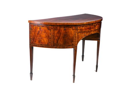
Sold2022GEORGE III ENGLISH MAHOGANY DEMI-LUNE SIDEBOARDFlame mahogany with satinwood banding, straight legs, with fitted central drawer, flanked by deep drawers. English, late 18th C. Old label from Norman Adams Ltd Hans Road London H. 37 1/2" W. 60" D. 2See Sold Price
Sold202218th & 19th C. MAPS OF ASIA (3 MAPS)Includes: 2 maps by John Tallis & Co. London / New York, ca. 1850, both matted and framed, including: (1) MAP OF ASIA. Hand colored engraved map. 5 hand colored vignettes. H. 10.25", W. 12.75"; (2) MASee Sold Price
Sold201918TH CENTURY LONDON TO HOLY HEAD ROAD ENGRAVINGEnglish road map engraving by John Ogilby "London to Holy Head" from 1735. Measures 27.5" x 23" w/ frame.See Sold Price
Sold2023Benjamin Cole, Map of Wards of LondonBenjamin Cole (English, 1695-1766), 18th century hand-colored engraving depicting the Baynards Castle Ward and Farringdon Ward, 14 1/2" x 18 1/2" sight size, 23 3/4" x 27 3/4" framed.See Sold Price
Sold2017EARLY NEW YORK STATE ACTUAL SURVEY MAPEARLY NEW YORK STATE ACTUAL SURVEY MAP FOR COUNTIES ALONG SUSQUAHANNAH RIVER, INCL. CLINTON, CHENANGO, GREEN, ETC. 18TH C. 15 1/2" X 21"See Sold Price
Sold2022Group of 11 Antique Maps11 maps, variously places in Europe, etc., published by Vicenzo Passini Carli, Sienna, Italy, late 18th Century. Hand-colored engravings. 15 3/4" x 11 1/2".See Sold Price
Sold2022After John OgilbyAfter John Ogilby After John Ogilby, 17th/18th century, 'The Continuation of the Road from London to Barwick', engraved and hand coloured road map, framed, 33 x 45.5cm Condition Report: Some visible cSee Sold Price
Sold2020Laurie & Whittle Map of AmericaLAURIE & WHITTLE (Late 18th Century)The United States of America...Engraved map with original hand color in full.London: Laurie & Whittle, 1794.20 1/4" x 22 1/2" sheet.The first British map to show thSee Sold Price
Sold2023Three Herman Moll maps of the West IndiesThree 18th century Herman Moll maps of the West Indieslot consists of three maps : 1. The Island of Jamaica, Divided into its Principle Parishes, with the roads etc. H. Moll Geographer; from Moll's AtSee Sold Price
Sold2023Antique Maps of Hertfordshire (2)Hertfordshire by Robert Morden. London, Early 18th C. With Hertfordiae Comitatus a cattifuclanis olim inhabitatus (Hertfordshire) by John Norden, engraved by William Kip, c. 1637. Largest 16" x 18 1/2See Sold Price
Sold2019Group of Books: T.A. Strange, French 17th-18th C.,Two books by T.A. Strange, a Guide to Collectors published by McCorquodal & Co, London; 1) French interiors furniture, decoration, etc. during the 17th and 18th centuries; 2) English furniture, woodwoSee Sold Price
Sold2018London.- Cruchley (George Frederick) New Map ExtendingLondon.- Cruchley (George Frederick) New Map Extending 24 Miles Round London, showing all the Mail, Turnpike, and Cross Roads, Gentleman's Seats, parks etc. etc. Also all the Proposed Railways, &c., cSee Sold Price
Sold20212 18th Century London Theatrical Broad Sheets, 10" x2 18th Century London Theatrical Broad Sheets, 10" x 15" & 9 1/2" x 7 1/2".See Sold Price
Sold2019(2) 18TH C. MAPSNetherlands. Dimensions: (Frame) H 32.25" x W 36", (Sight) H 22.5" x W 27" Condition: Wear consistent with age and handling. Toning, marks, and creases.See Sold Price
Sold2022(COLONIAL NORTH AMERICA.) Group of 3 small format 18th-century engraved maps.(COLONIAL NORTH AMERICA.) Group of 3 small format 18th-century engraved maps. London, vd - The Royal Magazine; G. Rollos, engraver. A New and Accurate Map of the Present Seat of War in North America.See Sold Price
6 days LeftCurated AuctionsA FINE MID 18TH CENTURY STERLING SILVER CHINOISERIE TEA CADDY, C. 1753£1,100
BonhamsTwo 18th century style silver salvers first Poston Products Ltd, Sheffield 1967, second C J Vand...£460(2 bids)
May 30NY Elizabeth 1704 AN ANTIQUE DETAIL OF EVERY SEAT IN THE CURRENT WARS OF EUROPE W/MAPS$50(1 bid)
Jun 02Tremont Auctions2 18th century English sterling silver armorial footed salvers. 1) 1778, London. Armorial engraving$150
BonhamsA pair of cast silver candlesticks, one with a three-light branch section R Comyns, London 1965 ...£440(1 bid)
5 days LeftJasper52Early 18th Century Antique George I Sterling Silver Tazza London 1722 Thomas Mason$4,400
5 days LeftJasper52Mid 18th Century Antique George II Silver Coffee/Milk Jug London 1759 William & James Priest$1,700
Jul 07A-1 Auction18th Century Large Portrait In the Style of Thomas Gainsborough 1727-1788$60(2 bids)
6 days LeftHannam's Auctioneers LtdA GOOD 18TH CENTURY ENGLISH LONGCASE CLOCK by William Trippett of London. 220 cm x 44 cm, dial 27 cm£260
5 days LeftHannam's Auctioneers LtdA FINE AND RARE PAIR OF LARGE 18TH CENTURY GEORGE III SILVER GILT REPOUSSE DISHES by Daniel Smith &£2,000
May 30NY Elizabeth 1792 OLD INDIA HISTORY ANTIQUE ILLUSTRATED WITH MAPS OF THE EIGHTEENTH CENTURY IN FRENCH$50
May 30NY Elizabeth 1709 SEPTUAGINT GREEK BIBLE ILLUSTRATED WITH MAPS, VINTAGE VELLUM BOUND VERSION$50(1 bid)
Jun 02Tremont Auctions18th century English sterling silver utensils. To include: 1) Pair of stuffing spoons. Engraved$250
5 days LeftJasper52Pair of 2 Vintage Prints wall hanging Framed Art 4 o'clock in Town 4 o'clock in Country Thomas$220
5 days LeftJasper521758 MAP PARTIE DE LA MER GLACIALE contenants La Nouvelle Zemble RUSSIA antique$55
Jun 02Tremont AuctionsDelft blue and white chinoiserie decorated vases, 17th/18th century. To include: 1) pair of vases$400(1 bid)


![[Map] English Road Map: 18th century; watercolored, London to Barwick, framed 23 in. L., 19 in. H.](https://p1.liveauctioneers.com/523/84219/43476550_1_x.jpg?height=310&quality=70&version=1453240168)