Sold2022A framed 18th Century map of the road from London to Poole by John Ogleby 36 x 45 cm.A framed 18th Century map of the road from London to Poole by John Ogleby 36 x 45 cm.See Sold Price
Sold2022A framed 18th Century map of the road from London to Poole by John Ogleby 36 x 45 cm.A framed 18th Century map of the road from London to Poole by John Ogleby 36 x 45 cm.See Sold Price
Sold2022After John OgilbyAfter John Ogilby After John Ogilby, 17th/18th century, 'The Continuation of the Road from London to Barwick', engraved and hand coloured road map, framed, 33 x 45.5cm Condition Report: Some visible cSee Sold Price
Sold20201761 MAP OF NORTH AMERICA BY ROCQUE18th century map GENERAL MAP OF NORTH AMERICA 1754-1761 by John Rocque, London by A. Drury, 2 part map, 35.5 x 36 inches, good condition.See Sold Price
Sold201918TH CENTURY LONDON TO HOLY HEAD ROAD ENGRAVINGEnglish road map engraving by John Ogilby "London to Holy Head" from 1735. Measures 27.5" x 23" w/ frame.See Sold Price
Sold201918TH CENTURY LONDON TO CARLISLE ROAD ENGRAVINGEnglish road map engraving by John Ogilby "London to Carlisle" from 1735. Measures 27.5" x 23" w/ frame.See Sold Price
Sold2021French School 18th Century Portrait of a NoblemanFrench School 18th Century Portrait of a Nobleman Oil on canvas 45 3/8 x 36 1/4 inches (115.3 x 92 cm) C Property of a Private Collector, London, Fifth Avenue and Southampton, New YorkSee Sold Price
Sold20242 18th C. Road Maps: London to Carlisle (14 1/2" x 17 1/2") & Bristol to Exeter, 6 1/2"2 18th C. Road Maps: London to Carlisle (14 1/2" x 17 1/2") & Bristol to Exeter, 6 1/2"See Sold Price
Sold2017Art - Venetian School (18th C.) Portrait YouthVenetian School, Portrait of a Youth, oil on canvas, unsigned, 24” x 18” (60.9 x 45.7 cm), inscribed on stretcher au verso “Bought in London by Gay Murchis, (St. Andrews by the Sea) and given bySee Sold Price
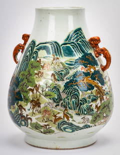
2023Rare Chinese Porcelain 'Hundred Deer' Vase18th/19th century; six-character seal mark in underglaze blue 17 3/4 x 14 1/4 in. (45.1 x 36.2 cm.) Provenance: Property from the Personal Collection of Beverly Hills Designer Barbara LockhartSee Sold Price
Sold2023Four 18th C. Elytra Beetle Wing Panels, IndiaFour 18th C. Elytra Beetle Wing Panels, India. Each border with iridescent green-blue beetle wing casings. Size: Unframed: 35.5'' x 5.5'', 90 x 14 cm (stretcher). Framed: 36'' x 6.25'', 91 x 16 cm (frSee Sold Price
Sold2015Two 18th C. Framed Asian MapsFrom "A Geography of the World," London 1768. One depicting a map of China, the other depicting a map of Asia. Framed behind glass, 14.5" H x 15.5" W.See Sold Price
Sold202218th C. John Senex Map of India and ChinaJohn Senex map, London, 1721, "A New Map of India & China", outlining the area, and including Japan, Malay Peninsula and Southeast Asia, unframed. [Sheet: 21 1/4" H x 25" W]. In distressed condition,See Sold Price
Sold202218TH-CENTURY MAP OF AFRICA18TH-CENTURY MAP OF AFRICA: John Senex "Africa Corrected from the Observations of the Royal Society of London and Paris", published 1714. Frame Approx. 29.25" h x 40.25" w.See Sold Price
Sold2017(18th c) EUROPEAN SCHOOL"The Offering" oil on canvas 44 x 36 inches. unsigned. framed 60 x 53 inches (overall)See Sold Price
Sold2020John Harris (British, 1686-1740)John Harris (British, 1686-1740) , "The Chapter House of the Cathedral Church of St Paul's London", 18th c., hand-colored engraving, sight 18 3/8 in. x 22 1/2 in., framed . Provenance: Estate of JamesSee Sold Price
Sold201818th C. Mezzotint Paulo PurgantPaulo Purganti and his Wife from Priors Poems. Printed for and sold by Carington Bowles at his Map and Print Warehouse #69 St. Paul's Church Yard, London. Framed. 13"H. x 9.75"W.See Sold Price
Sold2023Antique Maps of Hertfordshire (2)Hertfordshire by Robert Morden. London, Early 18th C. With Hertfordiae Comitatus a cattifuclanis olim inhabitatus (Hertfordshire) by John Norden, engraved by William Kip, c. 1637. Largest 16" x 18 1/2See Sold Price
Sold2016A rare Chinese Huang Huali altar table, 17/18thA rare Chinese Huang Huali altar table, 17/18th century 189 x 84 cm, 36 cm high<See Sold Price
Sold2018Arte Sud-Est Asiatico A meiping pottery vaseSouth-Est Asian Art A meiping pottery vase overpainted with cherry blossoming branches Korea, Joseon dynasty, 18th-19th century . . Cm 18,00 x 45,00. Provenance: Ex Alfio Nicolosi Collection, Mantova,See Sold Price
Sold2016Vasilij SUCHAEV (1887-1973) Russian - French - GeorgianVasilij Ivanovic Suchaev (1887-1973) ; Double portrait of Suchaev & Iacovleff (Alexander Evgenevich IACOVLEFF, 1887-1938) ; 1933 ; canvas on wood, oil / framed ; dimentions 45,5 x 36 cm (17.91 x 14.17See Sold Price
Sold2022An antique bronze bell mounted on a wood base. 18th C. (W:120 x H:52 x D:36 cm)An antique bronze bell mounted on a wood base. 18th century. Missing the bell-klapper. (W:120 x H:52 x D:36 cm)See Sold Price
Sold2022A pair of frames with copper repousse hunting scene, decorated with a tortoiseshell rim. 18th C.A pair of frames with copper repousse hunting scene, decorated with a tortoiseshell rim. 18th century. Sizes including the frame. (W:43 x H:36 cm)See Sold Price
Sold2021John Nieto, Matachine DancerJohn Nieto(1936 - 2018)Matachines Dancerpastel on papersigned lower right: nieto19 x 25 in. (48.26 x 63.50 cm.), Frame: 26 1/8 x 32 1/4 x 1 3/4 in. (66.36 x 81.92 x 4.45 cm.) From the John and Renay NSee Sold Price
6 days LeftMerrill's Auctioneers and AppraisersPair of Narrow Barrel Back Corner Cupboards$250(1 bid)
180 Lots AwaySan Rafael Auction GalleryContinental school painting, likely 18th C., Putti with Grapes$300(1 bid)
May 05Tremont Auctions18th century map of New Jersey. "A New and Accurate Map of New Jersey". W. Long, London. Map size 13$100
157 Lots AwaySan Rafael Auction GalleryC. 1768 English Sterling Silver Coffee Pot, Whipham & Wright$550(3 bids)
6 days LeftBright Star Antiques Co.Pair of 18th C. Spanish Doors w/ Custom Bases 81"H x 22 1/2"L ea.$75(2 bids)


![18th C. John Senex Map of India and China: John Senex map, London, 1721, "A New Map of India & China", outlining the area, and including Japan, Malay Peninsula and Southeast Asia, unframed. [Sheet: 21 1/4" H x 25" W]. In distressed condition,](https://p1.liveauctioneers.com/1221/258471/135401029_1_x.jpg?height=310&quality=70&version=1661963765)


