Sold2016[Map] English Road Map18th century; watercolored, London to Barwick, framed 23 in. L., 19 in. H.See Sold Price
2019Early English road map by John OgilbyHeading: (Maps) Author: Ogilby, John Title: The Road from London to St. Neotts in Com. Hunt. Continued to Oakeham in Com Rutland Place Published: London Publisher: Date Published: 1675See Sold Price
Sold20231736 English Road Maps Cambridge, Bath-Bristol, Lancaster- York & Knaresburg1736 Cambridge hand colored 5 x 7 in frame, Lancaster and York, Knaresburg 2 sided in open matt 5 x 7, and Bath to Bristol framed 4 x 6 inches in matt.See Sold Price
Sold2022Rare Late 1700's English Road Mapsc.1790 English hand-colored road maps, published by J. Cary, showing inns & pubs along the road. Lewisham to turnbridge Wells. Includes Lee, Eltham, Farningham & Maidstone etc. Maps on both front & baSee Sold Price
Sold201918TH CENTURY LONDON TO HOLY HEAD ROAD ENGRAVINGEnglish road map engraving by John Ogilby "London to Holy Head" from 1735. Measures 27.5" x 23" w/ frame.See Sold Price
Sold201918TH CENTURY LONDON TO CARLISLE ROAD ENGRAVINGEnglish road map engraving by John Ogilby "London to Carlisle" from 1735. Measures 27.5" x 23" w/ frame.See Sold Price
Sold2022Thomas Gardner, English Hand Colored Road MapDepicting the roads from Exeter to Dorchester and from Plymouth to Dartmouth, inscribed to the honorable Nathaniel Napier, originally published in 1719. Nicely hand colored and framed. Sight size: 7"See Sold Price
Sold2022Pair of English Map Plates, by Ogilby.Artist: John Ogilby. Title/Subject: "The Road from Hereford to Leicester"; and "The Continuation of the Road from Chester to Cardiff com. Glamorgan." Size: Each 15in x 19in; 16 3/4in x 20 1/2in (frameSee Sold Price
Sold20174 English Maps & EngravingsFour (4) English maps and engravings, including Ogibly, Speed, Chavane. 1st item: "98. The Road from Shrewsbury to Chester to Holywell Co. Flint.", by John Ogilby (United Kingdom, 1600-1676), from hisSee Sold Price
Sold2022Antique Map of Europe - County Map of Glamorganshire - Wales - United KingdomAntique map of Glamorganshire. Place names, topography, roads and railways are shown in significant detail by Joshua Archer. 'The Universal English Dictionary ...' by Rev. James Barclay, published inSee Sold Price
Sold2022Antique Map of Europe - County Map of Huntingdonshire - Wales - United KingdomAntique map of Huntingdonshire. Place names, topography, roads and railways are shown in significant detail by Joshua Archer. 'The Universal English Dictionary ...' by Rev. James Barclay, published inSee Sold Price
Sold2022Antique Map of Europe - County Map of Herefordshire - Wales - United KingdomAntique map of Herefordshire. Place names, topography, roads and railways are shown in significant detail by Joshua Archer. 'The Universal English Dictionary ...' by Rev. James Barclay, published in LSee Sold Price
Sold20201798 1ed Cary ROADS New Itinerary England Wales1798 1ed Cary ROADS New Itinerary England Wales Topography Atlas Travel Guide John Cary was a famous English cartographer from the 18th-century. Cary gained his reputation as a map maker from his workSee Sold Price
Sold20211930s Southern California Map -- Road Map SouthernTitle: 1930s Southern California Map -- Road Map Southern section of California Cartographer: Automobile Club of Southern California Year / Place: mid 1930s, Los Angeles Map Dimension (in.): 16.8 X 31See Sold Price
Sold2020Road Map of New MexicoTitle/Content of Map: Road Map of New Mexico Date: 1936 Cartographer: GOUSHA, H. M. CO. Publisher: STANDARD OIL COMPANY OF TEXAS Size: 23Height - 17Width Full color road map. Entire US on reverse. CovSee Sold Price
Sold2022VINTAGE NORTH EASTERN US & FRENCH ROAD MAPSVINTAGE NORTH EASTERN US & FRENCH ROAD MAPS Road maps of the eastern seaboard of PA, NY, D.C., VA, MD, and NJ by AAA and Exxon. Also included are five Michelin maps of France.See Sold Price
Sold2024Keith Haring Artwork Signed on a Shell Oil New York Road Map 18 in. x 24 in.Keith Haring Artwork Signed on a Shell Oil New York Road Map 18 in. x 24 in. size: 18 x 42 open - rippingSee Sold Price
Sold2022Antique 1719 English Map of the Chesapeake Bay by John SenexAntique early English map of the Chesapeake Bay, showing the principal settlements of this tobacco and cotton producing region. Engraved in London in 1719 by John Senex map is titled The Sea of VirginSee Sold Price
Sold2021Early English map of U.S. 1783Heading: Author: Kitchin, Thomas Title: Map of the United States in North America: with the British, French and Spanish Dominions adjoining, according to the Treaty of 1783. Place Published: London PSee Sold Price
Sold2022HUSKY GASOLINE SERVICE STATION MAP DISPLAY W/ HUSKY ROAD MAPS.SST. An excellent and complete example of this Circa 1950's Service Station Road Map Display from Husky showing a Tin Husky Sign at the face and complete with Maps. CONDITION: Display is in overall exSee Sold Price
Sold2022New road map of the city of Paris 1839 Rosselin editeur engravingNouveau plan routier de la ville de Paris, Guide exacte de cette capitale : en 12 arrondissemens avec leurs mairies et en 48 quartiers, 1839V. ROSSELIN (19th century), print editor, Paris, EstablishedSee Sold Price
Sold2022British road maps.- Ogilby (John) The Roads fromNO RESERVE British road maps.- Ogilby (John) The Roads from Chelmsford in Essex to St. Edmonds-Bury in Suffolk & Saffron-Walden in Essex, strip road map, engraving with hand-colouring, on thin laid paSee Sold Price
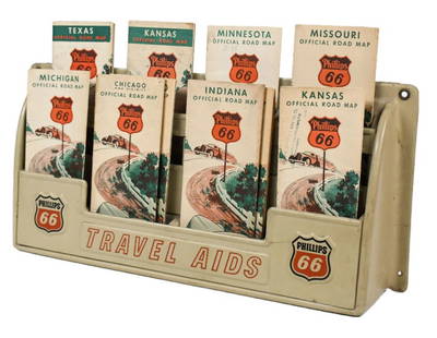
Sold2023Vintage Phillips 66 Road Map Embossed Display RackVintage Phillips 66 embossed plastic road map display rack full with original 1930s Phillips 66 maps. Rack has discoloration, some expected chips/ cracks, and wear from use and age. Displays well withSee Sold Price
May 17Ni-Cola Classics - Automobilia Auction & Classic Car SalesAutomobilia Road map 'Inverno-Primavera 1937-XV'€50
May 09Rail & Road Auctions1961 Chicago, Milwaukee, St. Paul & Pacific Railroad Polychrome Wall Map$50
May 09Hunt and Peck Estate Services, Inc.William Hole "A Description of the land of Gosen, and Moses passage though the Deserts"$50
May 09Rail & Road Auctions1951 Chicago, Milwaukee, St. Paul & Pacific Railroad Wall Map - Route of the Hiawathas$50
1 day LeftMichael Scarola Rare and Used BooksMilitary Wagon-Road In Wyoming And Montana Territories With Map Of Military Reconnaissance 1873-4$100
May 09Rail & Road AuctionsMilwaukee Road Gallatin Gateway to Yellowstone Color Advertising Poster$50(1 bid)
May 09Rail & Road Auctions1882 New York, Ontario and Western / New York West Shore and Buffalo Railroad Map$40
May 09Rail & Road AuctionsChicago, North Shore & Milwaukee Railroad North Shore Line Playing Cards Complete$50
May 10Rail & Road AuctionsThree Canadian Pacific Airlines Advertising Lighters - Zenith, Madison, and Coronet$25(2 bids)
May 10Rail & Road Auctions1906 True Bearing of Celestial Objects for The Great Lakes Book and 1957 The Heavens Map From$20


![[Map] English Road Map: 18th century; watercolored, London to Barwick, framed 23 in. L., 19 in. H.](https://p1.liveauctioneers.com/523/84219/43476550_1_x.jpg?height=310&quality=70&version=1453240168)
![[Map] English Road Map First Image](https://p1.liveauctioneers.com/523/84219/43476550_1_x.jpg?height=300&quality=1&version=1453240168&width=300)
![[Map] English Road Map First Image](https://p1.liveauctioneers.com/523/84219/43476550_1_x.jpg?height=300&quality=95&version=1453240168&width=300)