Sold20162 Early Maps of PennsylvaniaDESCRIPTION: Two early maps of Pennsylvania. Includes: 1) 1805 handcolored engraved map by John Carey in two parts. 17" x 21-1/4". Hinged at center. Small pinhole to York County. Light edge toning. CoSee Sold Price
Sold2017Bradford: Antique Map of Pennsylvania, 1838Title/Content of Map: Pennsylvania by Bradford Date Printed: 1838/1841 Cartographer: Thomas G. Bradford Material/Medium: Paper Size: 16 1/2" x 13" Hand colored. A General Atlas of the World with a SepSee Sold Price
Sold2017Bradford: Antique Map of Argentina Chile Paraguay, 1835Title/Content of Map: Early Map of Argentina, Chile, Paraguay & Uruguay Date Printed: 1835 Cartographer: T. G. Bradford Material/Medium: Paper Size: 9 1/2" x 12" A Comprehensive Atlas Geographical, HiSee Sold Price
Sold2017LOT (3) EARLY POCKET BOOK MAPS C.1830'sLOT (3) EARLY POCKET BOOK MAPS INCL. H/C STATE OF NEW YORK BY HUMPHREY PHELPS,1833, 16" X 21", STATE OF NEW JERSEY BY J. LOW, C. 1830, 10 1/2" X 7 1/2", STATE OF PENNSYLVANIA BY A. FINLEY, C. 1830, 9"See Sold Price
Sold2017Bradford: Antique Map of Iowa & Wisconsin, 1838Title/Content of Map: Rare and Important early Iowa and Wisconsin Date Printed: 1838/1841 Cartographer: Thomas G. Bradford Material/Medium: Paper Size: 13" x 16 1/2" Hand colored. A General Atlas of tSee Sold Price
Sold20232 Malham's Naval Gazetteer MapsTwo early 19th century Malham's Naval Gazetteer engraved maps with hand-coloring. Includes "A Correct Chart of the West Indes" and "A Correct Chart of the Coasts of South America". Both dated "1801" uSee Sold Price
Sold2023Three Different Early Pennsylvania Turnpike Road Stocks [165868]Lot of 3 different. 1) Centre Turnpike Road, leading from Reading to Sunbury. Issued for one share to the Commonwealth of PA in 1821. Signed by president Bradford and treasurer Boyd. 3.75 x 6" 2) CentSee Sold Price
Sold2023French map of North America published by Bonne 1781 sea of the westRigobert Bonne (6 October 1727 – 2 September 1794) work represents an important step in the evolution of the cartographic ideology away from the decorative work of the 17th and early 18th centurSee Sold Price
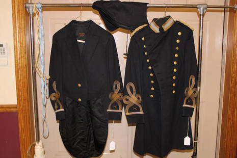
Sold20202 Early West Point Cadet Coats and Hood2 early West Point cadet coats and hood of Bartholf estate, descendant of Alexander Hamilton.See Sold Price
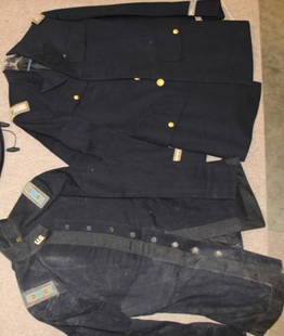
Sold20202 Early West Point Cadet Coal and Epaulette2 early West point cadet coal and epaulette of Bartholf estate, descendant of Alexander Hamilton.See Sold Price
Sold20172 early maps, Chili & Auriacus Princip, by Ortelius.2 Antique Hand-Colored Map Prints, "Royaume de Chili", a miniature map of Chili, South America ; and "Auriacus Principatus" ( by Ortelius), showing the region around the Roman city of Orange in southeSee Sold Price
Sold2023(5) Children's Sports Theme LunchboxesIncludes three sport skwirts, an NFL, and a playball lunchboxes. Includes Davy Crockett, Zorro, Wild Frontier, & (2) Early West (Oregon Trail/Indian Territory) Lunchboxes. All show some signs of wearSee Sold Price
Sold2024Two Early Maps of West Germany and the Gulf of Pozzuoli in Italy by Blaeu (Amsterdam, 1643-1704)Two Early Maps of West Germany and the Gulf of Pozzuoli in Italy by Blaeu (Amsterdam, 1643-1704) Including "Le Golfe de Pouzol, est une partie du golfe de Naples elle est vers la Ville du Pouzol & lesSee Sold Price
Sold20202 Early American West P. O. C. PhotosLeft: "Santa Fe Indians and Blacks. 8 x 11". Right: "Negro and Hispanic ranch hands 1914".See Sold Price
Sold20212 Early Estate Maps2 early estate maps. Hand colored all over with frame. 17" wide, 23" tall.See Sold Price
Sold2021Lot of 2 Early Petroliana PA PhotographsLot of 2 Early Petroliana Pennsylvania Photographs - 1 of 'Socony Auto Supplies" & 1 of Early Automobiles w/Provenance on the Back, Both in VG Cond., Both Photo Sz.- 6x8in.See Sold Price
Sold2017Map LotLot (2) early mounted maps. Includes New York (30 1/2" x 22 1/2") and County of Essex (30 1/2" x 22 1/2").See Sold Price
Sold2022(on 2) EARLY CONTINENTAL COLORED MAPSHISPALENSIS CONVENTUS DELINE ATIO/ Auctore Hieronymo Chiaues dated 1579, (modern day Andulusia, Spain); 13.5 by 18 in. (sight); framed, 20 by 24.5”; along with large folio map of France GALLIAESee Sold Price
Sold20232 EARLY FRAMED PRINTS "WEST POINT & BARCLAY IRON"WEST POINT & BARCLAY IRON WORKSSee Sold Price
Sold2024THREE SCARCE CIRCA 1900 FIGURAL CAST IRON STILL BANKS1. A 'Clock Bank' in the form of a circa 1900 jeweler's street clock on an ionic column, attributed to the maker Dent Hardware Company, Pennsylvania. 2. Early traffic light figural cast iron bank. 3.See Sold Price
Sold2018West IndiesReserve Reduced! Title/Content of Map: West IndiesDate: 1835 Cartographer: Bradford, T.G. Material/Medium: William D. Ticknor Size: 7.6 x 9.75 inches Map showing countries separately outline colored.See Sold Price
Sold2024Artwork LotLot (7) pieces of artwork including 19th c. Currier and Ives "Little Brothers" (overall 16 1/2" x 12 1/2"), early New Jersey map, framed "STAMPS OF MEDICINE", framed 1853 Boston Newspaper etc..See Sold Price
7 days LeftEast Coast Fine Arts LLCAttrib Benjamin West Penelope Waken By Eurykleia After Angelica Kaufmann$4,000
BonhamsSTIRRUP (THOMAS) Horometria: Or the Compleat Diallist: Wherein the Whole Mystery of the Art of D...£10(1 bid)
14 hrs LeftMaterial CultureWest Anatolian Yuncu Kilim, Turkey, Early 19th C., 4'2'' x 8'2''$1,000(1 bid)
Featured2 days LeftJasper521863 Johnson & Ward Map of the United States -- Johnson's New Military Map of the United States$140
Jul 06Case Antiques, Inc. Auctions & Appraisals32 Handmade Transparent Swirl Glass Marbles$175(2 bids)


![Three Different Early Pennsylvania Turnpike Road Stocks [165868]: Lot of 3 different. 1) Centre Turnpike Road, leading from Reading to Sunbury. Issued for one share to the Commonwealth of PA in 1821. Signed by president Bradford and treasurer Boyd. 3.75 x 6" 2) Cent](https://p1.liveauctioneers.com/2699/291513/154446047_1_x.jpg?height=310&quality=70&version=1685892308)