Sold2024Scarce Georgia-Alabama Civil War-era RR map by Johnson & Browning, 1861Johnson’s Georgia and Alabama from the scarce 1861 edition of Johnson’s Family Atlas published shortly after the outbreak of the war in 1861 by Johnson & Browning. Shows network of railroaSee Sold Price
Sold20181864 Johnson Map of the United States -- Johnson'sTitle/Content of Map: 1864 Johnson Map of the United States -- Johnson's United States Date: 1864, New York Cartographer: A Johnson Size: 16.9 x 23.1 in. This is a large, highly detailed Civil War eraSee Sold Price
Sold2022Significant United States map, 1864 Johnson & WardVery interesting hand-colored map created at a pivotal time in the settlement of the American West. In this lovely Civil War era map many of the western states have still not settled their borders. ArSee Sold Price
Sold2017Johnson’s Civil War era map of North & South CarolinaHistoric map shows the Carolinas in great detail shortly following the outbreak of the Civil War. States hand-colored at the time of publishing with color coding according to county. Inset map depictsSee Sold Price
Sold2023Great Civil War era RR map of Kentucky & TennesseeA map produced toward the end of the Civil War, it oddly features two states who wound up fighting against each other. Tennessee, for its part, had more fighting than any other state other than VirginSee Sold Price
Sold2021Civil War era map of Iowa & Missouri, 1861/66Title: Civil War era map of Iowa & Missouri, 1861/66 Description: Vintage map of Iowa and Missouri showing the states at the time of the Civil War. Although the map came from an 1866 edition of MitcheSee Sold Price
Sold2021CIVIL WAR-ERA JOHNSON'S MILITARY MAP UNITED STATESFramed engraving with color on paper, "Johnson's New Military Map of the United States, Showing the Forts, Military Posts & c., with Enlarged Plans of Southern Harbors from Authentic Data Obtained atSee Sold Price
Sold2022Louisiana & Alabama with Mississippi, 1864 scarce publication by SchonbergTitle: Louisiana & Alabama with Mississippi, 1864 scarce publication by Schonberg Date/Period: 1864 Materials: Hand colored steel plate engraved. Size: 14 x 12 inches 1864 uncommon civil war era map bSee Sold Price
Sold2022Title page of Schonberg’s 1864 atlas, 1864 scarce publication by SchonbergTitle: Title page of Schonberg’s 1864 atlas, 1864 scarce publication by Schonberg Date/Period: 1864 Materials: Hand colored steel engraved Size: 14 x 12'' 1864 uncommon civil war era map by SchoSee Sold Price
Sold2022llinois & Ohio with Indiana, 1864 scarce publication by SchonbergTitle: llinois & Ohio with Indiana, 1864 scarce publication by Schonberg Date/Period: 1864 Materials: Hand colored steel plate engraved. Size: 14 x 12 inches 1864 uncommon civil war era map by SchonbeSee Sold Price
Sold2022Germany & Austrian Empire 1864. Scarce publication by SchonbergTitle: Germany & Austrian Empire 1864. Scarce publication by Schonberg Date/Period: 1864 Materials: Hand colored steel engraved Size: 14 x 12'' 1864 uncommon civil war era map by Schonberg, New York.See Sold Price
Sold2022Prussia with Saxony & Switzerland 1864. Scarce publication by SchonbergTitle: Prussia with Saxony & Switzerland 1864. Scarce publication by Schonberg Date/Period: 1864 Materials: Hand colored steel engraved Size: 14 x 12 inches 1864 uncommon civil war era map by SchonberSee Sold Price
Sold2019Civil War era Johnson's Family Atlas, 1864Heading: Author: Johnson, A. J. and J. H. Colton Title: Johnson's New Illustrated (Steel Plate) Family Atlas, with Physical Geography, and with Descriptions, Geographical, Statistical, and HistoricalSee Sold Price
Sold20241862 Civil War-era map of Alabama/Georgia, Johnson & WardJohnson’s Georgia and Alabama from the 1862 edition of Johnson’s Family Atlas published during the second year of the war in 1862 by Johnson & Ward. Shows railroads operating at the beginnSee Sold Price
Sold2020Early Civil War era map of AmericaNice example of A. J. Johnson's 1862 map of North America. Presents a fascinating snapshot of North America just after the outbreak of the American Civil War. States generally follow the 1861 configurSee Sold Price
Sold2024Civil War era map of N. America with unsettled state bordersOne of the key maps in the 1860s Johnson series of North America. In this map Idaho Territory encompasses what would eventually become Idaho, Montana and Wyoming. Dakota Territory has yet to split intSee Sold Price
Sold2023Civil War era map of N. America with unsettled state bordersOne of the key maps in the 1860s Johnson series of North America. In this map Dakota Territory has yet to split into its north and south divisions while it stretches to encompass what will eventuallySee Sold Price
Sold2022Civil War era map of N. America with unsettled state bordersOne of the key maps in the 1860s Johnson series of North America. In this map Idaho Territory encompasses what would eventually become Idaho, Montana and Wyoming. Dakota Territory has yet to split intSee Sold Price
Sold202319th century. A hand-colored American Civil War era map of Virginia, Delaware, Maryland, and West19th century. A hand-colored American Civil War era map of Virginia, Delaware, Maryland, and West Virginia. Published by A.J. Johnson New York USA. Marked as page 47. Overall good condition; some browSee Sold Price
Sold20241864 Map of Virginiaprinted at the Coast Survey Office. A.D. Bache Supdt. Civil War era railroad map. Framed and under glass. Overall size is 27" x 41" Map has some creases from being folded and stains.See Sold Price
Sold2019United States. Civil war era military map. ShowingTitle/Content of Map: United States. Civil war era military map. Showing southern ports Date: 1863 Cartographer: By Johnson & Ward. From, Johnson’s New Illustrated Family Atlas Size: 18x 26 1/4”.See Sold Price
Sold202419th C. Johnson’s Florida Map1863 Civil War era colored map of Florida by Alvin Jewett Johnson, published by A.J Johnson New York. Unframed in protective sleeve. Measures just shy of 14 inches by 18 inches.See Sold Price
Sold2023FRAMED 19TH C. JOHNSON'S FLORIDA MAP1863 Civil War Era Colored Map of Florida, by Alvin Jewett Johnson (1827-1884), published by Johnson & Ward, New York, in a gilded and green painted wooden frame with mat, glazed, OS: 19 1/2" x 23 1/2See Sold Price
Sold2022Exceptional 1864 RR map of Texas, S. A. Mitchell, Jr.One of the most attractive atlas maps of Texas to appear in the mid-19th century. This nearly 160-year-old map--published during the height of the Civil War--shows the region from western New Mexico tSee Sold Price
23 hrs LeftLakeshore Event CenterEphemera, Civil War Generals, Abraham Lincoln, Ulysses Grant, Lot of 3$62(2 bids)
Jul 07Case Antiques, Inc. Auctions & Appraisals3 Civil War Era Photos, incl. Rose O'Neal Greenhow, poss. Jeff Davis$150
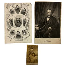
Featured5 days LeftUniversity ArchivesAbraham Lincoln PSA GEM MT 10 CDV, Signed 3 Weeks Before His Death.$30,000(1 bid)
2 days LeftSchilb Antiquarian Rare Books1918 Robert E Lee Civil WAR Confederate General CSA Battles MAPS Illustrated$62(6 bids)
2 days LeftSchilb Antiquarian Rare Books1890 1ed Confederate Memoirs of Joseph Johnston & Jefferson Davis Civil War CSA$66(3 bids)
Featured5 days LeftUniversity ArchivesCapture of Jefferson Davis: “Mr. Davis tried to escape…with a ladies waterproof$1,600
Jul 14Schilb Antiquarian Rare Books1928 Life of Abraham Lincoln 1ed SLAVERY Civil War Albert Beveridge 2v SET$1(1 bid)
1 day LeftActivity AuctionsJefferson Davis Autograph Signed Civil War Confederate President Framed (JSA LOA)$1,400
6 days LeftSwann Auction Galleries(CIVIL WAR--CONFEDERATE.) A late issue of the Daily Constitutionalist, one of the last Confederate$450
6 days LeftSwann Auction Galleries(ABRAHAM LINCOLN.) [Alexander Gardner], photographer. Carte-de-visite "inkwell portrait" of the$1,500
Jul 04Weatherham Estate TreasuresAbraham Lincoln Bronze Bust Sculpture On Marble Base - Signed Original - 10lbs$400
5 days LeftUniversity ArchivesIconic U.S. Grant Battlefield Albumen by Mathew Brady at City Point During Siege of Petersburg$400
Jul 14Schilb Antiquarian Rare Books1885 Civil War 1ed Memoirs of Union General Ulysses S. Grant Illustrated MAPS 2v$135(7 bids)
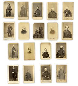
5 days LeftUniversity Archives18 pc. CDV Archive of Civil War Generals Incl. Many Brady & E. Anthony Examples$260(1 bid)
Jul 06Case Antiques, Inc. Auctions & AppraisalsCivil War Veteran GAR Uniform, PVT Stephen F. Oliver$200(1 bid)
2 days LeftSchilb Antiquarian Rare Books1860 Political Textbook 1ed SLAVERY Abe Lincoln Douglass Civil War Government$74(4 bids)


![(ABRAHAM LINCOLN.) [Alexander Gardner], photographer. Carte-de-visite "inkwell portrait" of the (1 of 1)](https://p1.liveauctioneers.com/199/334052/180497937_1_x.jpg?height=282&quality=70&version=1718909401)