Sold20201796 Geography MAPS English Travel Brookes Gazetteer1796 Geography MAPS English Travel Brookes Gazetteer Civil War Provenance Richard Brookes’ ‘General Gazetteer’ is an 18th-century encyclopedia-like work focusing on geography of the world. OrganSee Sold Price
Sold2018World Map - Hand-Colored Engraving - England, 17thA Mapp or Generall Carte of the World Designed in two Plaine Hemisphers, by Monsieur Sanson Geographr to the French King and Rendered into English and Illustrated with Figures by Richard Blome By theSee Sold Price
Sold20191800 Geography ATLAS MAPS John Walker India Asia World1800 Geography ATLAS MAPS John Walker India Asia World Map John Walker’s ‘Elements of Geography’ is an incredibly late 18th-century English atlas known for its impressive folding maps. This atlaSee Sold Price
Sold20201883 Decisive Battles of the World Beautiful Marathon1883 Decisive Battles of the World Beautiful Marathon Waterloo Illustrated MAPS Edward Shepherd Creasy was an English historian and jurist, whose best-known work was ‘Fifteen Decisive Battles of theSee Sold Price
Sold20211876 Proctor ASTRONOMY Other Worlds than Ours PLANETS1876 Proctor ASTRONOMY Other Worlds than Ours PLANETS Mars Jupiter Meteors Richard Proctor was a 19th-century English astronomer known for his studies on the planets in the solar system as well as theSee Sold Price
Sold20181797 Atlas MAPS Brookes General Gazetteer Geography1797 Atlas MAPS Brookes General Gazetteer Geography Dictionary Asia America Richard Brooke’s ‘General Gazetteer’ is a dictionary-style book that is filled with world geographical terms describinSee Sold Price
Sold20241766 Atlas MAPS Brookes General Gazetteer Geography Dictionary Asia America1766 Atlas MAPS Brookes General Gazetteer Geography Dictionary Asia America Richard Brookes General Gazetteer is a dictionary-style book that is filled with world geographical terms describing EnglishSee Sold Price
Sold20191858 Lander Journal of Niger River Exploration AFRICA1858 Lander Journal of Niger River Exploration AFRICA Illustrated MAPS Canoes 2v Richard Lander was an English explorer who made his name for his voyages into Africa. After nearly a decade of AfricanSee Sold Price
Sold2020RARE world mapTitle: RARE world map Date/Period: 1596 Materials: Copperplate engraved Size: 14" x 10 1/4" Christ is shown on the left. The only world map of the century to show this. South America shows the westernSee Sold Price
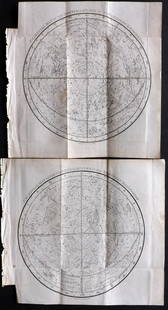
Sold2024Rare Celestial Map - Uranographia Britannica - John Bevis - Star ChartMap from John Bevis’s (1695-1771) legendary Uranographia Britannica [c. 1748], a celestial atlas of both high astronomical ambition and artistic beauty which was never formally published, its engravSee Sold Price
Sold2018Extremely Rare world map in double HemisphereTitle/Content of Map: Extremely Rare world map in double Hemisphere projection Date: 1717 Size: 7.6x10.6†by Feuille published in 1717, Amsterdam. With California as a island. from one of the mostSee Sold Price
Sold2024English World Map Globe Cocktail / Bar CartEnglish World Map Globe Cocktail / Bar Cart c.1950's - 40 in tall x 28 inch diameterSee Sold Price
Sold2018Zurner: Antique Map of the World, 1700Title/Content of Map: World Map by Zurner Date Printed: c1700 Cartographer: A.F. Zurner Material/Medium: Paper Size: 20" x 21" Rare world Map. Hand colored engraved. Please note that this lot has a coSee Sold Price
Sold2024English Mahogany World Map Coffee Table c.1950'sEnglish Mahogany World Map Coffee Table c.1950's - 14.5 in tall x 52.5 x 27See Sold Price
Sold2020Arrowsmith, Aaron 1825 Rare World Hemisphere Map"World on Globular Projection" Steel Engraved Map Published 1825, London for "Outlines Of The World" by Aaron Arrowsmith. Rare. Outline hand color. Paper Size: 15 x 10.5 inch (37 x 27cm) Top margin slSee Sold Price
Sold2021Phillips, Richard 1822 Celestial Map (2) ConstellationsCopper Plates Published 1822, London for "The Wonders of the Heavens Displayed, in Twenty Lectures" by Richard Phillips. Paper Size: 8.5 x 8 inch (22 x 21cm) Folds as issued. Very minor toning. Good CSee Sold Price
Sold2023Assorted Maps on Europe & the Sub ContinentAssorted maps on Europe, Scandinavia, and the Sub Continent, including Celestial and World Maps, some old and hand colored, some modern and picture reproductions. Provenance: Phyllis Lucas Gallery, NYSee Sold Price
Sold2021Lochhead (Pub) 1811 Rare Map. World HemisphereCopper Engraved Map Published 1811 by William Lochhead, Berwick for "Modern Geography: And a Compendious General Gazetteer" Rare. Folds as issued. Paper Size: 17 x 11 inch (43 x 28cm) Some creasing. VSee Sold Price
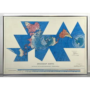
Sold2023Richard Buckminster Fuller Dymaxion World Map Print, 1980 FullerRichard Buckminster Fuller Dymaxion World Map Print, 1980 Fuller Dimensions: H: 22.5 inches: W: 34.5 inches --- -- We offer curbside delivery to NYC, Manhattan, Close Brooklyn, Hoboken about a week afSee Sold Price
Sold20221625 PURCHAS HIS PILGRIMES antique in ENGLISH WORLD'S HISTORY rareHaklvytvs posthumus, or, Pvrchas his Pilgrimes : contayning a history of the world, in sea voyages, & lande-trauells [London, Imprinted for H. Fetherston, 1625.] Folio. Size 8 1/2 by 12 1/2" DefectiveSee Sold Price
Sold2023Lizars, Daniel 1831 LG Rare HC Map. World on Mercator's ProjectionLarge Folio Copper Engraved Map Published 1831-2 by John Hamilton, Successor to Daniel Lizars, Edinburgh for "The Edinburgh Geographical and Historical Atlas..." First Edition by Daniel Lizars. Very fSee Sold Price
Sold2021Turner, Richard 1808 Map. World HemispheresCopper Engraved Map Published 1808, London for "A New and Easy Introduction to Universal Geography..." by the Rev. Richard Turner. Folds as issued. Paper Size: 10.5 x 5.5 inch (27 x 14cm) A couple ofSee Sold Price
Sold2022Rare Late 1700's English Road Mapsc.1790 English hand-colored road maps, published by J. Cary, showing inns & pubs along the road. Lewisham to turnbridge Wells. Includes Lee, Eltham, Farningham & Maidstone etc. Maps on both front & baSee Sold Price
Sold20191843 Folding Color German World Maps Europe Americas1843 Folding Color German World Maps Europe Americas Geography Austria RARE Three 19th-century world maps published in Vienna in 1843! Published for use in Austrian high schools, this atlas includes fSee Sold Price
Jul 14Schilb Antiquarian Rare Books1819 COLUMBUS 1ed America Magellan USA Washington Cortez MAPS Revolutionary War$70(4 bids)
6 days LeftDutch Auction SalesRare Book Sir Walter Raleigh History of the World 1614 1st Edition$500(1 bid)
6 days LeftNY Elizabeth ANTIQUE MAP-ILLUSTRATED FLORAL ILLUSTRATION 1761 NEW DICTIONARY OF TRADE AND COMMERCE R. ROTH$100
2 days LeftEagles Corps International LLC1937 Mickey Mouse Globe Trotters World Map and Cards RARE$200(1 bid)
4 days LeftJasper521614 PURCHAS HIS PILGRIMAGE. OR RELATIONS OF THE WORLD antique in ENGLISH rare$1,100
1 day LeftActivity AuctionsEXTREMELY RARE! Winter 1948-49 KLM AIRLINES World Route Wall Map, Vintage Travel$1,500
1 day LeftTrillium Antique Prints & Rare BooksHarris - Map of the Southern Continent (Australia, New Holland)$140(2 bids)
1 day LeftTrillium Antique Prints & Rare BooksSanson - Map of the Antilles Islands or West Indies with part of Florida$75
BonhamsWORLD MAP. LOON, JAN VAN. C 1611-1686. Orbis Terrarum Nova et Accuratissima tabula. [Oxford: Mo...$2,400
Jul 16BADO e MART AUCTIONSWorld Map. Plate with 18 time zones to construct a Terrestrial Globe.€2,500
4 days LeftJasper521575 HORACE Poemata Secundum Optimas ANTIQUE 16th CENTURY blindstamped pigskin$500
5 days LeftJasper52Victorian Scottish Highland Painting Of Cattle By Aster Richard Chilton Could$3,200


![Rare Celestial Map - Uranographia Britannica - John Bevis - Star Chart: Map from John Bevis’s (1695-1771) legendary Uranographia Britannica [c. 1748], a celestial atlas of both high astronomical ambition and artistic beauty which was never formally published, its engrav](https://p1.liveauctioneers.com/8308/315134/169016391_1_x.jpg?height=310&quality=70&version=1704562979)


![1625 PURCHAS HIS PILGRIMES antique in ENGLISH WORLD'S HISTORY rare: Haklvytvs posthumus, or, Pvrchas his Pilgrimes : contayning a history of the world, in sea voyages, & lande-trauells [London, Imprinted for H. Fetherston, 1625.] Folio. Size 8 1/2 by 12 1/2" Defective](https://p1.liveauctioneers.com/5584/244838/127007993_1_x.jpg?height=310&quality=70&version=1651005591)


