Sold20211722 Atlas MAPS Samuel Pufendorf History & Geography1722 Atlas MAPS Samuel Pufendorf History & Geography Germany Sweden Denmark A rare early 18th-century printing of Samuel von Pufendorf’s ‘General History and Politics’. This volume is part of aSee Sold Price
Sold20241720 antique MAP of GERMANY 18th CENTURY Lower Saxony & North Rhine-WestphaliaCirculi Westphaliae in omnes suos Status et Provincias… 18th century coloured map of Lower Saxony and North Rhine-Westphalia by by Johann Baptist Homann. Shows the area between Hamburg, Cologne, OldSee Sold Price
Sold2016Willem Blaeu - "Palatinus ad Rhenum"18th/19th century map of Germany titled, "Palatinus ad Rhenum". Inscribed in the plate, "Guiljelmum Blaeu". [Image: 16" x 19 1/2" on larger sheet; Frame: 21 1/2" x 25 1/4"]. Toning, severe water stainSee Sold Price
Sold202118th C Large Handcolored Mercator Map GermanyLarge beautifully handcolored map of Braunswyck and Meydburg after Gerard Mercator circa 1640, this being an 18th century restike.. Printed at Amsterdam. Measures 23 x 19". Fine, reinforced central veSee Sold Price
Sold20231743 antique MAP of SWABIA GERMANY 18th CENTURY CIRCULI SVEVIAECIRCULI SVEVIAE by Homann, Johann Baptist, 1663-1724 Nuremberg, 1743 Size 20 by 23" Some wear, small repairs and damages at the margins, some faded dampstains The Homann family was the most importantSee Sold Price
Sold2023Lot of 18th C EngravingsA lot of five 18th century engravings including one map of Germany, various sizes, mostly Very Good. Reserve: $30.00 Shipping: Domestic: Flat-rate of $8.00 to anywhere within the contiguous U.S. InterSee Sold Price
Sold20221712 antique MAP of GERMANY POLAND CZECH REPUBLIC 18th CENTURY Regni BohemiaeRegni Bohemiae Ducatus, Silesia, Marchionatus, Moravia, et Lusatiae Highly detailed map of of Silesia, Bohemia, Moravia and Lusatia, current Poland, Czech Republic and Germany regions. With a beautifuSee Sold Price
Sold20201784 Large Map of GermanyA Correct Map of the North West part of Germany…. published by Harrison and Co., London, 1784. Fine, folding, measures 21 x 16.5". Reserve: $30.00 Shipping: Domestic: Flat-rate of $7.00 to anywhereSee Sold Price
Sold2020Grp: 5 Maps of Germany Europe and the MediterraneGroup of five 18th century maps. This group includes a hand colored map of Germany by Herman Moll (ca. 1654-1732); one map of the Turkish empire by Tobias Conrad Lotter (1717-1777); one map of the BriSee Sold Price
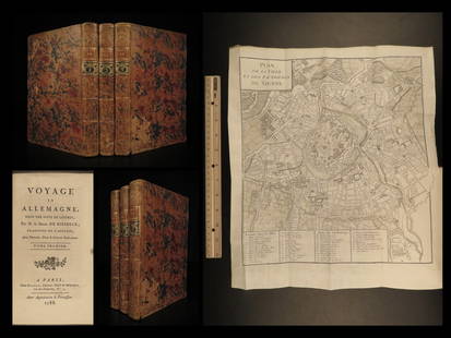
Sold20221788 Voyages Germany MAP Johann Riesbeck Letters Munich Vienna Austria 3v SET1788 Voyages Germany MAP Johann Riesbeck Letters Munich Vienna Austria 3v SET Johann Kaspar Riesbeck was a 18th-century German travel writer best-known for his book Letters from a French traveler in GSee Sold Price
Sold2024Exceptional 18th Century Map of The Carolinas, Maryland and VirginiaBy Johann Baptist Homann, Germany, late 17th/early 18th century. Hand colored map of the region which is excellent and quite rare. The map giving excellent details of the region and having exquisite eSee Sold Price
Sold2021Lot of 12 Early 19th Century MapsMostly by Jeffery's. Depicting the East Indies, Germany and surround, Asia, Africa, "Turky in Asia" , Italy and surround, Spain & Portugal, early North America, France, South America, Europe, and HungSee Sold Price
Sold2023ANTIQUE 18TH C HAND COLORED MAP OF OTTOMAN EMPIREAn antique early 18th-century hand-colored engraved map representing the Ottoman Empire. Published in Nuremberg, Germany, 1720. Titled Imperium Turcicum, technical information in Latin in the lower leSee Sold Price
Sold20231748 1ed History of Germany Frankish Carolingian Holy Roman Empire MAPS Barre 5v1748 1ed History of Germany Frankish Carolingian Holy Roman Empire MAPS Barre 5v Joseph Barre was an 18th-century French theologian who today is much better known for his book History of Germany. ThisSee Sold Price
Sold2023Antique Map Print - Europe - Map of Silesia - Poland - Czech Republic - WroclawDescription: Map of Silesia. Silesia is a historical region of Central Europe that lies mostly within Poland, with small parts in the Czech Republic and Germany. Date: 17th Century Material: Paper DimSee Sold Price
Sold2023Map of TransylvaniaMap of Transylvania probably 18th century. Historical map of Transylvania, old-coloured engraving, inscribed, behind glass. Signs of age. 53 x 63 cm.See Sold Price
Sold202318th C Antique Historical Map Of Montreal Quebec1758 Antique Historical Hand Tinted Map Of Montreal, Titled Plan of the Town and Fortifications of Montreal or Ville Marie in Canada. Map measures 7 inches H x 10 W within matting, framed 14.5 inchesSee Sold Price
Sold20191794 Sea Chart of South Part Sumatra 18th Century Mapa very rare 18th century antique sea chart. This is an uncolored copper plate engraving. Image measures 24\" x 32.5\". This map has been matted and is ready for framing. A stunning chart of the southeSee Sold Price
Sold202018th Century Map of Caribbean: faded, in 2 parts, 11 x18th Century Map of Caribbean: faded, in 2 parts, 11 x 14-1/2 inchesSee Sold Price
Sold2022Map, Andalusia Castellum Gibraltar, Matthai (Matthias)Map, Andalusia Castellum Gibraltar, Matthai (Matthias) Seutteri, showing Gibraltar, South of Spain & several insets Minorca, Gibraltar, early part of the 18th Century, map is 19.25" by 22.25" (sight),See Sold Price
Sold2022C35 loose MAPS OF ESSEX (18th. & 19th. Century)C35 loose MAPS OF ESSEX (18th. & 19th. Century) C35 loose MAPS OF ESSEX (18th. & 19th. Century), including: Harrison: View accurate & correct map of Essex, 1787 (Folio, hand coloured) with a tear & smSee Sold Price
Sold2023Antique 18th C Map of the Gulf of Mexico, M. Rizzi ZannoniM. RizziZannoniMapofthe Gulfof Mexico, Caribbean, and parts of Central America, hand-colored engraving on paper, titled "Carte Geo-Hydrographique du Golfe de Mexico Et Des Ses Isles". Published in ParSee Sold Price
Sold2018ANTONIO ZATTA (ITALIAN, 18TH CENTURY) MAP / ATLAS OFANTONIO ZATTA (ITALIAN, 18TH CENTURY) MAP / ATLAS OF NORTH AMERICA, SET OF 12, hand-colored, on laid paper, comprising title page lettered in part "LE / COLONIE UNITE / DELL' / AMERICA SETTENTR'LE." aSee Sold Price
Sold201718th Century Map of the Carolinas by Thomas Conder1788, London. The map features the Carolinas and part of Georgia including Savannah and Augusta. The piece is in good overall condition with some scattered wrinkles and fold lines consistent with ageSee Sold Price
May 16DuMouchellesJohann Kaendler (German, 18th C.) for Meissen (German) Porcelain Figural Grouping, Allegory of$300(1 bid)
4 days LeftLunds Auctioneers & Appraisers Ltd.Late 18th C. German Painted Chest, "Maria Weberin 1798", 30 1/2" x 65 3/4" x 24 1/2".CA$200
May 18Rich Penn AuctionsDecorative Art, map of South America, late 18th C., framed & matted, Exc cond, 24"H x 20"W overall.$50


![Willem Blaeu - "Palatinus ad Rhenum": 18th/19th century map of Germany titled, "Palatinus ad Rhenum". Inscribed in the plate, "Guiljelmum Blaeu". [Image: 16" x 19 1/2" on larger sheet; Frame: 21 1/2" x 25 1/4"]. Toning, severe water stain](https://p1.liveauctioneers.com/1221/84347/43548899_1_x.jpg?height=310&quality=70&version=1453846766)