Sold2023Baines, Edward 1817 Antique Map. USA & Canada, War of 1812"United States of America Exhibiting the Seat of War on the Canadian Frontier" Copper Engraved Map Published 1817, London for "History of the Wars of the French Revolution..." by Edward Baines. FoldsSee Sold Price
Sold2023Baines, Edward 1817 Antique Map. Egypt and Part of SyriaWood Engraved Map (Reverse side blank) Engraved Map Published 1817, London for "History of the Wars of the French Revolution..." by Edward Baines. Paper Size: 10 x 8 inch (25 x 20cm) Very minor toningSee Sold Price
Sold2023Baines, Edward 1817 Antique Map. Battle of the Nile, EgyptWood Engraved Map (Reverse side blank) Published 1817, London for "History of the Wars of the French Revolution..." by Edward Baines. Paper Size: 10 x 8 inch (25 x 20cm) Very minor toning. Good ConditSee Sold Price
Sold2023Baines, Edward 1817 Antique Map. Italy with the Alpine FrontierCopper Engraved Map Published 1817, London for "History of the Wars of the French Revolution..." by Edward Baines. Paper Size: 10 x 8 inch (25 x 20cm) Very minor toning. Good ConditionSee Sold Price
Sold2023Baines, Edward 1817 Antique Map. Egypt and Part of SyriaWood Engraved Map (Reverse side blank) Published 1817, London for "History of the Wars of the French Revolution..." by Edward Baines. Paper Size: 10 x 8 inch (25 x 20cm) Very minor toning. Good ConditSee Sold Price
Sold2023Baines, Edward 1817 Antique Map. Spain and PortugalWood Engraved Map (Reverse side blank) Published 1817, London for "History of the Wars of the French Revolution..." by Edward Baines. Folds as issued. Paper Size: 12 x 10 inch (30 x 25cm) Very minor tSee Sold Price
Sold2023Baines, Edward 1817 Antique Map. Europe according to the Treaty of Vienna"Chart Illustrative of the Campaigns of the Wars of the French Revolution" Copper Engraved Map Published 1817, London for "History of the Wars of the French Revolution..." by Edward Baines. Folds as iSee Sold Price
Sold2023Baines, Edward 1817 Antique Map. Germany"Map of Germany as designed by the treaty of Paris concluded May 30th 1814" Copper Engraved Map Published 1817, London for "History of the Wars of the French Revolution..." by Edward Baines. Folds asSee Sold Price
Sold2023Baines, Edward 1817 Antique Map. Spain and PortugalWood Engraved Map (Reverse side blank) Published 1817, London for "History of the Wars of the French Revolution..." by Edward Baines. Folds as issued. Paper Size: 12.5 x 10 inch (32 x 25cm) Very minorSee Sold Price
Sold2023Baines, Edward 1817 Antique Map. French EmpireCopper Engraved Map Published 1817, London for "History of the Wars of the French Revolution..." by Edward Baines. Folds as issued. Paper Size: 12.5 x 10 inch (32 x 25cm) Some toning, otherwise fineSee Sold Price
Sold2023Baines, Edward 1817 Antique Naval Map. Battle of TrafalgarWood Engraved Map (Reverse side blank) Published 1817, London for "History of the Wars of the French Revolution..." by Edward Baines. Paper Size: 10 x 8 inch (25 x 20cm) Very minor toning. Good ConditSee Sold Price
Sold2023BAINES, EDWARD. HISTORY OF THE WARS. 2 VOLS. 1817Baines, Edward. HISTORY OF THE WARS OF THE FRENCH REVOLUTION FROM THE BREAKING OUT OF THE WAR IN 1792, TO THE RESTORATION OF A GENERAL PEACE IN 1815; comprehending the civil history of Great Britain aSee Sold Price
Sold2019Wells, Edward 1817 Antique Map of EuropeCopper Engraved Map Published 1817, London for "A Companion to the Holy Bible; The Sunject, Sacred Geography..." by Edward Wells. Paper Size: 10.5 x 8 inch (27 x 21cm) Good ConditionSee Sold Price
Sold2019Wells, Edward 1817 Antique Map of AsiaCopper Engraved Map Published 1817, London for "A Companion to the Holy Bible; The Sunject, Sacred Geography..." by Edward Wells. Paper Size: 10.5 x 8 inch (27 x 21cm) Good ConditionSee Sold Price
Sold2019Wells, Edward 1817 Antique Map of AfricaCopper Engraved Map Published 1817, London for "A Companion to the Holy Bible; The Sunject, Sacred Geography..." by Edward Wells. Paper Size: 10.5 x 8 inch (27 x 21cm) Good ConditionSee Sold Price
Sold2023Barclay, James 1808 Antique Map. North America - USA Canada"North American from the best Authorities" by Scarce issue Engraved by Lawson, Halifax. Copper Engraved Map Published 1806, London for "Barclay's Complete and Universal English Dictionary" by the Rev.See Sold Price
Sold2023Russell & Barclay C1825 Antique Map. North America. USA CanadaCopper Engraved Map Published C1825., by Fisher & Son, "A Complete Atlas of the World" by John Russell et al. The companion Atlas to "A Complete and Universal English Dictionary" by James Barclay. PapSee Sold Price
Sold2023Vyse, Charles 1805 Antique Map. North America USA CanadaCopper Engraved Map Published 1805 (Map dated 1799) London for "Geography for Youth. A New Grammar: Containing A Comprehensive System of Modern Geography…" by Charles Vyse. Folds as issued, Paper SiSee Sold Price
Sold2023Walker, John C1805 Antique Map. North America USA CanadaCopper Engraved Map Published C1805, London for "The Universal Gazetteer: Being a Concise Description" [Walker's Geography] by John Walker. Folds as issued. Paper Size: 10 x 8 inch (25 x 20cm) Good CoSee Sold Price
Sold2018Barlow 1807 Antique Map of North America. USA CanadaCopper Engraved Map Published 1807 by Brightly & Kinnersley, Bungay, England for "A General View of the World, Geographical, Historical and Philosophical" by The Rev. E. Blomfield. Maps Engraved by BaSee Sold Price
Sold2018Thomson: Antique Map of Canada & Nova Scotia, 1817Title/Content of Map: Canada and Nova Scotia. Date Printed: 1817 Cartographer: THOMSON, JOHN & CO. Size (inches): 16.1x22 No.43 (unnumbered) from Thomson's New General Atlas 1817. W. Dassauville engr.See Sold Price
Sold2024Russell & Allen (Pub) 1812 Map. North America. USA CanadaFolio Copper Engraved Map Published 1812 by Russell and Allen, Manchester for "A New And Commercial System Of Geography" Paper Size: 15.5 x 9 inch (39 x 23cm) Minor toning, otherwise Good ConditionSee Sold Price
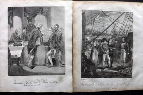
Sold2023Baines, Edward 1817 Pair of Military & Naval Prints"Execution of the Peace of Paris in 1814" and "Surrender of Napoleon to Capt. Maitland£ Copper Plate & Wood Engraving (Reverse side blank) Published 1817, London for "History of the Wars of the FrencSee Sold Price
Sold2023Baines, Edward 1817 Lot of 6 Military/Naval etc PortraitsCopper Plate Published 1817, London for "History of the Wars of the French Revolution..." by Edward Baines. Paper Size: 10 x 8 inch (25 x 20cm) Some toning presentSee Sold Price
May 17Albion AuctionsBlackie (Pub) 1882 Folio Map. Canada - Quebec, Nova Scotia, New Brunswick, Prince Edward$5
May 18Blackstone Valley Auctions & Estates LLCRevolutionary Era War Map of the Attack on Ft. Moultrie.$120(2 bids)
3 days LeftHunt and Peck Estate Services, Inc.Rare 1896 Antique Herbarium and Plant Descriptions Edward T. Nelson$50(1 bid)


![Walker, John C1805 Antique Map. North America USA Canada: Copper Engraved Map Published C1805, London for "The Universal Gazetteer: Being a Concise Description" [Walker's Geography] by John Walker. Folds as issued. Paper Size: 10 x 8 inch (25 x 20cm) Good Co](https://p1.liveauctioneers.com/3952/311930/166897810_1_x.jpg?height=310&quality=70&version=1701713718)


![History of the American War of 1812 [1817] (1 of 8)](https://p1.liveauctioneers.com/5755/327684/176532836_1_x.jpg?height=282&quality=70&version=1714078974)


![[Daguerreotype] Revolutionary War & War of 1812 Hero (1 of 4)](https://p1.liveauctioneers.com/7226/322253/173251484_1_x.jpg?height=282&quality=70&version=1710004847)