Sold2023De Eylanden van Pehou' by VAN KEULEN. Penghu Islands Taiwan. VOC chart 1753 mapTitle: De Eylanden van Pehou' by VAN KEULEN. Penghu Islands Taiwan. VOC chart 1753 map Description: De Eylanden van Pehou' by Johannes van Keulen (1753). Early 18th century Dutch sea chart with old coSee Sold Price
Sold2022Faroe Islands.- North Atlantic.- Keulen (Gerard van) Nieuwe afteekening van de Eylanden van Fero,Faroe Islands.- North Atlantic.- Keulen (Gerard van) Nieuwe afteekening van de Eylanden van Fero, scarce sea chart of the Faroe Islands with north oriented to the right, rhumb lines, compass roses, soSee Sold Price
Sold2021Johannes van Keulen (Dutch, 1654-1715)Johannes van Keulen (Dutch, 1654-1715) , "Pas kaart van de Noord Kust van Espaniola met d Eylanden daar Benoorden", Amsterdam, 1684, hand-colored engraved sea-chart, with inset maps of Tortuga and PorSee Sold Price
Sold2019MAP - East Indies - Indonesia. TirionEast Indies - Indonesia. Isaac Tirion, Kaart van de Papoasche Eilanden, 1753 (dated). Hand Color. This beautifully engraved chart spans from the Spice Islands (Sallawatty, Patenta, Gammen, Land van WaSee Sold Price
Sold2018van Keulen: Antique Map Guadeloupe & Marie Galante 1720Title/Content of Map: Nieuwe Land en Zee Kaart van de Eylanden Guadalupe en Mariegalande Cartographer: van Keulen Place & Date: Amsterdam / 1720/1780 Size: 22 1/2" x 19 7/8" Condition: b&w; overall agSee Sold Price
Sold2022KEULEN, JOHANNES VAN Pas kaart van West Indien behelsende soo deszelffs vasie kusten als d' OnderKEULEN, JOHANNES VAN Pas kaart van West Indien behelsende soo deszelffs vasie kusten als d' Onder behoorende Eylanden aan de Noord Oçeaan. Amsterdam: Johannes van Keulen, [1735]. Engraved map, haSee Sold Price
2017van Keulen: Antique Sea Chart of South Hispaniola, 1682Map: Pas-kaart Van de Zuyd-Kust van Espanjola Cartographer: van Keulen Place & Date: Amsterdam / 1682 Size: 23" x 20" Condition: outline color (wash in cartouche); top margin trimmed close; light overSee Sold Price
Sold20221687 Keulen Map of North and South America's Mostly Atlantic Coastal Areas -- Pas Kaart van WestTitle: 1687 Keulen Map of North and South America's Mostly Atlantic Coastal Areas -- Pas Kaart van West Indien Behelsende soo Deszelffs Vaste Kusten als d'Onder Behoorende Eylanden aan de Noord OceaanSee Sold Price
Sold20201684 Pas kaart Van de Caribes Tusschen I. Barbados en IThis is an authentic antique map of the Lesser Antilles by Johannes Van Keulen. The map was published in Amsterdam in the year 1684. This is an impressive hand colored example of Van Keulen’s nSee Sold Price
Sold2023Van Keulen map of the Chesapeake Bay AreaVAN KEULEN, Johannes (1654-1715). Pas Kaart van de Zee Kuysten van Virginia. Engraved map with original hand color in part. Amsterdam, circa 1695. 20 3/4” x 24” sheet, 25” x 28 1/2&rSee Sold Price
Sold2024MAP, Africa, SansonWestern Africa, Cape Verde Islands. Nicolas Sanson, D'Eilanden van Capo Verde, de Kust en't Landt der Negeren..., from Algemeene Weereld-Beschryving…, 1705 (published). Hand Color. This is an attracSee Sold Price
Sold2019Gerard Van Keulen (1654-1715, Amsterdam), "Pas KaartGerard Van Keulen (1654-1715, Amsterdam), "Pas Kaart Von West Indien," 1690, hand colored engraved map, H. - 21 in., W. - 25 in.See Sold Price
Sold2015Insulae lavae Pars Occidentalis... (and) Insulae lavaeJohannes van Keulen (1645-1715) & Adriaan Reelant (1676-1718). 2 double page engraved maps with original hand-color in full. Amsterdam: G. van Keulen, 1728. 20 3/4 x 24 inches, 28 1/2 x 31 1/2 inchesSee Sold Price
Sold2022Colom's Map of the Western Indian Ocean, c. 1658COLOM, Arnold (1624-1668). Oost Indien van Cabo de Bona Esperanca tot Ceilon. Engraved map with original hand color in outline. Amsterdam, c. 1658. 22 1/4" x 25 1/2" sheet. Colom's Zee Atlas is amongSee Sold Price
Sold2022Sammlung von über 50 Kupferstichen aus dem "Recueil d'Estampes d'après les plus céSammlung von über 50 Kupferstichen aus dem "Recueil d'Estampes d'après les plus célèbres Tableaux de la Galerie Royale de Dresde". Um 1753. Je Kupferstich auf festem Vergé. BlSee Sold Price
Sold2022Jean Louis Ernest Meissonier(French, 1815-1891) Les Deux Van de Velde, the brothers Van de Velde, Willem (1633-1707) and his brother Adriaen (1636-1672), signed lower left conjoined "EMeissonier 1856", oil on panel, 10-5-8 x 8-3See Sold Price
Sold2022(NETHERLANDS.) Heyman van Dyck. Voorne Caart-boeck van alle de Dorpen, en Polders Gelegen Inden(NETHERLANDS.) Heyman van Dyck. Voorne Caart-boeck van alle de Dorpen, en Polders Gelegen Inden Lande van Oost, ende West Voorne. Elaborate double-page etched and engraved allegorical title by RomeynSee Sold Price
Sold2022(HAWAII.) Group of 7 eighteenth and nineteenth century engraved maps.(HAWAII.) Group of 7 eighteenth and nineteenth century engraved maps. Vp, vd - La Perouse, after. Chart of the Parts of the Sandwich Islands. / Chart of the Sandwich Islands. 20¾x16¾ inchesSee Sold Price
Sold2022GHEYN (JACOB DE) Wapenhandelinghe van Roers Musquetten ende Spiessen, The Hague, [1607]GHEYN (JACOB DE) Wapenhandelinghe van Roers Musquetten ende Spiessen, text in Dutch, engraved decorative title (the title caption and dedication text pasted within the engraved borders), 117 engravedSee Sold Price
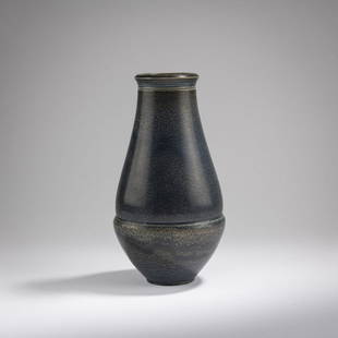
Sold2023Henry van de Velde, Vase, 1902Henry van de Velde, Vase, 1902, H. 25.5 cm. Made by Reinhold Hanke, Höhr. Stoneware, dark blue high firing glaze. Marked: Artist's signet (embossed), Hanke (incised)., Föhl/Neumann, Henry vaSee Sold Price
Sold2023Netherlandish School: The Madonna Nurturing the Infant Christoil and tempera on wood panel; accompanied by a letter of authentication from Willem L. van de Watering of Wouter Janssen Gallery, dated 20 November, 1996, attributing the present work to the Master oSee Sold Price
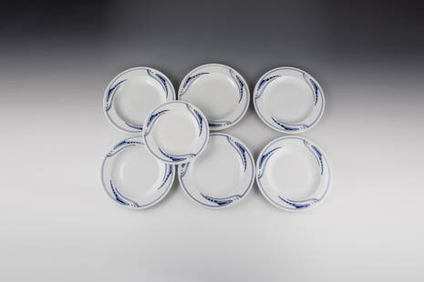
Sold2021Sieben Teller ''Peitschenhieb''Sieben Teller ''Peitschenhieb'' Henry van de Velde (Entwurf) 1903, Meissen (Ausführung) vor 1924 Bestehend aus sechs flachen Tellern und einem tiefen Teller. Fahne mit flach reliefiertem OrnamentdeSee Sold Price
Sold202370304: A Marshall Islands Navigation Map Micronesia, 1A Marshall Islands Navigation Map Micronesia, 19th century Constructed of coconut palm leaf midribs and shells. Such maps or charts were for navigating specific atolls and islands in MicrSee Sold Price
Sold2017De Wit Portolan Sea Chart of EuropeTotius Europae Victoria... Frederic De Wit (1630-1706). Engraved map with original hand color. Amsterdam, 1675. 20 x 35 1/2 inches sheet, 27 1/2 x 43 inches framed. “The most striking and decorativeSee Sold Price
23 hrs LeftTrillium Antique Prints & Rare BooksDe Jode, Rare, pub. 1593 - Map of Kingdom of Napoli, Italy (Neapolitani Regni exacta ac diligens$130(3 bids)
Jun 07Freeman's | Hindman[MAP]. SARTINE, Antoine Plan de la Barre et du Havre de Charles-Town...1778. RARE REVOLUTIONARY WAR$1,000(1 bid)
23 hrs LeftTrillium Antique Prints & Rare BooksPrevost - Map of China, Korea, Japan, Phlippines and Surrounding Islands$50
May 28Carlo Bonte AuctionsTheophile Marie Francoise Lybaert (1848-1927), 'Gent, Rijkste Diamant in de kroon van Vlaanderen',€1,500
121 Lots AwayNi-Cola Classics - Automobilia Auction & Classic Car SalesAutomobilia 22-parts cigarette picture albumsSee Sold Price
23 hrs LeftTrillium Antique Prints & Rare BooksPrevost - Pair of Engravings of Chinese Boats or Junks$50
23 hrs LeftTrillium Antique Prints & Rare BooksPrevost - Pair of Engravings of Indian Coast and Ocean$50
5 days LeftJasper52Carte du Golphe de Bengale'. Bay of Bengal. India Burma Ceylon. BELLIN 1746 map$85
23 hrs LeftTrillium Antique Prints & Rare BooksDe Jode, Rare, pub. 1593 - Map of the Holy Land (Descriptio Et Situs Terrae Sanctae Alio Nomine$100(1 bid)
5 days LeftJasper52Les Indes Orientales… South Asia India Indochina. SANTINI / VAUGONDY 1784 map$85
6 days LeftPotter & Potter AuctionsSEGUR, General, Count Philip de (1780-1873). History of the...$80(1 bid)


![KEULEN, JOHANNES VAN Pas kaart van West Indien behelsende soo deszelffs vasie kusten als d' Onder: KEULEN, JOHANNES VAN Pas kaart van West Indien behelsende soo deszelffs vasie kusten als d' Onder behoorende Eylanden aan de Noord Oçeaan. Amsterdam: Johannes van Keulen, [1735]. Engraved map, ha](https://p1.liveauctioneers.com/292/250642/130213616_1_x.jpg?height=310&quality=70&version=1654271664)


![GHEYN (JACOB DE) Wapenhandelinghe van Roers Musquetten ende Spiessen, The Hague, [1607]: GHEYN (JACOB DE) Wapenhandelinghe van Roers Musquetten ende Spiessen, text in Dutch, engraved decorative title (the title caption and dedication text pasted within the engraved borders), 117 engraved](https://p1.liveauctioneers.com/1043/250376/130017602_1_x.jpg?height=310&quality=70&version=1654076918)


![[MAP]. SARTINE, Antoine Plan de la Barre et du Havre de Charles-Town...1778. RARE REVOLUTIONARY WAR (1 of 1)](https://p1.liveauctioneers.com/197/329395/177650540_1_x.jpg?height=282&quality=70&version=1715364962)


