Sold2019Gerhart Mercator (1512-1598), "Persici vel SophorumGerhart Mercator (1512-1598), "Persici vel Sophorum Regni Typus," 1607, hand colored, H.- 19 in., W.- 22 1/4 in.See Sold Price
Sold2018Ortelius Antique Map: Persici Sive Sophorum Regni TypusTitle/Content of Map: Persici Sive Sophorum Regni Typus Date Printed: 1609 Cartographer: Abraham Ortelius Material/Medium: No color. Spanish text on verso. From the first modern atlas- the Theatrum OrSee Sold Price
Sold2019Ortelius: Persici Sive Sophorum Regni TypusNo Reserve! Title/Content of Map: Persici Sive Sophorum Regni Typus Date: 1606 Cartographer: Abraham Ortelius Material/Medium: Hand color. English text on verso. From the first modern atlas- the TheatSee Sold Price
Sold2017European School (16th century), Map of "PersiaEuropean School (16th century), Map of "Persia (Sophorum Regnum), Armenia, Assyria, Mesopotamia et Babylonia," hand-colored copper engraving, overall (with frame): 14.25"h x 16.5"w. Property from theSee Sold Price
Sold2016Regni Sinae vel Sinae Propriae by Homann Heirs 1745Map Title: Regni Sinae vel Sinae Propriae Artist: Homann Heirs Publisher: Homann Heirs, Nuremberg Date: 1745 Size: 22.5 x 20.2 inches Medium: Hand colored copper plate engraving A very detailed map ofSee Sold Price
Sold2019Russia & North Pacific.- Ortelius (Abraham) TartariaeRussia & North Pacific.- Ortelius (Abraham) Tartariae sive Magni Chami Regni Typus, the earliest printed map to focus on the North Pacific, showing the Kingdom of the Great Khan in Asia, including RusSee Sold Price
Sold20231650 Jansson Map of the Persian Empire -- Persia, sive Sophorum RegnumTitle: 1650 Jansson Map of the Persian Empire -- Persia, sive Sophorum Regnum Cartographer: J Jansson Year / Place: 1650, Amsterdam Map Dimension (in.): 14.9 X 19.4 in. This is a rather handsome map oSee Sold Price
Sold2022Abraham Ortelius and Jacob Van Meurs, Two Vintage MapsABRAHAM ORTELIUS and JACOBUS VAN MEURS (Belgian, 1527-1598), (Dutch, 1760-1824), Tartariae Sive Magni Chami Regni typus, circa 1609 AND Novissima et Accuratissima Totius Americae Descriptio per JacobuSee Sold Price
Sold2020BLAEU, WILLEM. Persia Sive Sophorum Regnum.BLAEU, WILLEM. Persia Sive Sophorum Regnum. Hand-colored double-page engraved map of modern-day Afghanistan, Pakistan, Iraq, Iran, and the Persian Gulf region. 15½x21 inches sheet size, top and bSee Sold Price
Sold20241738 Homann Heirs / Hase Map of ChinaRegni Sinae Vel Sinae Propriae Mappa et Descriptio GeographicaSee Sold Price
Sold2021Map, Abraham Ortelius "Valentiae Regni olim ContestanorMap, Abraham Ortelius "Valentiae Regni olim Contestanorum Si Ptolemaeo, Edentanorum Si Plinio Credimus Typus", Calencia, Spain, map is 13.75" by 19.25".See Sold Price
Sold2017Launay World Map - Typus Orbis Terrarum, 1720Map: Launay World Map - Typus Orbis Terrarum Cartographer: C. Launay Date: ca. 1720 Size: 5 x 8 inches A quite rare, unique and charming double hemisphere map showing very rough approximations for theSee Sold Price
Sold2018Ortelius Antique Map: Regni Neapolitani VerissimaTitle/Content of Map: Regni Neapolitani Verissima Secundum Antiquorum Date Printed: 1579 Cartographer: Abraham Ortelius Material/Medium: No color. Latin text on verso. From the first modern atlas- theSee Sold Price
Sold2021Map, ""Typus Orbis Terrarum", by Abraham OrteliusMap, ""Typus Orbis Terrarum", by Abraham Ortelius, plate size is 14" by 19.5", edition, age unknown, good conditionSee Sold Price
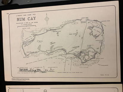
Sold2021Boating maps, rum cay, conception island, San Salvador.Maps from 1981 tropic Isle publishers, Inc By Harry Kline, Rum Cay, Conception island, San Salvador. Size 11“ x 17“See Sold Price
Sold2018Homann: Antique Map of Sicily Kingdom/Islands, 1747Title/Content of Map: Regni & insulae Siciliae'. Sicily kingdom/islands. Isole Eolie. The Contado (Contea) di Modica, or county of Modica is shown in red. The Aeolian Islands are marked at the top ofSee Sold Price
Sold2018Weigel: Antique Map of Sardinia, 1720Title/Content of Map: Regni Sardiniae Descriptio Cartographer: Weigel Place & Date: Nuremberg / 1720s Size: 12 1/2" x 15 3/4" Condition: wash color; very light overall age toning A beautifully designeSee Sold Price
Sold2018Sicily.- Ortelius (Abraham) Siciliae Veteris Typus, mapSicily.- Ortelius (Abraham) Siciliae Veteris Typus, map of ancient Sicily, with an inset plan of Syracuse, with three decorative cartouches, ships and sea monsters, engraving, on laid paper with crossSee Sold Price
Sold2022ABRAHAM ORTELIUS LEODIENSIS DIOECESIS TYPUS MAPABRAHAM ORTELIUS LEODIENSIS DIOECESIS TYPUS MAP: Leodiensis Dioecesis Typus. Antwerp, c. 1612. Engraved regional map of Belgium with hand-coloring, from Theatrum Orbis Terrarum. Framed and matted. AppSee Sold Price
Sold2020Map- ''Bohemia. Regni Bohemiae descriptioMap- ''Bohemia. Regni Bohemiae descriptio''- engraving with hand-coloring and two cartouches, from an atlas by Abraham Ortelius, ca. 1590, with Latin descriptions. 13 x 20''See Sold Price
Sold2018South East Asia.- Ortelius (Abraham) Indiae OrientalisSouth East Asia.- Ortelius (Abraham) Indiae Orientalis Insularumque Adiacientium Typus, map of southern Asia from India across to Java and New Guinea, and including China and Japan to the north, withSee Sold Price
Sold2022Belgium.- Ortelius (Abraham) Leodiensis DioecesisBelgium.- Ortelius (Abraham) Leodiensis Dioecesis Typus, map showing the Muese River valley including Namur and Liege, with west oriented at top of map, engraving with full hand-colouring, platemark 3See Sold Price
Sold2021Antique Hand Colored MapHand colored map "Exactisima Regni Scotiae". {Image: 22" H x 19" W; Frame: 29" H x 24" W]. Tears.See Sold Price
Featured3 days LeftJasper521702 Homann Map of Northern Italy, Milan Included -- Belli Typus in Italia…$160
2 days LeftFreeman's | Hindman[Maps & Atlases] Braun, Georg, and Frans Hogenberg: Londinum, Feracissimi Angliae...$1,000
4 days LeftJasper52Bahamas. San Salvador Crooked Rum Cay Mariguana ADMIRALTY chart 1892 (1919) map$140
14 hrs LeftSchilb Antiquarian Rare Books1848 Emory Military Reconnaissance 1ed California MAP Indians Texas New Mexico$82(8 bids)
14 hrs LeftSchilb Antiquarian Rare Books1977 JRR Tolkien 1st ed Silmarillion Lord of the Rings Middle Earth + MAP$155(7 bids)
8 hrs LeftLeonard Auction, a division of The Leonard CompanyEuropean and United States Map Assortment$150(1 bid)
14 hrs LeftSchilb Antiquarian Rare Books1890 Livingstone 1ed In Darkest Africa Henry Stanley Emin Pasha Expedition MAP$145(8 bids)
14 hrs LeftSchilb Antiquarian Rare Books1870 BEAUTIFUL Life of Jesus Christ Fleetwood Bible ART Miracles Jerusalem Map$150(7 bids)
Featured3 days LeftJasper521720 Homann Map of the Caspian Sea Region -- Provinciarum Persicarum Kilaniae nempe Chirvaniae$220
Jul 06Case Antiques, Inc. Auctions & AppraisalsColton's Atlas of the World, 1856, in Two Volumes; plus Africa / Mahdist War Map$500(1 bid)
2 days LeftFreeman's | Hindman[Maps & Atlases] Seutter, Matth(ias).: Novus Orbis sive America...$300(1 bid)
14 hrs LeftSchilb Antiquarian Rare Books1790 Life of Jesus Christ Fleetwood Bible ART Miracles Jerusalem MAP Holy Land$120(7 bids)


![Antique Hand Colored Map: Hand colored map "Exactisima Regni Scotiae". {Image: 22" H x 19" W; Frame: 29" H x 24" W]. Tears.](https://p1.liveauctioneers.com/1221/202668/104343465_1_x.jpg?height=310&quality=70&version=1622581573)


![[Maps & Atlases] Braun, Georg, and Frans Hogenberg: Londinum, Feracissimi Angliae... (1 of 3)](https://p1.liveauctioneers.com/65/332523/179335170_1_x.jpg?height=282&quality=70&version=1717622830)


![[Maps & Atlases] Speed, John: Spaine (1 of 2)](https://p1.liveauctioneers.com/65/332523/179335175_1_x.jpg?height=282&quality=70&version=1717709446)
![[Maps & Atlases] Speed, John: The Turkish Empire (1 of 2)](https://p1.liveauctioneers.com/65/332523/179335176_1_x.jpg?height=282&quality=70&version=1717709446)


![[Maps & Atlases] Seutter, Matth(ias).: Novus Orbis sive America... (1 of 2)](https://p1.liveauctioneers.com/65/332523/179335174_1_x.jpg?height=282&quality=70&version=1717709447)


