Sold2024A New and Correct Sea-Chart of the Western and Southern Ocean, 18thCEdmund Halley, London, 18th century. Lower right: This CHART is Sold by J. Mount, T. Page, and W. Mount, on Tower-hill. With splits and losses. Overall size appx. 24" x 29".See Sold Price
Sold20231740 New Map or Chart Western Atlantic OceanFolding map being "A New Map or Chart of the Western or Atlantic Ocean with part of Europe Africa and America" Shewing the Course of the Galleons, Flota and C to the West Indies" piublished in 1740 anSee Sold Price
Sold20231740 New Map or Chart Western Atlantic OceanFolding map being "A New Map or Chart of the Western or Atlantic Ocean with part of Europe Africa and America" Shewing the Course of the Galleons, Flota and C to the West Indies" published in 1740 andSee Sold Price
Sold2019John Senex (1678-1740), "A New and Correct Chart of theJohn Senex (1678-1740), "A New and Correct Chart of the Atlantic Ocean Reduced Describing parts of the Coasts of Europe, Africa and America," 1721, H. -21 in., W. - 25 3/8 in.See Sold Price
Sold2022Thomas Bowen,1778, Map, Western Atlantic Ocean"Thomas Bowen, London 1778, A New & Accurate Chart of the Western or Atlantic Ocean Drawn from Surveys and most approved Maps & Charts" by Thomas Bowen. Hand colored, modern framing. Dimensions:SightSee Sold Price
Sold2019Emanuel Bowen (1693-1767, "A New and Accurate Chart ofEmanuel Bowen (1693-1767, "A New and Accurate Chart of the Western Atlantic Ocean," 1778, H.- 9 in., W.- 14 1/2 in.See Sold Price
Sold20181740 Large Folding Chart Western AtlanticA New Map of Chart of the Western or Atlantic Ocean with part of Europe Africa and America: Shewing the Course of the Galleons, Flota, and C to and from the West Indies, London, printed for E. Cave atSee Sold Price
Sold2019Emanuel Bowen (1694-1767), "A New and Accurate ChartEmanuel Bowen (1694-1767), "A New and Accurate Chart of the Western or Atlantic Ocean," 1788, matted and mounted, hand colored, H. - 10 in., W. - 12 1/2 in.See Sold Price
Sold2018Western or Atlantic Ocean Color Map 1740A New Map or Chart of the Western or Atlantic Ocean, with part of Europe, Africa & America. 1740. Printed for E. Cave, London. 15" x 12". We ship all items in this auction in-house with the most fairSee Sold Price
Sold2019Four Maps from Nicholas Tindal's (1687-1774),Four Maps from Nicholas Tindal's (1687-1774), Continuation Of Rapin's History," A Correct Chart of St. George's Channel and the Irish Sea," "A Correct Chart of the German Ocean," "A Correct Chart of tSee Sold Price
Sold2024Pacific Ocean North west sheet. Micronesia. ADMIRALTY sea chart 1875 (1954) mapTITLE/CONTENT OF MAP: 'Pacific Ocean (in four sheets) - North west sheet' DATE PRINTED: Surveyed 1875. Published 1875. New edition 1933. Corrections to 1954 IMAGE SIZE: Approx 70.5 x 103.5cm, 27.75 xSee Sold Price
Sold2022Dudley Sea Chart of Western FranceDUDLEY, Sir Robert (1574-1649). [France] Carta particolare della costa di Guasconnia in Francia che comincia con il Fiuime di Burdeaux e Finisce con l'Isola di Heys. Engraved map. Florence, 1646. 20 7See Sold Price
Sold2017(3) 19TH C. ASIAN / MELANESIAN SEA CHARTSIncluding: "Indian Ocean", London, Published by James Imray and Son, 1877. Blue paper backed engraving on wove paper, Japanese cloth edging, showing from east coast of Africa to Australia, 41" x 75",See Sold Price
Sold2017Moll - Correct Map of the Whole World, 1719Herman Moll (1654?-1732), cartographer and publisher A New & Correct Map of the Whole World Shewing y.e Situation of its Principal Parts. Viz the Oceans, Kingdoms, Rivers, Capes, Ports, Mountains, WooSee Sold Price
Sold2022[MANUSCRIPT MAP-FLORIDA & MISSISSIPPI RIVER] Map Showing Raiford's Proposed Artificial River and[MANUSCRIPT MAP-FLORIDA & MISSISSIPPI RIVER] Map Showing Raiford's Proposed Artificial River and Plan to Continue the Western and Southern Inland System of Navigation to Harbors in the Atlantic. [FernSee Sold Price
Sold2022Charles Drew Cahoon New England Sand Dune PaintingCharles Drew Cahoon Massachusetts,1861-1951 Impressionist depiction of a windswept sand dune framing a distant ocean. Cahoon's father was a sea captain and amateur artist, from a young age Cahoon woulSee Sold Price
Sold2020Good Early Southern HighboyGood early highboy. Primary wood looks like walnut. Yellow pine secondary wood. Probably South western Pennsylvania. H 72", W lower case: 40"; W upper case 38-1/2, overall D 22-1/4". Provenance. SuzieSee Sold Price
Sold2021Aquatic-Themed Etched Glass Panel from the First ClassAquatic-Themed Etched Glass Panel from the First Class Ballroom of the Ocean Liner S.S. United States Designed by Charles Gilbert, early 1950s In colorless glass, decorated with underwater sea creaturSee Sold Price
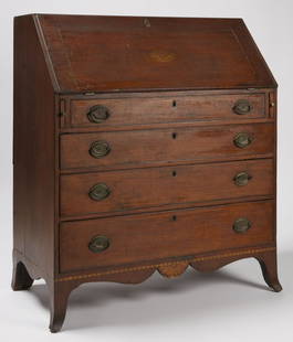
Sold2020Southern Federal Eagle Inlaid DeskSouthern Federal Eagle inlaid & carved slant lid desk, wild cherrywood with hard pine secondary , probably western Maryland, ca. 1795-1802. The dovetailed case presents a molded and inlaid hinged slanSee Sold Price
Sold2017De Wit Portolan Sea Chart of EuropeTotius Europae Victoria... Frederic De Wit (1630-1706). Engraved map with original hand color. Amsterdam, 1675. 20 x 35 1/2 inches sheet, 27 1/2 x 43 inches framed. “The most striking and decorativeSee Sold Price
Sold2021Late 16th C. North Italian Steel Field Armor SuitWestern/Southern Europe, northern Italy, perhaps Brescia or Milan, and Germany, ca. 1580s CE. A suit of steel-plate armor used for field duties. The close helmet features a roped vertical crest, a visSee Sold Price
Sold2024Chicago Coin Tournament Ski-Bowl-Full Restoration*NO SHIPPING! - PICKUP OR THIRD PARTY TRANSPORT ONLY* 1957 Totally restored, cosmetically and mechanically! Brand new, correct back glass, new plexiglass shield and 3 sets of keys (coin box, and 2 mecSee Sold Price
Sold2017FRAMED WORLD MAP BY HERMAN MOLL, 1719'A New & Correct Map of the Whole World, by Herman Moll, Geographer, 1719.' Hand tinted and framed. Frame size: 73 x 124 cm (28 3/4 x 48 3/4 in.)See Sold Price
Sold2021North PacificTitle: North Pacific Publication Date: 1868 Cartographer: IMRAY, JAMES F. Publisher: JAMES IMRAY & SON Description: Comprehensive large sea chart of Japanese and Alaskan waters with copious soundingsSee Sold Price
Jun 23Schilb Antiquarian Rare Books1848 Emory Military Reconnaissance 1ed California MAP Indians Texas New Mexico$2(2 bids)
Jun 30JM Hobby Supply and Railroad Artifact AuctionsTwo Micro-Trains HOn3 Narrow Gauge Cars-Colorado and Southern/Denver Boulder and Western$20
Jun 06Freeman's | HindmanHEMINGWAY, Ernest. The Old Man and the Sea. FIRST EDITION, FIRST PRINTING. In a FIRST ISSUE DUST$500
Jun 29JM Hobby Supply and Railroad Artifact AuctionsKanawha and Michigan RY Dressel Switch Lamp$100(1 bid)
Jun 07Freeman's | HindmanCOUSTEAU, Jacques-Yves. A group of 15 works by and about Cousteau. WITH ONE SIGNED WORK.$100
Jun 29JM Hobby Supply and Railroad Artifact AuctionsChicago Milwaukee St Paul and Pacific RR Adlake Non-Sweating Switch Lamp$100(1 bid)


![Dudley Sea Chart of Western France: DUDLEY, Sir Robert (1574-1649). [France] Carta particolare della costa di Guasconnia in Francia che comincia con il Fiuime di Burdeaux e Finisce con l'Isola di Heys. Engraved map. Florence, 1646. 20 7](https://p1.liveauctioneers.com/1968/250616/130196506_1_x.jpg?height=310&quality=70&version=1654190895)


![[MANUSCRIPT MAP-FLORIDA & MISSISSIPPI RIVER] Map Showing Raiford's Proposed Artificial River and: [MANUSCRIPT MAP-FLORIDA & MISSISSIPPI RIVER] Map Showing Raiford's Proposed Artificial River and Plan to Continue the Western and Southern Inland System of Navigation to Harbors in the Atlantic. [Fern](https://p1.liveauctioneers.com/292/250642/130213644_1_x.jpg?height=310&quality=70&version=1654271664)