Sold20231740 New Map or Chart Western Atlantic OceanFolding map being "A New Map or Chart of the Western or Atlantic Ocean with part of Europe Africa and America" Shewing the Course of the Galleons, Flota and C to the West Indies" piublished in 1740 anSee Sold Price
Sold20231740 New Map or Chart Western Atlantic OceanFolding map being "A New Map or Chart of the Western or Atlantic Ocean with part of Europe Africa and America" Shewing the Course of the Galleons, Flota and C to the West Indies" published in 1740 andSee Sold Price
Sold20181740 Large Folding Chart Western AtlanticA New Map of Chart of the Western or Atlantic Ocean with part of Europe Africa and America: Shewing the Course of the Galleons, Flota, and C to and from the West Indies, London, printed for E. Cave atSee Sold Price
Sold2018Western or Atlantic Ocean Color Map 1740A New Map or Chart of the Western or Atlantic Ocean, with part of Europe, Africa & America. 1740. Printed for E. Cave, London. 15" x 12". We ship all items in this auction in-house with the most fairSee Sold Price
Sold2022Thomas Bowen,1778, Map, Western Atlantic Ocean"Thomas Bowen, London 1778, A New & Accurate Chart of the Western or Atlantic Ocean Drawn from Surveys and most approved Maps & Charts" by Thomas Bowen. Hand colored, modern framing. Dimensions:SightSee Sold Price
Sold2023Martin, Benjamin 1772 Antique Map. Atlantic Ocean with Europe Africa America"A New Geographical Map or Chart of the Atlantic Ocean with the Continents of Europe, Africa & America &c on the East & West Side of it" Copper Engraved Map Published 1772, London for "The Young GentlSee Sold Price
Sold2019Emanuel Bowen (1693-1767, "A New and Accurate Chart ofEmanuel Bowen (1693-1767, "A New and Accurate Chart of the Western Atlantic Ocean," 1778, H.- 9 in., W.- 14 1/2 in.See Sold Price
Sold2023Martin, Benjamin 1772 Antique Map. Atlantic Ocean with Europe Africa America"A New Geographical Map or Chart of the Atlantic Ocean with the Continents of Europe, Africa & America &c on the East & West Side of it" Copper Engraved Map Published 1772, London for "The Young GentlSee Sold Price
Sold2019Emanuel Bowen (1694-1767), "A New and Accurate ChartEmanuel Bowen (1694-1767), "A New and Accurate Chart of the Western or Atlantic Ocean," 1788, matted and mounted, hand colored, H. - 10 in., W. - 12 1/2 in.See Sold Price
Sold2019John Senex (1678-1740), "A New and Correct Chart of theJohn Senex (1678-1740), "A New and Correct Chart of the Atlantic Ocean Reduced Describing parts of the Coasts of Europe, Africa and America," 1721, H. -21 in., W. - 25 3/8 in.See Sold Price
Sold2024Map of the Vast Atlantic Ocean (London, 1755)Map of the Vast Atlantic Ocean (London, 1755) "A new chart of the vast Atlantic Ocean: exhibiting the seat of war, both in Europe and America, likewise the trade winds & course of sailing from one conSee Sold Price
Sold2024Historical Nautical Chart of Atlantic Ocean Map c.1650This attractive map of the Atlantic Ocean (Mar del Nort) is extended to include much of North America, Europe, and western Africa; though interior details are relatively scarce, especially in the WestSee Sold Price
Sold2019Two Maps from Thompson's General Atlas: Chart of NorthTwo Maps from Thompson's General Atlas: Chart of North Atlantic Ocean with tracks, 1815; together with a Chart of the North and Baltic Seas, 1816, Atlantic- H.- 20 in., W. - 25 in.; Baltic- H. - 19 inSee Sold Price
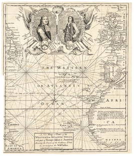
Sold20171740 Ornate Copperplate Engraved Portrait MapHistoric Maps 1740 Ornate Copperplate Engraved Map with Portraits of British Admirals “Robert Blake” & “Edward Vernon, Esq.” 1740-Dated, Copperplate Engraved Map titled “A New Map or Chart oSee Sold Price
Sold2019John Senex (1678-1740), "A New Map of the EnglishJohn Senex (1678-1740), "A New Map of the English Empire in the Ocean of America or West Indies, A New Map of the Island of Jamaica," c. 1798, hand colored, H.- 22 in., W.- 26 1/4 in.See Sold Price
Sold2017Map of Atlantic Ocean Communication, 1885Map: Atlantic Ocean &c. Shewing the Communication Between Europe, North America and the Pacific From Black's General Atlas of the World New and Revised Edition. Edinburgh 1885 Size: 17.25 x 12.25 inchSee Sold Price
Sold2017Antique Nautical Ship's Map of Atlantic Ocean, 1882Map: Track Chart Norddentsher Lloyd, Bremen Date Printed: 1882 Cartographer: Anonymous Size: 15 x 7 Condition: Good Several vertical folds as issued. Somewhat browned. Right side partially glued to caSee Sold Price
Sold2019Carte de lOcean Occidental. North Atlantic Ocean FerroTITLE/CONTENT OF MAP: 'Carte de lOcean Occidental dressée pour servir à l'Histoire Generale des Voyages [Map of the Western Ocean]' DATE PRINTED: 1746 IMAGE SIZE: Approx 33.0 x 47.0cm, 13 x 18.5 incSee Sold Price
Sold2022Vintage Nautical Map: Karte von dem Abendlændischen OceanVintage Nautical Map: Karte von dem Abendlændischen Ocean. size: 13 x 18 matte, 18 x 22 outside frame. Google: Nautical chart of North Atlantic Ocean with portions of North and South America, SouthSee Sold Price
Sold2020THOMSON, JOHN. Atlantic or Western Ocean.THOMSON, JOHN. Atlantic or Western Ocean. Double-page engraved chart of the northern Atlantic Ocean showing a pronounced outline of the Gulf Stream. 20½x25½ inches sheet size, ample margins;See Sold Price
Sold2021BLUEBACK CHART OF THE NORTH ATLANTIC OCEAN PublishedBLUEBACK CHART OF THE NORTH ATLANTIC OCEANPublished 1844Published by E. & G.W. Blunt, New York. Marked with numerous navigational notations in pen and pencil.Approx. 38" x 48.5".See Sold Price
Sold2017Bellin: Map of the Southern Ocean, 1746Map: Carte de l'Ocean Meridional Cartographer: Bellin Place & Date: Paris / 1746/1760 Size: 18" x 12 1/2" Bellin's chart of the southern Atlantic Ocean, from Prevost d'Exiles' influential collection oSee Sold Price
Sold2021Norton Atlantic Ocean depth chart. 1856 by K. Johnston,Title: Norton Atlantic Ocean depth chart. 1856 by K. Johnston, Edinburg & London Date/Period: 1856 Materials: Lithographic printing Size: 22 x 13”. Paper Sheet / 10 x 7 1/2”. Map size 1856See Sold Price
4 days LeftJasper52Bahamas. San Salvador Crooked Rum Cay Mariguana ADMIRALTY chart 1892 (1919) map$140
May 14Fleischer's Auctions1755 Map Partie de l'Amerique Septentrionale, qui comprend Le Cours de L'Ohio...$200(3 bids)
5 days LeftHunt and Peck Estate Services, Inc.Jacques Nicolas Bellin Map Of Western Part Of New France Or Canada$200(1 bid)
Featured4 days LeftJasper52HISPANIOLA. Ocean current directions 1889. Cuba Puerto Rico. USCGS 1889 map$20
5 hrs LeftActivity AuctionsAuthentic Coal & Wood Relic Piece From Titanic Wreckage on 6x8 Photo (The Zone COA)$100
1 day LeftChurchill GalleriesCHART: South Pacific Ocean / SOCIETY ISLANDS - WESTERN GROUP/ HUAHINE TO MAUPITI With the$10
May 18MusicGoldmine.comGotye ft. Kimbra "Somebody That I Used To Know" RIAA 6X Multi-Platinum Digital Single Award - New$250
4 days LeftJasper52West India Islands & Caribbean Sea Sheet 2 ADMIRALTY sea chart 1913 (1949) map$120
4 days LeftJasper52Jamaica & the Pedro Bank. South Cuba Haiti. ADMIRALTY sea chart 1866 (1968) map$120
4 days LeftJasper52Venezuela Coast Trinidad Tobago Isla Margarita ADMIRALTY chart 1894 (1950) map$120
7 days LeftTrillium Antique Prints & Rare BooksPrevost - Map of the South Pacific Ocean with New Holland (Australia), New Zealand, and part of the$50


![Carte de lOcean Occidental. North Atlantic Ocean Ferro: TITLE/CONTENT OF MAP: 'Carte de lOcean Occidental dressée pour servir à l'Histoire Generale des Voyages [Map of the Western Ocean]' DATE PRINTED: 1746 IMAGE SIZE: Approx 33.0 x 47.0cm, 13 x 18.5 inc](https://p1.liveauctioneers.com/5584/144578/73088403_1_x.jpg?height=310&quality=70&version=1561513819)


