Sold20231855 Collins Map of the Danube from Iron Gates to the Delta -- Collins' Chart of the River DanubeTitle: 1855 Collins Map of the Danube from Iron Gates to the Delta -- Collins' Chart of the River Danube Shewing the Seat of War Cartographer: H G Collins Year / Place: 1855 c., London Map Dimension (See Sold Price
Sold2022Matthaeus Seutter Decorative MapLater issue of an original Matthaeus Seutter (1678-1757), Augsburg, 1740 map of Transylvania, Moldavia, Wallachia and Bulgaria, outlining Eastern Europe, River Danube and the Black Sea. [Sight: 19 3/4See Sold Price
Sold20181690 Coronelli Map of Cyprus -- Acamantis InsulaTitle/Content of Map: 1690 Coronelli Map of Cyprus -- Acamantis Insula hoggidi Cipro, Posseduta dalla Republica Veneta sin'all'Anno 1571 Date: 1690 c., Venice Cartographer: V Coronelli Size: 18.1 X 24See Sold Price
2021Danube River, Balkans, Greece 1762 by Homann HeirsTitle: Danube River, Balkans, Greece 1762 by Homann Heirs Date/Period: 1762 Materials: Copperplate engraved Size: 24 x 20 1/2" Shows the course of the Danube as the great river crosses regions of theSee Sold Price
Sold2024P. Cosmografo Coronelli Map Of Constantinople CanalTop Left Map made according to the reports of Luigi Ferdinando Marsili, Large portion map made according to the reports of Monsier GallandSee Sold Price
Sold2021Danube River course north Balkans and Hungary 1762 byTitle: Danube River course north Balkans and Hungary 1762 by Homann Heirs Date/Period: 1762 Materials: Copperplate engraved Size: 24 x 20 1/2" The areas covered are Hungary, Slovenia, Bosnia, Croatia,See Sold Price
Sold20241691 Coronelli Map of Northwest Germany and Netherlands -- La Vestfalia, detta Altrimenti / DieTitle: 1691 Coronelli Map of Northwest Germany and Netherlands -- La Vestfalia, detta Altrimenti / Die Westpalen Cartographer: V Coronelli Year / Place: 1691, Venice Map Dimension (in.): 17.8 X 23.8 iSee Sold Price
Sold2019Modern Danube River ConsoleModern Danube River Console, Walnut. Size: 36'' x 55.25'' x 16.25'' (91 x 140 x 41 cm).See Sold Price
Sold2021Western Danube River course. Northern Italy,Title: Western Danube River course. Northern Italy, Switzerland, Austria, Slovenia and Croatia. 1762. Homann Heirs Date/Period: 1762 Materials: Copperplate engraved Size: 24 x 20 1/2" The western portSee Sold Price
Sold2021JORIS HOEFNAGEL Danube River EngravingJORIS HOEFNAGEL Danube River Engraving, inscriptions to piece in Dutch and Latin, subject views of rivers and river banks, measures 23 1/2 x 27 3/8 inches, wooden frame, surface wear to frame, professSee Sold Price
Sold2022Vincenzo Coronelli Map Fortezza Vecchia ItalyItalian map Fortezza Vecchia / Fortezza Nova, Livorno, Italy. Vincenzo Coronelli, cartographer. 10 1/4" x 17"See Sold Price
Sold2020Early 20th Century Impressionist Danube River LandscapeOil on wood 6 1/2 x 3 1/2 in.See Sold Price
Sold2019Lyttleton, George 1810 HC Map. River Scheldt, Belgium"Sketch of the River Scheldt, from Flushing to Antwerp, with the Soundings Fortifications &c 1810" Hand Coloured Copper Engraved Map Published 1810, London for "The History of England..." by George CoSee Sold Price
Sold2022Cellarius & Patrick 1816 Map. Danube, Balkans"Pannonia Moesia, Illyricum & Thracia" Copper Engraved Map Published 1816, London for "Geographia Antiqua" by Samuel Patrick. Maps based on those by Andreas Cellarius. Folds as issued. Paper Size: 10See Sold Price
Sold2017Rand McNally: Antique World Map, Rivers & MountainsMap: Rand McNally World Map and Comperative Chart of Rivers and Mountains -- The World on Mercator's Projection [verso] Western Hemisphere Cartographer: Rand McNally Year / Place: 1898, Chicago Map DiSee Sold Price
Sold2021Mudie, Robert 1841 Map. Rivers & MountainsSteel Engraved Map/Chart Published 1841, London for "Gilbert's Modern Atlas of the Earth" by Robert Mudie. Drawn and Engraved by Russell and Archer. Scarce. Paper Size: 13 x 10.5 inch (33 x 27cm) EdgeSee Sold Price
Sold2021Rare Late Bronze Age Hallstatt Bronze Short SwordAncient Central Europe, Danube River Basin, Hallstatt culture, Late Bronze Age, ca. 1400 to 1100 BCE. A rare and finely preserved sword forged from bronze with ribbed handle beneath a discoidal pommelSee Sold Price
Sold2018Ancient Hallstatt Bronze Spiral Hair Ring**Originally Listed At $450** Central Europe, Danube River Basin, Hallstatt culture, ca. 1000 to 700 BCE. A gorgeous bronze hair ring with a double spiral design formed from a single elongated strip.See Sold Price
Sold2018Central European Bronze Age Coiled BraceletCentral Europe (Germany, Austria), Danube River Basin, ca. 8th to 6th century BCE. A wonderful bronze bracelet with a loosely-coiled form. Made by bending a long, rounded bronze strip, the tight spiraSee Sold Price
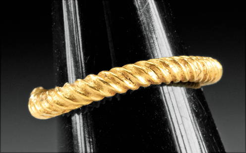
Sold2022Ancient Hallstatt Gold Ring - Penannular / Twisted FormAncient Central Europe, Germany and Austria, Danube River Basin, Late Bronze Age, Hallstatt culture, ca. 1200 to 800 BCE. A stunning gold ring of penannular form. The ancient ring is comprised of a tuSee Sold Price
Sold2018Greek Thracian Bronze Neck TorcNorthern Greece / Danube River Valley, Thrace, Iron Age, ca. 7th century BCE. An elegant torc (also torq) made from a thick bronze wire with its surface incised to give it the appearance of twisted meSee Sold Price
Sold2021Fine Thracian Leaded Bronze Twisted Neck Torq**Originally Listed At $400** Northern Greece / Danube River Valley, Thrace, Iron Age, ca. 7th century BCE. An elegant torq (also torc) shaped from a thick leaded bronze wire that twists several timesSee Sold Price
Sold2022Choice Hallstatt Bronze Socketed Spear TipAncient Central Europe, Danube River Basin, Hallstatt culture, Late Bronze Age, ca. 1400 to 1100 BCE. A well-preserved example of a cast-bronze spear tip featuring a petaloid blade head, a thick midriSee Sold Price
Sold2018Ancient Hallstatt Bronze Spiral Hair RingCentral Europe, Danube River Basin, Hallstatt culture, ca. 1000 to 700 BCE. A gorgeous bronze hair ring with a double spiral design formed from a single elongated strip. Each spiral is comprised of niSee Sold Price
Jul 02Tiberius AuctionsMasterly relief of the Baptism of Christ in the Jordan, Danube region, 16th/17th century€1,000
5 days LeftSwann Auction Galleries(TRAVEL.) [Zadok Cramer.] The Navigator; Containing Directions for Navigating the Monongahela,$450
3 days LeftJasper521653 Blaeau Map of the Dnieper River -- Lectori S. Hunc Borysthenis Tractum ut ad Nostrum$850
5 days LeftSwann Auction Galleries(CIVIL WAR--VIRGINIA.) Robert B. Hathaway. Letter with detailed map of the possible river crossings$600
Jun 30Brandywine Valley AuctionsRare Antique 17th Century William Beery English Map of Bavaria$25(1 bid)
3 days LeftJasper521874 Holmes Plan of New York's Upper East Side -- Map of the Common Lands from 76th to 93rd Street$750
4 days LeftA.H. Wilkens Auctions & AppraisalsJEFFERYS. AN EXACT CHART OF THE RIVER ST. LAURENCECA$200(1 bid)
Featured3 days LeftJasper521645 Jansson Map of Portugal and Parts of Spain -- Portugallia et Algarbia quae olim Lusitania$200
Featured3 days LeftJasper52VERY RARE Map of Washington D.C & Georgetown Land Reclamation, From a Supreme Court Exhibit$320
3 days LeftJasper521640 Blaeu/Pijnacker Map of Northern Netherlands -- Drentia Comitatus. Transiselaniae Tabula II$240
Featured3 days LeftJasper52VERY RARE. Map of Washington D.C. Plan for Reclamation of the Marshes, From a Supreme Court Exhibit,$320
Featured3 days LeftJasper521795 Lewis Map of Maryland -- The State of Maryland, from the best Authorities$360


![Rand McNally: Antique World Map, Rivers & Mountains: Map: Rand McNally World Map and Comperative Chart of Rivers and Mountains -- The World on Mercator's Projection [verso] Western Hemisphere Cartographer: Rand McNally Year / Place: 1898, Chicago Map Di](https://p1.liveauctioneers.com/5584/108569/55677982_1_x.jpg?height=310&quality=70&version=1504123318)


![(TRAVEL.) [Zadok Cramer.] The Navigator; Containing Directions for Navigating the Monongahela, (1 of 1)](https://p1.liveauctioneers.com/199/334052/180498043_1_x.jpg?height=282&quality=70&version=1718909401)


![[MAPS - LOUISIANA]. Map of Louisiana from D'Anville's Atlas. London, 1788. (1 of 0)](https://p1.liveauctioneers.com/dist/images/placeholder.jpg?height=282&quality=70)