Sold2015A. M. Perrot. Map of Chinese Empire. 1837.Print of hand colored steel engraving titled Empire Chinois“.Author A. M. Perrot.Engraved by unknown.From Dictionnaire universel Geographie moderne, description physique, politique et historique deSee Sold Price
Sold2015BRITISH EMPIRE / INDIA STERLING SILVER CIGARETTE CASEBRITISH EMPIRE / INDIA STERLING SILVER CIGARETTE CASE, front with a map of India set with seven untested ruby-like stones, reverse featuring the Taj Mahal set with five stones. Retains most of originaSee Sold Price
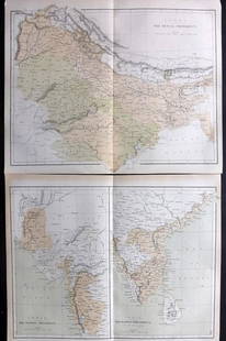
Sold2021Nolan, Edward C1880 Pair of Maps of India"India. The Bombay Presidency/India. The Madras Presidency" and "India The Bengal Presidency" Steel Engraved Map Published C1880, London for "The Illustrated History of the British Empire in India andSee Sold Price
Sold2021Nolan, Edward C1880 Decorative Map of IndiaSteel Engraved Map Published C1880, London for "The Illustrated History of the British Empire in India and the East" by Edward H. Nolan. Centre fold as issued. Paper Size: 12 x 10 inch (30 x 25cm) GooSee Sold Price
Sold2023Nolan & Hughes C1880 Antique Map. Eastern HemisphereLithograph Map Published C1880, London for "The Illustrated History of the British Empire in India and the East" by Edward H. Nolan. Centre fold as issued. Drawn by W. Hughes. Paper Size: 12 x 10 inchSee Sold Price
Sold2021Nolan, Edward C1880 Map of The East India IslandsSteel Engraved Map Published C1880, London for "The Illustrated History of the British Empire in India and the East" by Edward H. Nolan. Centre fold as issued. Paper Size: 12 x 10 inch (30 x 25cm) GooSee Sold Price
Sold2019Nolan, Edward C1880 Map of The Eastern HemisphereSteel Engraved Map Published C1880, London for "The Illustrated History of the British Empire in India and the East" by Edward H. Nolan. Centre fold as published. Paper Size: 12.5 x 9.5 inch (32 x 24cSee Sold Price
Sold2021Nolan, Edward C1880 Map of Eastern HemisphereSteel Engraved Map Published C1880, London for "The Illustrated History of the British Empire in India and the East" by Edward H. Nolan. Centre fold as issued. Paper Size: 12 x 10 inch (30 x 25cm) SmaSee Sold Price
Sold2019Japan C1880 Pair of Maps by Nolan & Blackie"The Islands of Japan with Corea..." Steel Engraved Map Published C1880, London for "The Illustrated History of the British Empire in India and the East" by Edward H. Nolan. Centre fold as published.See Sold Price
Sold2021Nolan, Edward C1880 Lot of 3 Maps. China, Japan, AsiaSteel Engraved Map Published C1880, London for "The Illustrated History of the British Empire in India and the East" by Edward H. Nolan. Centre fold as issued. Paper Size: 12 x 10 inch (30 x 25cm) GooSee Sold Price
Sold2016V. Levasseur: Map of Asia, 1850Map: Asie Maker: V. Levasseur Date: 1850 Origin Paris Date: 11 x 16.5 inches A highly decorative nineteenth century map of Asia, dominated by Russian, Chinese Empires and British India and French IndoSee Sold Price
Sold2023Maps 19th Cent. Mixed Lot of 20Incl India, UK, France, China, Iran, Sweden/Norway, Denmark, British Empire, Venice, Austria, Russia and Switzerland. Examples by Findlay/Kelly, Reclus, Baedeker, Blackie, Fullarton, William MackenzieSee Sold Price
Sold2022Tallis, John (Pub) C1860 Map of British India"British India" Steel Engraved Map Published C1860, London for "The Indian Empire: Its History, Topography, Government" by Robert Montogmery Martin. Centre fold as issued. Paper Size: 13.5 x 10.5 inchSee Sold Price
Sold2023Map of Asia toward the end of the 18th century – PerthesFascinating hand-colored map depicts Asia at the end of the 18th century. The British had established themselves in India and the Chinese Empire was under Manchu control. Also depicts Southeast Asia iSee Sold Price
Sold2021Atlas - Bartholomew, J. G. 1904 British Empire, Maps"The Handy Atlas of the British Empire" by John Bartholomew. London: Ward, Lock & Co., nd but 1904. 12mo (150 x 100mm) Complete with 120 numbered maps, double sided. The actual number of maps is muchSee Sold Price
Sold2022Times Atlas 1895 Mixed Lot of 9 MapsIncl Religions, Wind, Japan, Palestine, Antilles, Central America/West Indies, Atlantic, South America and British Empire. Lithograph Map Published 1895, London for "The Times Atlas" Paper Size: Up toSee Sold Price
Sold20231762 Accurate Map British Empire North AmericaAn Accurate Map of the British Empire in North America as Settled by the Preliminarues in 1762, by Gibson for Gentleman's Magazine, 1762. Folding map with inset of the entance to the Mississippi. FineSee Sold Price
Sold2017Colton: Hindostan (British India) MapHindostan (or British India), 14 x 17 in, 1857, J. H. Colton Please note that this lot has a confidential reserve. When you leave a bid in advance of the auction, submit your maximum. Jasper52 will biSee Sold Price
Sold2021Tallis, John (Pub) 1852 Map. British IndiaSteel Engraved Map with Original Outline Hand Color Published 1852-56 by John Tallis, London for "The Universal Pronouncing Dictionary" by Thomas Wright. Drawn & Engraved by John Rapkin. Centre fold aSee Sold Price
Sold2023Tallis, John (Pub) 1854 Antique Map. British IndiaSteel Engraved Map Published 1853-4 by John Tallis, London for "The Life and Times of the Late Duke of Wellington" by Thomas Gaspey. Drawn and Engraved by J. Rapkin. Folds as issued. Paper Size: 13.75See Sold Price
Sold2021(British Empire) INDIA'S SCIENTIFIC FRONTIER Hanna 1895Title: (British Empire) INDIA'S SCIENTIFIC FRONTIER Hanna 1895 Great Game Borders Afghanistan Date/Period: 1895 Materials: Hardcover Book Dimension: 7-1/2 x 5-1/8 x 5/8 Additional Information: Hanna,See Sold Price
Sold2021Rapkin, John 1858 Antique Map. British IndiaSteel Engraved Map Published 1858, London for "The History of the Indian Mutiny..." by Charles Ball. Centre fold as published. Drawn & Engraved by John Rapkin. Paper Size: 14 x 11 inch (36 x 28cm) GooSee Sold Price
Sold2022Universal Atlas 1893 LG Map. British EmpireLithograph Map Published 1893 by Cassell & Co., London for "The Universal Atlas" Centre fold as issued. Paper Size: 20 x 16 inch (51 x 40cm) Good ConditionSee Sold Price
Sold2022Times Atlas 1895 Antique Map. British EmpireLithograph Map Published 1895, London for "The Times Atlas" Centre fold as published. Paper Size: 21.5 x 16 inch (54 x 41cm) Good ConditionSee Sold Price
Jun 02Schilb Antiquarian Rare Books1897 History of British Empire England Scotland Canada James II MAPS India 6v$1
5 days LeftJasper52Isles Antilles Extrait des Cartes Angloises. British West Indies. BONNE 1780 map$70
5 days LeftJasper52St Christophers, Nevis & St Lucia. St Kitts. West Indies. THOMSON 1830 old map$120
Featured5 days LeftJasper52St Christophers, Nevis & St Lucia. St Kitts. West Indies. THOMSON 1817 old map$120
May 16Zikorn Arts & History ObjectsWest Indies Pt. Manzanilla to San Juan 1844 British Admiralty Map$100
5 days LeftJasper52West India Islands & Caribbean Sea Sheet 2 ADMIRALTY sea chart 1913 (1949) map$120
5 days LeftJasper52BRITISH WEST INDIES Jamaica Antigua Trinidad Dominica Bermuda Barbados 1876 map$20