Sold2016Map of Italy. Europe. 1854.Print of hand colored steel engraving titled „Carte pour servir a l’histoire del’Italie“.Drawn by L. Dussieux.Engraved by unknown.From „Atlas General De Geographie physique, politique et hisSee Sold Price
Sold2016Map of Italy. Europe. 1854.Print of hand colored steel engraving titled „Italia”.Drawn by L. Dussieux. Engraved by unknown.From „Atlas General De Geographie physique, politique et historique par L. Dussieux. Atlas de GeogSee Sold Price
Sold2024Johnson's Austria, Turkey in Europe and Greece. Balkans Venice 1866 old mapCAPTION PRINTED BELOW PICTURE: 'Johnson's Austria, Turkey in Europe and Greece // Candia' DATE PRINTED: 1866 IMAGE SIZE: Approx 45.0 x 63.5cm, 17.75 x 25 inches (Large); Please note that this is a folSee Sold Price
Sold2021Lot of 12 Early 19th Century MapsMostly by Jeffery's. Depicting the East Indies, Germany and surround, Asia, Africa, "Turky in Asia" , Italy and surround, Spain & Portugal, early North America, France, South America, Europe, and HungSee Sold Price
Sold20171862 Mitchell county map of Minnesota in near fineGreat chance to own an actual 150-year-old piece of history for a reasonable price. Beautiful and clean county map of Minnesota from Mitchell’s 1866 New General Atlas. When matted and framed, antiquSee Sold Price
Sold2019GERMANY general Map. Central Europe. Hungary.TITLE/CONTENT OF MAP: 'GERMANY, General map' The top image on the right hand side shows the entire map. To view a close up of the map showing the level of printed detail, please click on the bottom imSee Sold Price
Sold2016Map of Italy. Europe. 1835.Print of hand colored steel engraving titled „Italie“.Author C. V. Monin.Engraved by unknown.From the „Atlas Universel de Geography“ by C. V. Monin. Parsi. 1835.Italy officially the Italian ReSee Sold Price
Sold2022Antique Map Print - Italy - EuropeSet of 4 Map Prints. Antique lithographic map originates from "Letts's Popular Atlas", being a series of maps delineating the whole surface of the globe, with many special and original features; and aSee Sold Price
Sold2019SDUK: Pre-unification Italy, 1852The general map of Italy from the SDUK atlas, including Sicily, Malta, Sardinia, and Corsica, plus a list of the various pre-unification Italian states, their size, population (as of 1828), and populaSee Sold Price
Sold2024Antique Map - Europe - Italy With the Islands of Sicily, Corsica and SardiniaMap of iItaly with the islands of Sicily, Sardinia and Corsica by Francois Halma, 1700. Decorative large map of Italy, with an elaborate cartouche.See Sold Price
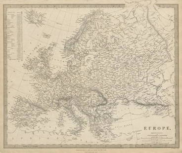
Sold2019EUROPE. General map. Inset table of population &TITLE/CONTENT OF MAP: 'EUROPE; inset table of population by country' The top image on the right hand side shows the entire map. To view a close up of the map showing the level of printed detail, pleasSee Sold Price
Sold2023EUROPE. General map. Inset table of population & density by country. SDUK 1844TITLE/CONTENT OF MAP: 'EUROPE; inset table of population by country' DATE PRINTED: This map was originally published by Baldwin & Cradock in 1836; this date is printed on the map. This edition of theSee Sold Price
Sold2024SOUTH AMERICA. general map. BARTHOLOMEW 1890 old antique plan chartTITLE/CONTENT OF MAP: 'South America' DATE PRINTED: 1890 IMAGE SIZE: Approx 42.0 x 30.5cm, 16.5 x 12 inches (Large); Please note that this is a folding map. TYPE: Antique colour map CONDITION: Good; sSee Sold Price
Sold2023SOUTH AMERICA. general map. BARTHOLOMEW 1890 old antique plan chartTitle: SOUTH AMERICA. general map. BARTHOLOMEW 1890 old antique plan chart Description: South America' by John Bartholomew (1890). Antique colour map, 42.0 x 30.5cm, 16.5 x 12 inches; Please note thatSee Sold Price
Sold2015Map of Ancient Italy. Europe. 1835.Print of hand colored steel engraving titled Italie Ancienne“.Author C. V. Monin.Engraved by unknown.From the Atlas Universel de Geography“ by C. V. Monin. Parsi. 1835.Italy officially the ItalianSee Sold Price
Sold2022Antique Map Print - Italy - Greece - Europe - SpainSet of 4 Map Prints. Hand-colored map print of the edition of 1851 from the work Universal Historical and Geographical Atlas ("Atlas Universel Historique et Geographique"). This iconic map contains diSee Sold Price
Sold2022Antique Map Print - Empire Italy - EuropeSet of 4 Map Prints. Hand-colored map print of the edition of 1851 from the work Universal Historical and Geographical Atlas ("Atlas Universel Historique et Geographique"). This iconic map contains diSee Sold Price
Sold2018Homann: Antique Map of Italy, 1720Title/Content of Map: Italia Cursoria'. Italy general map Date Printed: c1720 Image Size: Approx 52.0 x 63.0cm, 20.5 x 24.75 inches (Large); Please note that this is a folding map. Type: Large antiqueSee Sold Price
Sold2023Prémière partie de la carte d'Europe'. D'ANVILLE. Western Europe 1756 old mapTITLE/CONTENT OF MAP: 'Prémière partie de la carte d'Europe contenant La France, L'Alemagne, L'Italie, L'Espagne, & les Isles Britanniq.s. Publiée sous les auspices de Monseigneur LouisSee Sold Price
Sold2023Johnson's South America. Bolivia with Littoral. Patagonia 1866 old antique mapTitle: Johnson's South America. Bolivia with Littoral. Patagonia 1866 old antique map Description: Johnson's South America' by Alvin Jewett Johnson (1866). Large, decorative hand coloured 19th centurySee Sold Price
Sold2022Map of Europe - Italy - Corsica - Austria - Norway - Spain - Poland - John LodgeTitle: Map of Europe - Italy - Corsica - Austria - Norway - Spain - Poland - John Lodge Description: A fine 1778 map of Europe by the English map publisher John Lodge. Date/Period: 1778 Materials: PapSee Sold Price
Sold2022Antique Map of Europe - Italy - Milano - Rome - Tuscany - Umbria - BeckerAntique map of Italy by Becker, published in London, c 1843. This antique map was engraved by the omnigraph method by Francis Paul Becker & Company, Patentees circa 1842, with contemporary hand colourSee Sold Price
Sold2022Antique Map Print - Italy - Empire Greece - EuropeSet of 4 Map Prints. Hand-colored map print of the edition of 1851 from the work Universal Historical and Geographical Atlas ("Atlas Universel Historique et Geographique"). This iconic map contains diSee Sold Price
2018SDUK: Antique Map of Italy, 1845TITLE/CONTENT OF MAP: 'ITALY IV, General map including Sicily, Malta, Sardinia, and Corsica' DATE PRINTED: 1845 IMAGE SIZE: Approx 40.5 x 34.5cm, 16 x 13.5 inches (Large) TYPE: Antique steel engravedSee Sold Price
1 day LeftTrillium Antique Prints & Rare BooksPtolemy & Magini, pub. 1620 - Map of the Ancient World with Africa, Europe, Asia$50
Jun 04TimeLine Auctions Ltd.'The General Sir George Cockburn' Stone Age Classic British Teardrop-Shaped Knapped Flint Handaxe£5(1 bid)
6 days LeftHunt and Peck Estate Services, Inc.1867 United States General Land Office "Rapport af Chefen fur Land-Kontoret i Furenta Saterna."$200
May 11Fichter KunsthandelC. GÖTZLOFF (1799-1866), Gatehouse in Borghese Park, Rome, 1824, Etching€400
May 11Fichter KunsthandelG. CANELLA (1788-1847), Arena in Verona. Roman amphitheatre, around 1810, Pencil€1,000
May 11Fichter KunsthandelJ. KRAUSKOPF (*1787) attributed, Circus des Maxentius in Rom, around 1834, Watercolor€800
May 12Schilb Antiquarian Rare Books1869 ATLAS 42 MAPS America Africa Australia GERMANY Switzerland Sydow RARE$130(3 bids)
May 14Fleischer's AuctionsGen. Sherman's Inscribed "Grant and Sherman: Their Campaigns and Generals"$200(3 bids)
6 days LeftHunt and Peck Estate Services, Inc.Stefano Della Bella "Death Dragging an Old Man To His Tomb"$100