Sold2024SECOND WORLD WAR AFRICA. European colonies & German mandates 1940 old mapTITLE/CONTENT OF MAP: 'Africa: Political, Showing European Partition' DATE PRINTED: 1940 IMAGE SIZE: Approx 27.0 x 22.5cm, 10.5 x 9 inches (Medium) TYPE: Vintage colour map; Scale 1:35,000,000 CONDITISee Sold Price
Sold2023SECOND WORLD WAR AFRICA. European colonies & German mandates 1940 old mapTITLE/CONTENT OF MAP: 'Africa: Political, Showing European Partition' DATE PRINTED: 1940 IMAGE SIZE: Approx 27.0 x 22.5cm, 10.5 x 9 inches (Medium) TYPE: Vintage colour map; Scale 1:35,000,000 CONDITISee Sold Price
Sold2022SEVEN ENGRAVED MAPS.European, 18th-19th century. Printed with some hand coloring. Four on laid paper including three German and French military maps, "Plan des Camps de Pisek, 1741", 15.25"h. 20.25"w., battles of PeterwaSee Sold Price
Sold2024Pre-SECOND WORLD WAR AFRICA. European colonies & German mandates 1942 old mapTITLE/CONTENT OF MAP: 'Africa: European partition, pre-war' DATE PRINTED: 1942 IMAGE SIZE: Approx 27.5 x 22.5cm, 11 x 9 inches (Large) TYPE: Vintage colour map CONDITION: Good; suitable for framing. HSee Sold Price
SoldEASTERN EUROPEAN MAPS. Four framed maps.EASTERN EUROPEAN MAPS. Four framed maps. Comprising: Magni Ducatus Lithuaniae (18 1/4 x 22 1/2 in.); Emanuel Bowen's A New and Accurate Map of the Whole Russian Empire (15 x 20 in.); Polonia et SilesiSee Sold Price
Sold2023Portfolio of Vintage European MapsLarge artists portfolio with vintage maps of various European countries and cities, including: Germany, Rome, Vienna, Paris, Dresden, and others. Approximately 30 pieces. As is, as shown. Provenance:See Sold Price
Sold2023Two Folders of Vintage European MapsTwo folders of vintage European maps, including Spain, Portugal, Austrian Dominions, Prussia, Germany, etc. Provenance: Phyllis Lucas Gallery, NYC.See Sold Price
2016Large Vintage Fabric Printed Map of IndonesiaLarge Vintage Fabric Printed Map of Indonesia & the Indian Ocean. Mid 20th century. Measures 42 x 84 inches.See Sold Price
Sold2016Large Vintage Fabric Printed Map of IndonesiaLarge Vintage Fabric Printed Map of Indonesia & the Indian Ocean. Mid 20th century. Measures 42 x 84 inches.See Sold Price
Sold2018FOUR EUROPEAN MAPSComprising: a pair of the English Counties Devonshire and Dorsetshire, a large map of Africa and a Dutch “De L’ Academi des Royale Scienes” map of L’ Amerique. Largest (Africa) site meSee Sold Price
Sold201911 Vintage Michelin European Road Maps11 Vintage Michelin European Road Maps, used condition, wear, worn.See Sold Price
Sold2021Collection of 4 Vintage Maps, To Include H. MollCollection of four vintage maps, to include two reproduction H. Moll (1654-1732), North America, Mexico, Antarctica, etc 14"h x 12"d/ largest Provenance: A San Antonio, TX Collection We happily providSee Sold Price
Sold2023Four Framed European Mapsengravings on laid or wove paper, comprising: Robert Laurie and James Whittle, A New Map of the Kingdom of France Divided Into Its Governments..., London, circa 1794, sight 19-1/2 x 23-3/4 in.; SebastSee Sold Price
Sold2024GROUP OF PRINTS, MAPS AND SAMPLERS.American and European, 18th-19th century. Printed maps of Ohio, small booklet with wool on linen sampler examples, chromolithographs of insects, and several hand colored botanical prints published bySee Sold Price
Sold2020Vintage Lautrec Poster Tournee du Chat NoirPrinted by European Vintage Poster. Dimensions 27" x 19". This lot is located in Boca Raton, Fl and its shipment will be made directly by Artelisted. Shipping insurance is the responsibility of the buSee Sold Price
Sold2017Vintage Mobil, Pure, Standard, Shell & Gulf Road s(25) Vintage Road maps printed by American Standard, Mobilgas and Mobiloil, Shell, Texaco, Pure and Gulf from CA to Ontario and many states in-between. These road maps are in good used condition. AlsoSee Sold Price
Sold2022Erie, Pennsylvania Vintage Topography MapErie, Pennsylvania Vintage Topography Map Printed in 1923, based on a survey done in 1899 of Erie Pennsylvania. The map is in good condition with one small tear at the top of the map. Approximate sizeSee Sold Price
Sold2022Kentucky Lock Port Vintage Topography MapKentucky Lock Port Vintage Topography Map Printed in 1922, based on a survey done in 1906 of the Lockport Quadrangle in Kentucky. Map is in good condition with some tears around the edges. ApproximateSee Sold Price
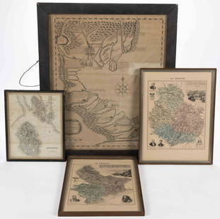
Sold2023ASSORTED EUROPEAN AND ASIAN MAPS, LOT OF FOURASSORTED EUROPEAN AND ASIAN MAPS, LOT OF FOUR, engraving on paper, three with hand-coloring, comprising a map of Buteshire in Scotland by William Home Lizars (Scottish, 1788-1859), two "LA FRANCESee Sold Price
Sold2017"The Serena Technique of Belly Dancing" - 4 CopiesThe four vintage editions printed 1972-1975. Largest: 8.75" H. Some yellowing to pages, the covers variously worn. Property from the estate of the renowned belly dancer Serena Wilson.See Sold Price
Sold2023Vintage Eastern European Nesting DollsVintage Eastern European nesting dolls, with four interior figures painted in traditional folk attire. [Largest: 6" H x 3" W]. In good condition.See Sold Price
Sold2023Vintage Eastern European Nesting DollsVintage Eastern European nesting dolls, with four interior figures painted in traditional folk attire. [Largest: 6" H x 3" W]. In good condition.See Sold Price
Sold2022Colorado Historic Maps [153133]Four different vintage travel maps of Colorado.A) Blazed Trails in Colorado, Compliments of Continental Oil Co., Denver, Colorado. Approx. 24 x 21 inches when unfolded. B) Classon's Colorado Green GuiSee Sold Price
May 30NY Elizabeth 1709 SEPTUAGINT GREEK BIBLE ILLUSTRATED WITH MAPS, VINTAGE VELLUM BOUND VERSION$50(1 bid)
2 days LeftRapid Estate Liquidators and Auction GalleryLot of 4 Vintage German Books Printed in Germany$45
3 days LeftThousand Planet Auction HouseCollection of European Earth-Toned Artisan Glass Beads, 20th Century$10
3 days LeftThousand Planet Auction HouseCollection of European Earth-Toned Artisan Glass Beads, 20th Century$10
24 hrs LeftJasper52Le Nord de l'Europe contenant le Danemark… Scandinavia Russia. BONNE 1780 map$35


![Vintage Eastern European Nesting Dolls: Vintage Eastern European nesting dolls, with four interior figures painted in traditional folk attire. [Largest: 6" H x 3" W]. In good condition.](https://p1.liveauctioneers.com/1221/275442/144661872_1_x.jpg?height=310&quality=70&version=1673880129)
![Vintage Eastern European Nesting Dolls: Vintage Eastern European nesting dolls, with four interior figures painted in traditional folk attire. [Largest: 6" H x 3" W]. In good condition.](https://p1.liveauctioneers.com/1221/284471/150138840_1_x.jpg?height=310&quality=70&version=1681226664)
![Colorado Historic Maps [153133]: Four different vintage travel maps of Colorado.A) Blazed Trails in Colorado, Compliments of Continental Oil Co., Denver, Colorado. Approx. 24 x 21 inches when unfolded. B) Classon's Colorado Green Gui](https://p1.liveauctioneers.com/2699/258185/134287643_1_x.jpg?height=310&quality=70&version=1660347389)


