Sold2018Thomson: Antique Map of Southern Germany, 1817Title/Content of Map: 'Germany, south of the Mayne'. This large, decorative map shows Southern Germany, including the Kingdom of Bavaria, Hesse-Darmstadt, the Grand Duchy of Baden, the Kingdom of WurtSee Sold Price
Sold2016Mitchell's New Universal Atlas 1847Heading: Author: Mitchell, S. Augustus Title: A New Universal Atlas Containing Maps of the Various Empires, Kingdoms, States and Republics of the World with a Special Map of each of the United StatesSee Sold Price
Sold2022MITCHELL'S UNIVERSAL ATLASNew Universal Atlas Containing Maps of the various Empires, Kingdoms, States, and Republics of the World, S. Augustus Mitchell, Philadelphia, 1847; Condition: boards detached; 17 1/4 x 14 inchesSee Sold Price
Sold2020Fremont's Narrative with Rufus Sage Map 1847Heading: Author: Frémont, John Charles Title: Narrative of the Exploring Expedition to the Rocky Mountains, in the year 1842; and to Oregon and North California, in the Years 1843-44 Place PublishedSee Sold Price
Sold2022Mitchell's large Mexican-American War map, 1847Heading: Author: Mitchell, Samuel Augustus Title: Map of Mexico, Including Yucatan & Upper California, Exhibiting the Chief Cities and Towns, the Principal Travelling Routes &c. Place Published: PhilSee Sold Price
Sold20171626 John Speede map Kingdom of Denmark1626 John Speede map of the Kingdom of Denmark- two sheet hand colored map w/ towns, costumes, & types vignettes border, double framed, 16" x 20 1/2"See Sold Price
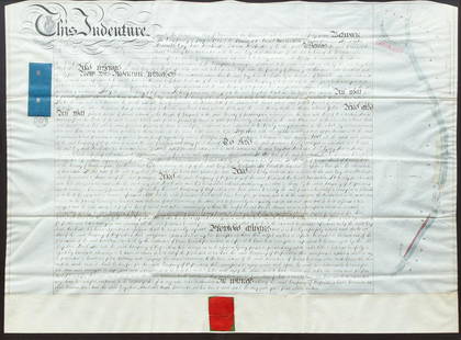
Sold2020British Greywell Indenture Map 1847British land indenture from 1847, ink on vellum, contract between Basingstoke Canal Navigation and the landowner, Baron Dorchester, to do work on the Greywell Canal, a road and tunnel which still exisSee Sold Price
Sold2023Lizars, Daniel 1831 LG Rare HC Map. Kingdom of Sardinia, ItalyLarge Folio Copper Engraved Map Published 1831-2 by John Hamilton, Successor to Daniel Lizars, Edinburgh for "The Edinburgh Geographical and Historical Atlas..." First Edition by Daniel Lizars. Very fSee Sold Price
Sold2024WILLIAM HOWARD YORKE (Canada/United Kingdom, 1847-1921), "Maria Magreth of Temra"., Oil on canvas,WILLIAM HOWARD YORKECanada/United Kingdom, 1847-1921"Maria Magreth of Temra". Signed lower left "W.H. Yorke". Titled along lower margin.Oil on canvas, 20" x 30". Framed 25.5" x 33.5".See Sold Price
Sold2024Lionel Jonas Cowen (UK,1847-1895) oil painting antiqueARTIST: Lionel Jonas Cowen (United Kingdom, 1847 - 1895) TITLE: Woman with Jug YEAR: 1868 MEDIUM: oil on canvas CONDITION: Few patches. Few minor paint losses. Some craquelure. One inpainted area (2"See Sold Price
Sold2017William Baptiste Baird (1847 - 1917)William Baptiste Baird ( Illinois / France, United Kingdom, 1847 - 1917) Oil on canvas painting of a farm scene with animals throughout. Signed lower right. Sight size: 20.7 x 31.5 inches. Overall sizSee Sold Price
Sold20221847 Phelpss National Map of the United States..Historic Maps 1847 Map "Phelps's National Map of the United States..." 1847-Dated, "Phelps's National Map of the United States, A Traveller's Guide...", Hand-Colored Folding Map of the United States,See Sold Price
Sold2017Catherine Nichols, Pastel Landscape with CowsCatherine Maude Nichols (United Kingdom, 1847-1923) pastel on paper landscape painting depicting cows in a forest setting drinking water from a creek. Signed lower left corner, C M Nichols. Housed undSee Sold Price
Sold2021John Macallan Swan: Bridge on The River Eure at PacyJohn Macallan Swan (United Kingdom, 1847 - 1910): Bridge on The River Eure at Pacy (After Vlaminck Wood Cutting) (Owl). Oil on canvas, signed lower right. Verso is titled. Unframed. John Macallan SwanSee Sold Price
Sold2018George Harris (1847 - 1915) Bucolic LandscapeGeorge Harris (United Kingdom, 1847 - 1915) "At Whitchurch" Bucolic Landscape with cattle and farmers harvesting in a landscape. Signed and dated lower left. Sight Size: 17 x 31 in. Overall Size: 22.2See Sold Price
Sold2017Mortier: Antique Map of Turkey Black Sea Coast, 1705Title/Content of Map: Kingdom of the Amazon's Northern Ancient Turkey's Black Sea Coast Date Printed: 1705-06 Cartographer: Pierre Mortier Material/Medium: Paper Size: 24" x 17" Copperplate engraved,See Sold Price
Sold2017Sayer: Antique Map of Spain & Portugal, 1780Map: Kingdoms of Spain and Portugal, Divided Into Their Great Provinces Publication Date: 1780-03-02 Cartographer: SAYER, ROBERT Publisher: ROBERT SAYER Size: Folio – 18.50 H x 25.25 W Inches ShortSee Sold Price
Sold2024De Jode, Rare, pub. 1593 - Map of Kingdom of Napoli, Italy (Neapolitani Regni exacta ac diligensThis truly significant map is from one of the rarest atlases ever published, Gerard and Cornelis de Jode's Speculum orbis Terrae. The work was published in Antwerp in 1593 by Arnold Coninx for the widSee Sold Price
Sold20231847 MAP OF UNITED STATES.Published New York, 1847, by Pratt, Woodford & Co., hand colored engraved map on paper. "Olney's Outline Map for Common Schools and General Use" showing the United States and Territories with correspoSee Sold Price
Sold20201847 Kingdom of Hawaii CentOne 1847 hapa haneri kingdom of Hawaii Kamehameha III cent.See Sold Price
Sold2016Early Hand Colored Map "The Kingdom of England"Early hand colored map "The Kingdom of England" by A. Mallet. Published 1685. Framed, not examined out of frame. Sight size: 6 7/8" high, 4 3/4" wide. Frame size: 12 3/4" high, 10 3/4" wide. ConditionSee Sold Price
Sold2018Pre Civil War South Carolina Map Charleston 1847Original hand colored map in overall good condition. Not a repro or restrike. Recently matted and framed using conservation materials. Framed dimensions 23 x 19 inches.See Sold Price
Sold2021Scarce 1847 map of Western Terr. Of the U. S.Title: Scarce 1847 map of Western Terr. Of the U. S. Description: Great and uncommon map showing the transitional boundaries of the American West c1840s. massive Oregon Territory, encompassing futureSee Sold Price
2017Cary: Map of Kingdom of Prussia, 1799Map: A New Map of the Kingdom of Prussia with its Divisions into Provinces and Governments from the Latest Authorities By: John Cary Date: 1799 (Dated) London Dimensions: 18 x 20 inches (45.7 cm x 50.See Sold Price
5 days LeftBrandywine Valley AuctionsRare Antique 17th Century William Beery English Map of Bavaria$25(1 bid)
2 days LeftJasper52Anguilla St. Martin/Maarten Barts. Caribbean. US Navy sea chart 1899 (1917) map$280
7 hrs LeftFreeman's | Hindman[Travel & Exploration] Bowdich, T. Edward: Mission from Cape Coast Castle to Ashantee...$250
3 days LeftSwann Auction Galleries(HAWAII.) Hiram Bingham. A Residence of Twenty-One Years in the Sandwich Islands.$300
3 days LeftSwann Auction Galleries(MEXICAN WAR.) An Easy Guide to the Spanish Language or, English and Spanish Conductor . . . for the$450
Jul 08Hermann Historica GmbHTwo German maps of Bavaria and Lower Bavaria, Augsburg/Nürnberg, 1st half of the 18th century€240
Dawsons AuctioneersAfter Delisle, 'A Map of the Kingdoms of Kongo, Angola & Benguela with the Adjacent Countries",£90
Featured16 hrs LeftJasper521645 Jansson Map of Portugal and Parts of Spain -- Portugallia et Algarbia quae olim Lusitania$200
2 days LeftActivity AuctionsGEOGRAPHICAL MAGAZINE 1874/RARE 1st Edition/101 FOLDOUT WORLD MAPS/FINE LEATHER$2,250


![[Travel & Exploration] Bowdich, T. Edward: Mission from Cape Coast Castle to Ashantee... (1 of 3)](https://p1.liveauctioneers.com/65/332523/179335283_1_x.jpg?height=282&quality=70&version=1717709446)


