Sold2015Battle Maps from Atlas of the Union & ConfederateLithographed by Julius Bien & Co., N.Y., under the direction of Daniel S. Lamont, Government printing office, Washington, D.C., 1893, including Plates LXXXI, LXXXII, LXXXIII, LXXXIV & LXXXV. All are 1See Sold Price
Sold2015Battle Maps from Atlas of the Union & ConfederateLithographed by Julius Bien & Co., N.Y., under the direction of Daniel S. Lamont, Government printing office, Washington, D.C., 1893, including Plates, CXVI, CXVII, CXVIII, CXIX, CXX. All are 18.5 x 2See Sold Price
Sold2015Battle Maps from Atlas of the Union & ConfederateLithographed by Julius Bien & Co., N.Y., under the direction of Daniel S. Lamont, Government printing office, Washington, D.C., 1893, including Plates, CXXVI, CXXVII, CXXVIII, CXXIX, CXXX. All are 18.See Sold Price
Sold2015Battle Maps from Atlas of the Union & ConfederateLithographed by Julius Bien & Co., N.Y., under the direction of Daniel S. Lamont, Government printing office, Washington, D.C., 1893, including Plates, CXXI, CXXII, CXXIII, CXXIV, CXXV. All are 18.5 xSee Sold Price
Sold2018Julius Bien Litho Map Civil War Battle of ChickamaugaPrinted 1895. From the Atlas to Union and Confederate Armies published under direction of the honorable Daniel S Lamont. The map having good color and well-detailed features throughout. Some tears toSee Sold Price
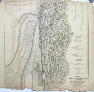
Sold2017Map of the Siege of Vicksburg, MississippiMap: Map of the Siege of Vicksburg, Mississippi Description: This large battle map identifies Union and Confederate entrenchments. It is very detailed, showing the roads, streets, houses, railroads, vSee Sold Price
Sold2016Chancellorsville Campaign and DranesvilleMap: Chancellorsville Campaign and Dranesville, Atlas to Accompany the Official Records of the Union and Confederate Armies Maker: The United States War Department Printer: Julius Bien & Company, WashSee Sold Price
Sold202319th century. A clean original Julius & Bien CO, NY map of Missouri, 1865. Plate CLII. Atlas to19th century. A clean original Julius & Bien CO, NY map of Missouri, 1865. Plate CLII. Atlas to accompany the official records of the Union and Confederate Armies, 1861-1865. Measures 29.5 x 19 inchesSee Sold Price
Sold2021Two 19th Century American MapsA map that describes the Atlanta Campaign from the Atlas of the official records of the Union and the Confederate Armies, published by Julius Bein and Co. And an Dutch map that depicts Dakota, Iowa, NSee Sold Price
2022MAP antique SAVANNAH GA GENERAL SHERMAN ARMY CIVIL WAR 1864 OPERATIONS CAMPAIGNOriginal Lithograph Plate LXX (70) of the 175 Plates of The Official Folio Historical Record of The Official Atlas to Accompany the Official Records of the Union and Confederate Armies, Ordered by ActSee Sold Price
Sold202319th century. A clean original Julius & Bien CO, NY map of the Campaign of the Army of West19th century. A clean original Julius & Bien CO, NY map of the Campaign of the Army of West Mississippi, 1865. Plate CX. Atlas to accompany the official records of the Union and Confederate Armies, 18See Sold Price
Sold202319th century. A clean original Julius & Bien CO, NY map of the USA Boundaries of the Union and19th century. A clean original Julius & Bien CO, NY map of the USA Boundaries of the Union and Confederates Geographical Divisions and Departments, June 30, 1864. Plate CLXIX. Atlas to accompany the oSee Sold Price
Sold20221909 Stonewall Jackson American Civil War Confederate Battle MAPS Henderson1909 Stonewall Jackson American Civil War Confederate Battle MAPS Henderson An incredible, American edition of Hendersons biography on the celebrated Civil War general, Thomas Stonewall Jackson. ThisSee Sold Price
Sold2019Civil War Atlas, Boundaries Union and ConfederateCivil War Atlas, Boundaries Union and Confederate Divisons and Departments,"1863, Plate 167, H. - 18 1/2 in., W. - 29 1/2 in.See Sold Price
Sold2019Civil War Atlas, Boundaries Union and ConfederateCivil War Atlas, Boundaries Union and Confederate Divisions and Departments," 1862, Plate 166, H. - 16 in., W. - 27 in.See Sold Price
Sold20231899 1ed Life of Stonewall Jackson Campaigns Civil War Battles Confederate Maps1899 1ed Life of Stonewall Jackson Campaigns Civil War Battles Confederate Maps A scarce, childrens educational work by Mary L. Williamson on the life and military career of “Stonewall” JaSee Sold Price
Sold20211903 Stonewall Jackson and Civil War Confederate Battle1903 Stonewall Jackson and Civil War Confederate Battle Maps Henderson 2v An incredible, American edition of Henderson’s biography on the celebrated Civil War general, Thomas ‘StonewallâSee Sold Price
Sold20191866 1ed Stonewall Jackson Life & Campaigns Civil War1866 1ed Stonewall Jackson Life & Campaigns Civil War Confederate Battle Maps “Dabney’s biography belongs near the top of any checklist of Jackson literature.” (Nevins) An incredible, first AmerSee Sold Price
Sold2016Civil War Map of Secessionville, James IslandTitle: Map of the Engagement At Secessionville James Island, S.C. June 16, 1862 Maker: Washington Government Printing Office Date:1892 Civil War Map showing Union and Confederate troop locations and mSee Sold Price
Sold2017The Position of Yorktown and the ApproachesWashington Government Printing Office 1892. Civil War Map showing Union and Confederate troop locations and movement Size: 29 x 18 inches No Reserve: This lot starts at $1 and has no reserve as a courSee Sold Price
Sold2017Bien: Antique Map of the US, Union & Confederate, 1895Item: Map of the United States of America showing the boundaries of the Union and Confederate geographical divisions and departments, Dec. 31, 1860 Maker: Julius Bien & Co Size: 28 x 17 inches Date: 1See Sold Price
Sold2016Civil War Diorama with Lead Soldier BattlefieldUNITED STATES, 20TH CENTURY The diorama depicting a Civil War battle between the Union and Confederate army. The painted lead soldiers are glued to landscape wooden board along with battlefield gear,See Sold Price
Sold20241888 CIVIL Camp-Fire Sketches Battle-Field Echoes WAR History Union Confederate1888 CIVIL Camp-Fire Sketches Battle-Field Echoes WAR History Union Confederate “Camp-Fire Sketches and Battle-Field Echoes of the Rebellion,” edited by William C. King and W.P. Derby, is a 19See Sold Price
Sold2019Civil War Atlas, United States Boundaries Showing UnionCivil War Atlas, United States Boundaries Showing Union and Confederate Divisiomns and Departtments," 1861, Plate 164, , H. - 18 1/4 in., W. - 29 1/2 in.See Sold Price
4 days LeftJasper521876 Bachelder View of Pickett's Charge at Gettysburg -- Battle of Gettysburg (Repulse of$550
May 14Fleischer's AuctionsGen. Sherman's Inscribed "Grant and Sherman: Their Campaigns and Generals"$200(3 bids)
4 days LeftJasper52c1863 Civil War era Virginia with Washington D.C. and View of The Capital. By C. Magnus$240
12 hrs LeftMatthew Bullock AuctioneersP. G. T. Beauregard, Confederate General, Confederate States of America$700
May 12Schilb Antiquarian Rare Books1890 HUGE Soldier in Our Civil War Illustrated Military Battles Lincoln FOLIO$12(3 bids)
12 hrs LeftMatthew Bullock AuctioneersPhilip H. Sheridan, Union General of the Army, Commanding Officer Army of the Potomac$170(1 bid)
May 04Trillium Antique Prints & Rare BooksCarey & Lea's .. American Atlas - Volume with 46 Originally Hand-colored Folio Maps$1,000(1 bid)


![[CIVIL WAR] Soldier's Antietam Relic Walking Stick (1 of 7)](https://p1.liveauctioneers.com/7226/325455/175169112_1_x.jpg?height=282&quality=70&version=1712370394)
![[CIVIL WAR] Died at Andersonville, Soldier & Wife (1 of 1)](https://p1.liveauctioneers.com/7226/325455/175169078_1_x.jpg?height=282&quality=70&version=1712370394)


![[Gettysburg] The Horrors of War (1 of 1)](https://p1.liveauctioneers.com/7226/325455/175169090_1_x.jpg?height=282&quality=70&version=1712370394)


![[CIVIL WAR] CSA Hymn Book Trophy of War (1 of 5)](https://p1.liveauctioneers.com/7226/325455/175169047_1_x.jpg?height=282&quality=70&version=1712370394)


![[CIVIL WAR] Artillery Brass Hat Insignia (1 of 2)](https://p1.liveauctioneers.com/7226/325455/175169042_1_x.jpg?height=282&quality=70&version=1712370394)


![[CIVIL WAR] Original Artillery Shell Jacket (1 of 3)](https://p1.liveauctioneers.com/7226/325455/175169043_1_x.jpg?height=282&quality=70&version=1712370394)
![[CIVIL WAR] Quilt Signed By Veterans (1 of 5)](https://p1.liveauctioneers.com/7226/325455/175169113_1_x.jpg?height=282&quality=70&version=1712370394)