Sold20171768 Millar Map of New York, Boston, Charleston,Title: 1768 Millar Map of New York, Boston, Charleston, Havana, Deleware River -- Plan of: the Harbour of New York; The Town and Harbour of Boston; River Deleware; Harbour of Charles Town; City and HaSee Sold Price
Sold2017Bradford: Antique Map of Early American Cities, 1835Title/Content of Map: Early American Cities: New York, Portland (MI), Boston, Providence, Baltimore, Albany, Philadelphia, Charleston, Savanna, New Orleans, St. Louis, Louisville, Nashville, CincinnatSee Sold Price
Sold2017Rare - 1768 Holland - Jeffreys Map of New York and NewThe rarest and earliest state of a seminal map. The Provinces of NEW YORK and NEW JERSEY with part of PENSILVANIA, and the Governments of TROIS RIVIERES, and MONTREAL: drawn by Capt. Holland. / A ChorSee Sold Price
Sold2017Millar: Map of Italy, 1768Map: 1768 Millar Map of Italy -- A New and Correct Map of Italy from the Latest Improvements and Regulated by Astronomical Observations Cartographer: G Millar Year/Place: 1768 (penciled) Dimensions: 1See Sold Price
Sold2017Millar Map of Scandinavia, 17681768 Millar Map of Scandinavia -- A New and Complete Map of Norway, Sweeden and Denmark. A nice, handsome map of the Scandinavian countries. From Millar's New Complete & Universal System of GeographicSee Sold Price
Sold2018Large lot early maps, New Orleans, Boston, New York,Large lot early maps, New Orleans, Boston, New York, Mamaroneck, also includes several atlas. All items sold as is as found, please refer to images for additional condition issues, all sales final.See Sold Price
Sold2017Millar: Antique Map of Spain & Portugal, 1768Title/Content of Map: 1768 Millar Map of Spain and Portugal -- A New and Complete Map of Spain and Portugal Date Printed: 1768 c. Cartographer: G Millar Size: 14.3 x 9.3 in. Condition: Good - fair. SeSee Sold Price
Sold2017Millar: Antique Map Netherlands Belgium Luxenburg, 1768Title/Content of Map: 1768 Millar Map of Netherlands, Belgium, Luxenburg -- A New and Accurate Map of the Seven United Provinces Imcluding the Dutch Netherlands & e. Date Printed: 1768 Cartographer: GSee Sold Price
Sold2022Vintage Travel Destination Maps & EphemeraThere is a 1949 Rand McNally road atlas, 40+ vintage maps including locations such as New York, Pittsburgh, Boston, Ohio, Pennsylvania, New Jersey, advertising ephemera for various companies includingSee Sold Price
Sold2023West Shore Railroad Timetable and Map, 1897 [159580]West Shore Railroad timetable and map printed by Wynkoop Hallenbeck Crawford & Co. in June 1897. Map shows the Niagara Falls Route to New, York, Boston, Chicago, and St. Louis. Map is printed in colorSee Sold Price
Sold2023`1903 Scarborough Railroad Map of New York1903 "Scarborough's New Railroad Map of the State of New York, printed by the National Publishing Company Boston, Mass. in overall good condition 41.5" x 52See Sold Price
Sold2019Map of New York and VicinityTitle: Map of New York and Vicinity Publication Date: 1896 Cartographer: CRAM, GEORGE F. Publisher: GEORGE F. CRAM Size: 18.6Height - 12.25Width Detailed plan. On reverse, plans of Boston and BrooklynSee Sold Price
Sold2019Twelve Books on Regional American FurnitureIncluding the furniture of New York, Charleston, Baltimore, Chicago, and Boston. All books sold "as is." No guarantees made about number of books in lot or condition of books. No returns or refunds.See Sold Price
Sold2017Civil War Era Map of Charleston, SC and EnvironsE & G. W. Blunt's Map of Charleston and Vicinity (New York: E & G. W. Blunt, 1862), a handy map for military purposes showing both land and sea routes in the region. Unframed in a 1950s mailing/storagSee Sold Price
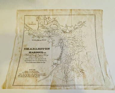
Sold2024Charleston Harbour map- Blunt 1833 mapCharleston Harbour map marked from New York published by E and G W. Blunt 1833. Engraved by William HookerSee Sold Price
Sold2017US Canada Atlantic & Great Lakes Ports Sea Chart, 1914Title/Content of Map: 'American Atlantic Ports - North Sheet; Inset Chicaco; Boston Harbour; Soo Canals; New York Horbour; Ontario; The Coast from New York to Boston; Buffalo; Montreal; Halifax; NewfoSee Sold Price
Sold2018GROUP LOT OF PAPER GOODS(5) INCLUDING - TWO BRUCKTOWN AND PLYMOUTH RAILWAY CO. MAPS - WIARD PLOW ADV. - "VIEWS OF FALL RIVER LINE" NEW YORK TO BOSTON - 1876 CENTENNIAL SOUVENIR, PHILADELPHIA , 3 1/4" TO 6 1/2" HSee Sold Price
Sold20194 ANTIQUE BOOKS DUMAS +1- A Bed of Roses W.L. George published by Modern Library, 1919. Soft Cover. 2- Duma's La Tulipe Noire Published by D. C. Heath & CO., Boston New York Chicago (1899). 3- Owen Meredeth Lucille publisheSee Sold Price
Sold2019[AMERICAN STATESMAN]. €“ MORSE, John T. (1840-193[AMERICAN STATESMAN]. €“ MORSE, John T. (1840-1937). Abraham Lincoln. Boston and New York: Houghton Mifflin Company, 1893. 2 volumes, 8vo (180 x 115 mm). Folding map to volume one. Contemporary haSee Sold Price
Sold2022BOOKS ON WORLD TRAVELERS AND ADVENTURERSOur New Way Round the World by Coffin, Boston, Fields 1869, Expedition to Borneo by Keppel New York, Harper 1846, (map), Letters from the West Indies b y Hovey, New York, Gould and Newman 1838, SailorSee Sold Price
Sold2020Two Currier & Ives PrintsAutumn Fruits and Summer Fruits each 15 1/2" x 19" stone lithographs and a Map of the State of New York by J. Denison, published by Thomas & Andrews, Boston, 1796See Sold Price
Sold2024Group of Two 19th Century Railroad BooksGroup of Two 19th Century Railroad Books Pathfinder Railway Guide for the New England States, 1856, published by Geo. K. Snow, Boston 1849 Goldthwait Railroad Map of New England and Eastern New York,See Sold Price
Sold20211855 MAP THE CITY OF CHARLESTON, SOUTH CAROLINAMap of the City of Charleston, South Carolina , published by JH Colton & Co, New York in 1855. Good condition. Paper size 11 1/2"x7". Professionally framed and matted. In frame 11 1/2"x15 1/2"x1". WeiSee Sold Price
Sold2023First American Revolutionary War Battle Map, from Nathan Daboll, Freebetter's New-England Almanacks,American Revolution First American Printing of a Revolutionary War Battle Map Titled: "A VIEW of the Present Seat of War, at and near New-York." by Nathaniel Low, Printed by John Gill, Boston 1777-DatSee Sold Price
Oct 19Sunstone Auction HouseEUGENE O'NEILL Signed 1934 THE WILDERNESS EDITION Limited Edition #584 of 770$50
15 hrs LeftJasper52NEW YORK CITY antique town city map plan. Manhattan Brooklyn Jersey. SDUK 1844$600
Oct 04Mynt AuctionsWade Boggs Signed Baseball HOF 2005 Rawlings MLB New York Yankees Boston Red Sox$10
15 hrs LeftJasper52An accurate Map of New York, in North America… Universal Magazine 1780 old$550
5 days LeftATTIC TO AUCTION, LLCJoe DiMaggio, Mickey Mantle, Ted Williams New York Yankees/Boston Red Sox 38x32 inch framed with 4 i$25
1 day LeftSwann Auction GalleriesVARIOUS CARTOGRAPHERS Group of 10 lithographed folding maps and plans taken from various editions of$375


![West Shore Railroad Timetable and Map, 1897 [159580]: West Shore Railroad timetable and map printed by Wynkoop Hallenbeck Crawford & Co. in June 1897. Map shows the Niagara Falls Route to New, York, Boston, Chicago, and St. Louis. Map is printed in color](https://p1.liveauctioneers.com/2699/274463/144089090_1_x.jpg?height=310&quality=70&version=1672966071)


![[AMERICAN STATESMAN]. €“ MORSE, John T. (1840-193: [AMERICAN STATESMAN]. €“ MORSE, John T. (1840-1937). Abraham Lincoln. Boston and New York: Houghton Mifflin Company, 1893. 2 volumes, 8vo (180 x 115 mm). Folding map to volume one. Contemporary ha](https://p1.liveauctioneers.com/197/147290/74414212_1_x.jpg?height=310&quality=70&version=1564780494)