Sold2017Framed Map of North AmericaFramed Map of the North American Continent. Marked “Map Produced by Allan Cartography of Medford, Oregon, with the assistance of Dr. A. Jon Kimerling, Department of Geosciences, Oregon State UniversSee Sold Price
Sold20171846 Mitchell hand-colored map of North CarolinaFeatures an inset of the Gold Region. Clean and highly collectible map of the Tar Heel state. When matted and framed this map will become a lovely, cherished specimen of wall art that is actually a piSee Sold Price
Sold2018Two Civil War Era Mitchell MapsMap of North America Showing Its Political Divisions and county maps of North Carolina, South Carolina, and Florida on one sheet (Philadelphia: S. Augustus Mitchell, 1860). Not framed. 15.25 x 12.25 iSee Sold Price
Sold20211796 MAP OF NORTH & SOUTH CAROLINA, DENISON, FRAMEJ. Denison (American, 18th century). "Map of North and South Carolina" -1796, from "Morse's Universal Geography", engraving. Framed. Provenance: From the Lifetime Collection of Billy S. Arant, Jr., ChSee Sold Price
Sold2017Framed Decorative Celestial Mapreproduction print, presented in painted frame with gilt beaded decoration. DOA 28 x 28 in. Private Collection, Charlotte, North Carolina. Additional high-resolution photos are available at LelandLittSee Sold Price
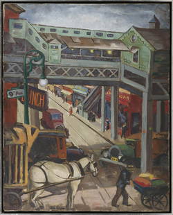
Sold2021JOHN OPPER (New York/North Carolina/Illinois,JOHN OPPERNew York/North Carolina/Illinois, 1908-1994Chicago scene with the “L” at 9th Ave. Signed lower left “John Opper”.Oil on canvas, 29.5” x 23.5”. Framed 31” x 25”.See Sold Price
Sold2018North Carolina & South Carolina by MitchellTitle/Content of Map: North Carolina & South Carolina by Mitchell Date: 1869 Cartographer: Augustus S. Mitchell Material/Medium: Paper Size: 14" x 16" Provenance: New York Published in Philadelphia inSee Sold Price
Sold2018Colton: Antique Map of North Carolina, 1859Title/Content of Map: North Carolina Date Printed: 1859 Cartographer: H.J. Colton Material/Medium: Paper Size: 17 1/2" x 15" Hand colored,engraved. Published in New York in 'Colton's General Atlas.' PSee Sold Price
Sold2017Tanner: Antique Map of North Carolina, 1843Title/Content of Map: North Carolina by Tanner Date Printed: 1843 Cartographer: based on the work of H.C. Tanner Material/Medium: Paper Size: 17" x 14" Hand colored engraved Map. From the first editioSee Sold Price
Sold2024North Carolina 1896Title/Content of Map: North Carolina 1896 Date Printed: 1896 Material/Medium: Paper Size: Approx. 11"x14" Additional Info: Rand, McNally & Co. Reserve: $35.00 Shipping: Domestic: Flat-rate of $15.00 tSee Sold Price
Sold2016(4) 1838 BRADFORD Maps: NC, SC, GA, FL.[United States/South] 4 Maps. ++ NORTH CAROLINA. ++ SOUTH CAROLINA. ++ GEORGIA. ++ FLORIDA. ++ +Maps 28, 30, 31, 32 from T. G. Bradford, “An Illustrated Atlas, Geographical, Statistical, And HistoriSee Sold Price
Sold2023Emanuel Bowen Map North & South Carolina, Georgia[Emanuel Bowen Map of North & South Carolina and Georgia] , "A New & Accurate Map of the Provinces of North & South Carolina Georgia & c. Drawn from late Surveys and regulated by Astron Observat. By ESee Sold Price
Sold2022Nice example of ext. scarce map of North Carolina (1814)Extremely scarce map of Samuel Lewis map of North Carolina, appearing in the extremely scarce 1816 edition of Carey’s General Atlas (same map as in the 1814 Carey atlas). Early nineteenth centurSee Sold Price
Sold2023Framed map of North America - possibly a book plate - overall framed size -13"x15"Framed map of North America - possibly a book plate - overall framed size -13"x15"See Sold Price
Sold2021Beautiful 1854 map of North Carolina, Cowperthwait“A New Map of Nth Carolina with its Canals, Roads & Distances from Place to Place along the Stage & Steam Boat Routes” published in a scarce 1854 edition of “A New Universal AtlasSee Sold Price
Sold20201804 Arrowsmith and Lewis Map of North Carolina --Title: 1804 Arrowsmith and Lewis Map of North Carolina -- North Carolina Cartographer: Arrowsmith and Lewis Year/Place: 1804, Philadelphia Dimensions: 7.8 X 9.8 in. Descriptions: This is a very nice eSee Sold Price
Sold2022Scarce 1st ed. Colton RR map of North CarolinaLovely example of North Carolina map from the first edition of Colton’s Atlas of the World. One of the few mid-19th century maps to show North Carolina independently—it was more often mappSee Sold Price
Sold20232 Framed Historical Maps, North America & Kentucky, Carey & Lea1st item: Geographical, Statistical & Historical map of North America, 1823, published by Henry Charles Carey (1793-1879) and Isaac Lea (1792-1886) Philadelphia, illustrated by J. Yeager. From A ComplSee Sold Price
Sold2021Large Map of North Carolina and South CarolinaLarge Map of North Carolina and South Carolina With map of Georgia and Florida[separately] on versos Cartographer: George Franklin Cram Dated: Circa 1900See Sold Price
Sold20181855 Colton Map of North Carolina -- Colton's NorthTitle/Content of Map: 1855 Colton Map of North Carolina -- Colton's North Carolina Date: 1855 New York Cartographer: J Colton Size: 12.9 X 16.4 in. An excellent and somewhat rare map of North CarolinaSee Sold Price
Sold20231855 Cowperthwait map of North CarolinaA New Map of North Carolina with its Canals, Roads & Distances from Place to Place along the Stage & Steam Boat Routes. Shows and highlights railroad routes, towns, rivers, topography, roads, mountainSee Sold Price
Sold20211855 Colton Map of North Carolina -- North CarolinaTitle: 1855 Colton Map of North Carolina -- North Carolina Cartographer: J Colton Year / Place: 1855, New York Map Dimension (in.): 11.8 X 15.5 in. This is a very nice map of North Carolina with insetSee Sold Price
Sold2018FRAMED MAP, GERMANY NORTH OF THE MAYNEFramed map, "Germany, North of the Mayne", drawn and engraved for Thomson's New General Atlas, 1816, London engraved, hand colored highlights, sight approx: 20"h, 24.5"w, overall: 30"h, 34.5"w, 10.5lbSee Sold Price
Sold20221855 Colton Map of North Carolina -- North CarolinaTitle: 1855 Colton Map of North Carolina -- North Carolina Cartographer: J Colton Year / Place: 1855, New York Map Dimension (in.): 11.8 X 15.5 in. This is a very nice map of North Carolina with insetSee Sold Price
4 days LeftLeland LittleEmanuel Bowen (English, 1697-1767), Map of the American Southeast$100(2 bids)
Jul 06Case Antiques, Inc. Auctions & Appraisals5 TVA Map Books incl. Tennessee & New York c. 1935-1950$250
4 days LeftSwann Auction Galleries(CIVIL WAR--PRINTS.) Ethan Blodgett. Map of a Portion of Roanoke Island, Showing the Battlefield of$750
2 days LeftMynt Auctions1947 Morgan State vs. North Carolina State Proof Ticket 10/11/47 Polo Grounds$10
3 days LeftMynt AuctionsCHARLIE SCOTT USA 68 GOLD MEDAL NORTH CAROLINA CELTICS JSA/COA SIGNED JERSEY$10


![(4) 1838 BRADFORD Maps: NC, SC, GA, FL.: [United States/South] 4 Maps. ++ NORTH CAROLINA. ++ SOUTH CAROLINA. ++ GEORGIA. ++ FLORIDA. ++ +Maps 28, 30, 31, 32 from T. G. Bradford, “An Illustrated Atlas, Geographical, Statistical, And Histori](https://p1.liveauctioneers.com/179/85723/44107998_1_x.jpg?height=310&quality=70&version=1457209205)
![Emanuel Bowen Map North & South Carolina, Georgia: [Emanuel Bowen Map of North & South Carolina and Georgia] , "A New & Accurate Map of the Provinces of North & South Carolina Georgia & c. Drawn from late Surveys and regulated by Astron Observat. By E](https://p1.liveauctioneers.com/268/293228/155705053_1_x.jpg?height=310&quality=70&version=1687296979)


![Large Map of North Carolina and South Carolina: Large Map of North Carolina and South Carolina With map of Georgia and Florida[separately] on versos Cartographer: George Franklin Cram Dated: Circa 1900](https://p1.liveauctioneers.com/5614/198722/101907570_1_x.jpg?height=310&quality=70&version=1618847492)


