Sold20171846 Mitchell hand-colored map of North CarolinaFeatures an inset of the Gold Region. Clean and highly collectible map of the Tar Heel state. When matted and framed this map will become a lovely, cherished specimen of wall art that is actually a piSee Sold Price
Sold2020Florida & North CarolinaTitle: Florida & North Carolina Date/Period: 1862 Materials: steel engraved Dimensions: 15 1/2” x 12 1/2” By Augustus S. Mitchell. Hand colored engraved map. From ‘the New General Atlas’. PublSee Sold Price
Sold2022North America, 1846. By MitchellTitle: North America, 1846. By Mitchell Date/Period: 1846 Materials: Hand colored engraved Size: 11 1/2 x9" Interesting maps gives a impression of a independent upper California region. While dated 18See Sold Price
Sold2017Mitchell: Hand Colored Map of North America, 1854Map: Hand Colored Map of North America Maker: Samuel Augustus Mitchell Date: 1854 Size: Approx. 8.5x10.5 inches Hand colored. From the 1854 Mitchell's School Atlas by Samuel Augustus Mitchell in the 1See Sold Price
Sold20161846 Mitchell Map of Ohio, Indiana, & IllinoisDESCRIPTION: 1846 S. Augustus Mitchell handcolored fold out pocket map of the states of Ohio, Indiana, and Illinois with the settled parts of Michigan and Wisconsin. Includes original portfolio. MEASUSee Sold Price
Sold20231846 Framed "A New Map of New York" State MapHand colored map by Mitchell of 1846. Drawn on French marble paper, hand finished frame with gold leaf. Frame measures approximately 24.5" x 22.25". Estimated shipping cost for this auction lot is $50See Sold Price
Sold2018Colton: Antique Map of North Carolina, 1859Title/Content of Map: North Carolina Date Printed: 1859 Cartographer: H.J. Colton Material/Medium: Paper Size: 17 1/2" x 15" Hand colored,engraved. Published in New York in 'Colton's General Atlas.' PSee Sold Price
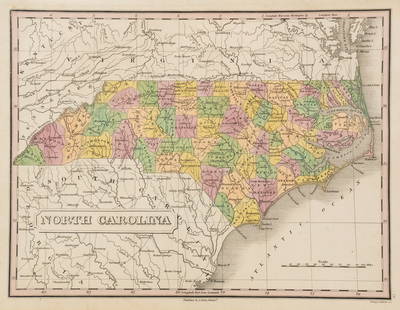
Sold2017Tanner: Antique Map of North Carolina, 1843Title/Content of Map: North Carolina by Tanner Date Printed: 1843 Cartographer: based on the work of H.C. Tanner Material/Medium: Paper Size: 17" x 14" Hand colored engraved Map. From the first editioSee Sold Price
Sold2017Colton: Antique Map of North Carolina, 1861Title/Content of Map: Colton's North Carolina Date Printed: 1861 Cartographer: J.H. Colton Material/Medium: Paper Size: 14" x 17" Hand colored, steel engraved. From 'Colton's General Atlas. PublishedSee Sold Price
Sold2023Three 19th Century MapsAn English hand colored map of North American, a hand colored map of South America dated 1839 by Samuel Augustus Mitchell and a hand drawn and colored map of South America. All framed. Dimensions:TheSee Sold Price
Sold2017Johnson’s Civil War era map of North & South CarolinaHistoric map shows the Carolinas in great detail shortly following the outbreak of the Civil War. States hand-colored at the time of publishing with color coding according to county. Inset map depictsSee Sold Price
Sold2022Group of Four 19th Century North Carolina Mapsfour maps, engravings on wove paper with hand colored highlights, including: Jean Alexandre Buchon, Carte Geographique, Statistique Et Historique De La Caroline Du Nord, Paris, 1825, unframed; MatthewSee Sold Price
Sold2023HERMAN MOLL (ENGLISH, C. 1654-1732) MAP OF NORTH AND SOUTH CAROLINAHERMAN MOLL (ENGLISH, C. 1654-1732) MAP OF NORTH AND SOUTH CAROLINA, hand-colored engraving on laid paper, titled "CAROLINA / By / H. Moll Geographer" in a rectangular cartouche along lSee Sold Price
Sold2022Six 19th Century Maps of North and South Carolinasix maps, engravings on wove paper, some with hand colored highlights, all unframed, including: three examples of Frank Gray, Gray's New Map of North and South Carolina, Philadelphia, circa 1881; JohnSee Sold Price
Sold2018Mitchell Map of North America, 1850Excellent hand colored, engraved map of the North American continent originally created by S. Augustus Mitchell in 1850. Thomas, Cowperthwait & Co. bought out Mitchell that year. They published this mSee Sold Price
Sold2023Anthony Finley North Carolina Counties MapA Anthony Finley (American, 1784-1834) handcolored engraving depicting the counties within North Carolina and the surrounding areas. Stamped 'Published By A. Finley Phliad.' lower center. Presented inSee Sold Price
Sold2023Early 1900's Railway Mail Service Map, Virgina, North CarolinaDated 1910, hand-colored Third Division Railway Mail Service map, showing railway mail service lines in West Virginia, Virginia & North Carolina. Engraver: Fisk, E. F. Cartographer: International CorrSee Sold Price
Sold2022ANTIQUE MAPS, 3 PCS, H 6.25"-14.75", CHARLESTON, SAVANNAH & YORKSHIREANTIQUE MAPS, 3 PCS, H 6.25"-14.75", CHARLESTON, SAVANNAH & YORKSHIRE A selection of three antique maps. Includes one hand-colored 'Parts of North and South Carolina' coastal map (H 14.75" x W 13"), oSee Sold Price
Sold2022Mitchell map of North America, 1860Decorative map of North America, hand-colored by country. Shows recent discoveries in Russian America, including McClure's northwest passage aboard the Investigator. Nebraska Territory is shown goingSee Sold Price
Sold2020Antique Maps by Augustus Mitchell (8)Various maps, including North America, South America, Europe, Italy, Spain, Greece, Brazil. Hand-colored engravings. S. Augustus Mitchell, Philadelphia, c. 1850. 17 1/2" x 14 1/4".See Sold Price
2020North and South CarolinaTitle/Content of Map: North and South Carolina Date: 1861 Cartographer: Johnson Material/Medium: steel engraved Size: 28x18”Provenance: New York Hand colored Reserve: $35.00 Shipping: DomesticSee Sold Price
Sold2022Three in one world and Antarctica map 1846 by MitchellTitle: Three in one world and Antarctica map 1846 by Mitchell Date/Period: 1846 Materials: Hand colored engraved Size: 11 1/2 x9" Three maps are the subject with the top on equatorial projection and tSee Sold Price
Sold2022German States Pre unification, Austria, Czechia, Switzerland and northern Italy. 1846 by MitchellTitle: German States Pre unification, Austria, Czechia, Switzerland and northern Italy. 1846 by Mitchell Date/Period: 1846 Materials: Hand colored engraved Size: 11 1/2 x9" Detailed maps shows the varSee Sold Price
Sold2018Graessl: Antique Map of U.S. Southeast with city insetsDie Staaten N. & S. Carolina Georgia & Florida. A fascinating and beautifully colored map of the southeastern states of the U.S. in 1846, with inset maps of the "Gold Region of North Carolina" and theSee Sold Price
May 18Blackstone Valley Auctions & Estates LLCRevolutionary Era War Map of the Attack on Ft. Moultrie.$100
5 hrs LeftTrillium Antique Prints & Rare BooksMitchell's A New Universal Atlas.. - Volume with 73 Maps$1,000(1 bid)
5 days LeftHunt and Peck Estate Services, Inc.ANTONIO ZATTA (ITALIAN, 18TH CENTURY) MAP OF VIRGINIA$70(1 bid)
May 11Fichter KunsthandelJ. HOMANN (1664-1724), Totius Americae, Map of America, around 1710, Copper engraving€800
May 11Fichter KunsthandelP. SCHENK (*1693) after ZÜRNER (*1679), Map of Dresden and surroundings, before 1725, Copper en€200
5 hrs LeftTrillium Antique Prints & Rare BooksCarey & Lea's .. American Atlas - Volume with 46 Originally Hand-colored Folio Maps$1,000(1 bid)
May 11Trillium Antique Prints & Rare BooksCatesby, Folio - Kingfisher with Narrow Leaved Candleberry Myrtle. 1-69$200