Sold20191886 California from Mitchell atlasFine antique lithograph map with original hand color. “County Map of the State of California” by William Bradley and found in the 1887 Mitchell New General Atlas. Detailed, scarce and interestingSee Sold Price
Sold2017Perthes: Stieler's Antique School Atlas with Maps, 1865Map: Stieler's Schul-Atlas Uber Alle Theile Der Erde Cartographer: Stieler / J. Perthes Place & Date: Gotha / 1865 Size: 12" x 9 1/2" (each map) Condition: original outline color; overall age toning;See Sold Price
Sold2023Antique Map of Hell Gate and East River - 1887Original, extremely rare first edition map (1887), full title "Hell Gate and East River from S. End of Blackwell's Island to Lawrence's Point including Little Hell Gate and Mouth of Harlem River." ProSee Sold Price
Sold2021Lot Of 1940s Maps and Tourism BrochuresThis is a collection of maps and attractions brochures from the 1940s. Most from Florida, but there are also road maps from Indiana, Mississippi, Alabama. They all come in the original little case theSee Sold Price
Sold2017Wharton Esherick three-legged stoolWharton Esherick (Paoli, PA, 1887-1970) walnut and hickory three-legged stool in original patina with sculpted seat, through tenon construction, initials and date carved under seat: "WE 1960". 16-1/4"See Sold Price
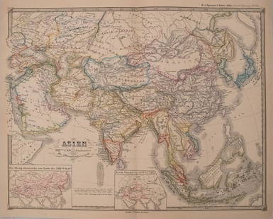
Sold2017Perthes: Antique Map of Asia in 15th Century, 1855Map: 1855 Perthes Map of Asia in 15th Century -- Asien gegen die Mitte des Funften Jahrhunderts... Date Printed: 1855, Gotha Cartographer: J Perthes Size: 12.9 x 16.5 in. Condition: Very good-excellenSee Sold Price
Sold2017Perthes: Antique Map of Asia in 13-14th Centuries, 1855Map: 1855 Perthes Map of Asia in the 13th and 14th Centuries -- Asien im XIII-ten & XIV-ten Jahrhundert… Date/Place: 1855, Gotha Cartographer: J Perthes Size: 12.7 x 16 in. Condition: Very good-exceSee Sold Price
Sold2022Four Antique MapsLot of 4 antique maps. Original, Environs of Paris. Colton, 1855 12-1/2" x 15-3/4". Original Spain and Portugal J Rapkin. 1852, 9-1/2" x 12-1/2". Original The World, J Colton, New York 18-3/8" x 29".See Sold Price
Sold2019BORNEO & THE PHILIPPINE ISLANDS. East Indies. ManilaTITLE/CONTENT OF MAP: 'Borneo; The Philippine Islands' DATE PRINTED: 1863 IMAGE SIZE: Approx 32.0 x 43.5cm, 12.5 x 17.25 inches (Large) TYPE: Antique map with original outline colour CONDITION: Good;See Sold Price
Sold2018BELFAST ENVIRONS. Lough Lurgan Lisburn Carrickfergus.Reserve Reduced! TITLE/CONTENT OF MAP: 'The Environs of Belfast' DATE PRINTED: 1863 IMAGE SIZE: Approx 32.5 x 46.5cm, 12.75 x 18.25 inches (Large) TYPE: Antique map with original outline colour CONDITSee Sold Price
Sold2024BORNEO & THE PHILIPPINE ISLANDS. East Indies. Manila Zebu/Cebu. WELLER 1863 mapTITLE/CONTENT OF MAP: 'Borneo; The Philippine Islands' DATE PRINTED: 1863 IMAGE SIZE: Approx 32.0 x 43.5cm, 12.5 x 17.25 inches (Large) TYPE: Antique map with original outline colour CONDITION: Good;See Sold Price
Sold2023PACIFIC OCEAN Sandwich Islands/Hawaii Australia New Zealand &c. WELLER 1863 mapTITLE/CONTENT OF MAP: 'The Pacific Ocean' DATE PRINTED: 1863 IMAGE SIZE: Approx 47.0 x 65.0cm, 18.5 x 25.75 inches (Large); Please note that this is a folding map. TYPE: Antique map with original outlSee Sold Price
Sold2018Weller: Antique Map of Tasmania or Van Diemen's LandTitle/Content of Map: 'Tasmania or Van Diemen's Land' Shows townships not yet settled. Date Printed: 1863 Image Size: Approx 44.5 x 31.5cm, 17.5 x 12.25 inches (Large) Type: Antique map with originalSee Sold Price
Sold2018Weller: Antique Map of Dublin Environs, 1863Title/Content of Map: 'The Environs of Dublin' Wicklow Mountains. Railways. Ireland. Date Printed: 1863 Image Size: Approx 43.5 x 32.5cm, 17.25 x 12.75 inches (Large) Type: Antique map with original oSee Sold Price
Sold2023NORTHERN CENTRAL AMERICA. Mexico Belize Guatemala Honduras. ETTLING 1863 mapCentral America (Northern Part) Comprising Mexico, Guatemala, Honduras, San Salvador and Nicaragua' by Drawn & Engraved by T. Ettling (1863). Antique map with original outline colour, 31.5 x 44.0cm, 1See Sold Price
Sold2017Weller: Map of Afghanistan & Beloochistan, 1863Map: 'Afghanistan, Beloochistan, Pakistan. Kabul Karachi Quetta.' Date Printed: 1863 Image Size: Approx 43.5 x 31.0cm, 17.25 x 12.25 inches (Large) Type: Antique map with original outline colour CondiSee Sold Price
Sold2018SOUTHERN CENTRAL AMERICA. Mosquito New GranadaTITLE/CONTENT OF MAP: 'Central America (Southern Part) Including Venezuela & New Granada' Date: 1863 IMAGE SIZE: Approx 32.0 x 45.5cm, 12.5 x 18 inches (Large) TYPE: Antique map with original outlineSee Sold Price
Sold2018Ettling: Antique Map of Upper Canada, 1863TITLE/CONTENT OF MAP: 'Upper Canada' Lakes Huron, Erie & ONTARIO. Counties. Railways. DATE PRINTED: 1863 IMAGE SIZE: Approx 32.0 x 44.5cm, 12.5 x 17.5 inches (Large) TYPE: Antique map with original ouSee Sold Price
Sold20191872 Antique Map Historic France in 1483 Louis XI ParisIt is an authentic Antique map with original hand-coloring as issued. It is from M.N. Bouillet's Atlas Universel d'Histoire et de Geographie, published in Paris by the Librairie Hachette, 1872. The naSee Sold Price
Sold2023South America by John Dower. Gran Colombia. La Plata. Brazil 1845 old mapTitle: South America by John Dower. Gran Colombia. La Plata. Brazil 1845 old map Description: South America' by John Dower (1845). Antique map with original hand colouring, 28.0 x 22.5cm, 11 x 8.75 inSee Sold Price
Sold2018CORNWALL. Antique county map. Railways. Bodmin Moor.TITLE/CONTENT OF MAP: 'Cornwall; Inset map of Scilly Islands' DATE: 1863 IMAGE SIZE: Approx 32.0 x 43.5cm, 12.75 x 17 inches (Large) TYPE: Antique map with original outline colour CONDITION: Good; suiSee Sold Price
2018THE SHETLAND ISLANDS. Scotland. Edward WELLER. DispatchTITLE/CONTENT OF MAP: 'The Shetland Islands' DATE PRINTED: 1863 IMAGE SIZE: Approx 25.0 x 32.0cm, 9.75 x 12.5 inches (Large) TYPE: Antique map with original outline colour CONDITION: Good; suitable foSee Sold Price
Sold2023South America'. La Plata Bolivia w/ littoral New Granada. ETTLING 1862 mapTitle: South America'. La Plata Bolivia w/ littoral New Granada. ETTLING 1862 map Description: South America' by Drawn & Engraved by T. Ettling (1862). Antique map with original outline colour, 66.5 xSee Sold Price
Sold2018SUMATRA & JAVA. Dutch East Indies. Singapore.TITLE/CONTENT OF MAP: 'Sumatra; Java' DATE PRINTED: 1863 IMAGE SIZE: Approx 32.0 x 45.5cm, 12.75 x 18 inches (Large) TYPE: Antique map with original outline colour CONDITION: Good; suitable for framinSee Sold Price
5 days LeftJasper52SCANDINAVIA.Shows early railways inc Oslo-Eidsvoll.Norway Sweden.LOWRY 1863 map$25
5 days LeftJasper52MEDITERRANEAN SEA. Submarine telegraph cables. steamship routes. LOWRY 1863 map$55
May 22Hannam's Auctioneers LtdKershaw Patent Reflex ANTIQUE CAMERA w/ Original Case & Slides. 30 cm x 20 cm.£5
5 days LeftJasper52Decorative copperplate map of EUROPE by George A COOKE with original colour 1817$60
5 days LeftJasper52Central Europe roads canals railways Germany, Holland & Belgium. HUGHES 1856 map$25
5 days LeftJasper52ANCIENT CENTRAL EUROPE. Vindelicia Noricum Rhaetia Pannonia. ARROWSMITH 1828 map$30
May 22Hannam's Auctioneers LtdThowe KW Klappkamera ANTIQUE CAMERA w/ Original Leather Case & Slides. 20 cm x 14 cm.£5
Featured4 days LeftJasper52Mitchell’s Map of Asia showing travel routes London, India, China & Japan, 1860$45