Sold2017Perthes: Antique Map of Asia in 15th Century, 1855Map: 1855 Perthes Map of Asia in 15th Century -- Asien gegen die Mitte des Funften Jahrhunderts... Date Printed: 1855, Gotha Cartographer: J Perthes Size: 12.9 x 16.5 in. Condition: Very good-excellenSee Sold Price
Sold2017Perthes: Antique Map of Asia in 13-14th Centuries, 1855Map: 1855 Perthes Map of Asia in the 13th and 14th Centuries -- Asien im XIII-ten & XIV-ten Jahrhundert… Date/Place: 1855, Gotha Cartographer: J Perthes Size: 12.7 x 16 in. Condition: Very good-exceSee Sold Price
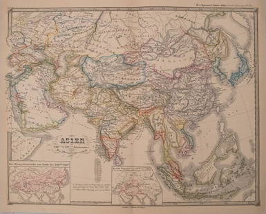
Sold2017Spruner: Antique Map of Asia, 1855Map: 1855 Spruner Map of Asia -- Asien im Xvten und XVIten Jahrhundrert… Cartographer: K v Spruner Year / Place: 1855 Dimensions: 12.8 x 16.5 in. Condition: Very Good to Excellent. On thick paper, sSee Sold Price
Sold2017Antique European Map Alsatia, 15th CenturyAntique European Map Alsatia. Hand colored accents 15th century map Latin descriptions. Ca 30x24 inches framed dimensions.Frame included with purchase. Please note that this lot has a confidential resSee Sold Price
Sold202217C. Jodocus Hondius Map of Asia Colored EngravingAntique 17th century map of Asia by Jodocus Hondius (Belgian Dutch, 1563-1612). Colored engraving originally published in 1631. Displayed in a wooden frame. Work Size: 15 x 19.5 in.SHIPPINGHill AuctioSee Sold Price
Sold2017A Blue and White Porcelain VaseA Blue and White Porcelain Vase, 14th/15th Century, H 28cmSee Sold Price
Sold2016A Blue and White Porcelain VaseA Blue and White Porcelain Vase, 14th/15th Century, H 42cmSee Sold Price
Sold2016A Blue and White Porcelain VaseA Blue and White Porcelain Vase, 14th/15th Century, H 28cmSee Sold Price
Sold2016A Copper Red Meiping Dragon VaseA Copper Red Meiping Dragon Vase, 14th/15th Century, H 42cmSee Sold Price
Sold2019A Blue and White Porcelain VaseA Blue and White Porcelain Vase, 14th/15th Century, H 28cmSee Sold Price
Sold2015An Excellent Blue and White VaseAn Excellent Blue and White Vase, 15th/16th Century, H 29cmSee Sold Price
Sold2016A Blue and White Porcelain VaseA Blue and White Porcelain Vase, 15th/16th Century, H 30cmSee Sold Price
Sold2016A Blue and White Porcelain VaseA Blue and White Porcelain Vase, 15th/16th Century, H 32cmSee Sold Price
Sold2016A Yellow Ground Meiping Dragon VaseA Yellow Ground Meiping Dragon Vase, 15th/16th Century, H35cmSee Sold Price
Sold2016A Blue and White Porcelain BowlA Blue and White Porcelain Bowl, 15th/16th Century, 40cm DiameterSee Sold Price
Sold2017A Blue and White Porcelain BowlA Blue and White Porcelain Bowl, 15th/16th Century, 30cm DiameterSee Sold Price
Sold2018Levasseur: Antique Map of Asia, 1852Title/Content of Map: 1852 Levasseur Map of Asia -- Asie Date Printed: 1852, Paris Cartographer: V. Levasseur Size: 11 x 16.5 in. A highly decorative nineteenth century map of Asia, dominated by RussiSee Sold Price
Sold2024An Antique Southeast Asian Terracotta Votive Tablet, 19th CenturyThis terracotta votive tablet is a devotional artifact hailing from pre-15th century Southeast Asia. It represents the historic art of crafting religious tablets, which played a crucial role in spiritSee Sold Price
Sold20231700s MAP of ASIA MINOR ARMENIA SYRIA SYCILY PERSIA antiqueMap of Asia Minor early 18th century hand colored Size 14 1/2 by 18 3/4" Very good condition Reserve: $160.00 Shipping: Domestic: Flat-rate of $25.00 to anywhere within the contiguous U.S. InternaSee Sold Price
Sold2022Corea and Japan by John Thomson. East Asia. Korea 1830 old antique map chartTITLE/CONTENT OF MAP: 'Corea and Japan' DATE PRINTED: 1830 IMAGE SIZE: Approx 52.0 x 66.5cm, 20.5 x 26.25 inches (Large); Please note that this is a folding map. TYPE: Antique early 19th century atlasSee Sold Price
Sold202418th CENTURY MAP OF TURKEY in ASIA ANTIQUE BLACK & MEDITERREANEAN SEASize 8 by 10 1/4" With folds Reserve: $49.00 Shipping: Domestic: Flat-rate of $25.00 to anywhere within the contiguous U.S. International: Foreign shipping rates are determined by destination. InSee Sold Price
Sold2023Map of Asia toward the end of the 18th century – PerthesFascinating hand-colored map depicts Asia at the end of the 18th century. The British had established themselves in India and the Chinese Empire was under Manchu control. Also depicts Southeast Asia iSee Sold Price
Sold2023Brion Map of East AsiaLouis Brion de la Tour, French, 1743-1803. An 18th century engraved map with hand-coloring, titled "Chine, et Indes avec les Isles". Signed "par M. Brion" and dated "1766" in the plate lower left. MinSee Sold Price
6 days LeftJasper521696 SYRIA Asia Minor & Syrian-Arabic region HISTORY antique ILLUSTRATED vellum$360
6 days LeftJasper521877 RIDE TO KHIVA TRAVELS ADVENTURES in CENTRAL ASIA antique ILLUSTRATED w/MAPS$100
6 days LeftJasper521903 CENTRAL ASIA and TIBET by SVEN HEDIN 2 VOLUMES antique TRAVEL illustrated$200
6 days LeftJasper521720 antique MAP of LOWER SAXONY GERMANY 18th CENT. Circulus Saxoniae inferioris$75
10 hrs LeftJasper52Johnson's Asia. Bod or Tibet. Toorkistan Cabool Birmah Persia Corea 1865 map$40(1 bid)
10 hrs LeftJasper52Johnson's Asia. Bod or Tibet. Toorkistan Cabool Birmah Persia Corea 1861 map$40(1 bid)
10 hrs LeftJasper52GREAT TARTARY. 'Grande Tartarie'. Russia China N & Central Asia. MALLET 1683 map$20
10 hrs LeftJasper52La Tartaria Indipendente… Central Asia, Caspian Sea & Caucasus. ZATTA 1785 map$100(1 bid)
Featured10 hrs LeftJasper52Carte L’Asie. Asia. Mughal Empire. Oirat Kingdom. Tartary. VAUGONDY 1750 map$280
10 hrs LeftJasper52Tartarie Chinoise, Royaume de Corée &… Japon. China Korea Japan. BONNE 1788 map$30
10 hrs LeftJasper52Tartarie Chinoise, Royaume de Corée &… Japon. China Korea Japan. BONNE 1790 map$30
10 hrs LeftJasper52Les Indes Orientales… South Asia India Indochina. SANTINI / VAUGONDY 1784 map$85
10 hrs LeftJasper52Les Indes Orientales… South Asia India Indochina Tibet. VAUGONDY 1751 map$120