Sold2017Perthes: Antique Map of Asia in 13-14th Centuries, 1855Map: 1855 Perthes Map of Asia in the 13th and 14th Centuries -- Asien im XIII-ten & XIV-ten Jahrhundert… Date/Place: 1855, Gotha Cartographer: J Perthes Size: 12.7 x 16 in. Condition: Very good-exceSee Sold Price
Sold2017Perthes: Antique Map of Asia in 15th Century, 1855Map: 1855 Perthes Map of Asia in 15th Century -- Asien gegen die Mitte des Funften Jahrhunderts... Date Printed: 1855, Gotha Cartographer: J Perthes Size: 12.9 x 16.5 in. Condition: Very good-excellenSee Sold Price
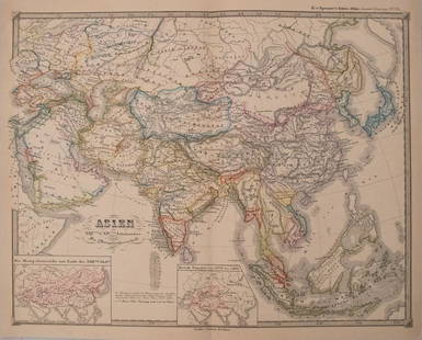
Sold2017Spruner: Antique Map of Asia, 1855Map: 1855 Spruner Map of Asia -- Asien im Xvten und XVIten Jahrhundrert… Cartographer: K v Spruner Year / Place: 1855 Dimensions: 12.8 x 16.5 in. Condition: Very Good to Excellent. On thick paper, sSee Sold Price
Sold2016ANTIQUE KOREAN GORYEO CELADON PORCELAIN BOWL, 13-14THNO RESERVE ON THIS LOT! ANTIQUE KOREAN GORYEO CELADON PORCELAIN DISH, 13-14TH CENTURY. 13 CM WIDE. PROVENANCE - NEW YORK NY ESTATESee Sold Price
Sold2015ANTIQUE KOREAN GORYEO CELADON PORCELAIN BOWL, 13-14THANTIQUE KOREAN GORYEO CELADON PORCELAIN DISH, 13-14TH CENTURY. 18 CM WIDE. PROVENANCE - NEW YORK NY ESTATESee Sold Price
Sold2016ANTIQUE KOREAN GORYEO CELADON PORCELAIN BOWL, 13-14THNO RESERVE ON THIS LOT! ANTIQUE KOREAN GORYEO CELADON PORCELAIN DISH, 13-14TH CENTURY. 11 CM WIDE. PROVENANCE - NEW YORK NY ESTATESee Sold Price
Sold202217C. Jodocus Hondius Map of Asia Colored EngravingAntique 17th century map of Asia by Jodocus Hondius (Belgian Dutch, 1563-1612). Colored engraving originally published in 1631. Displayed in a wooden frame. Work Size: 15 x 19.5 in.SHIPPINGHill AuctioSee Sold Price
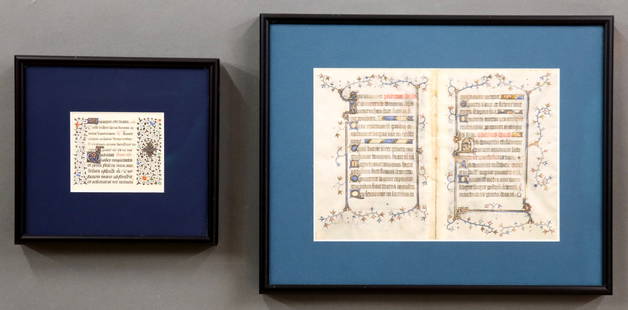
Sold20242 Illuminated Books of Hours ManuscriptsA 13/14th century Illuminated Manuscript bifolium and leaf on vellum from the "Book of Hours". Hand-written Latin text with polychrome tempera illuminations and Gilded detail. Single smaller leaf withSee Sold Price
Sold2017A Blue and White Porcelain VaseA Blue and White Porcelain Vase, 14th/15th Century, H 28cmSee Sold Price
Sold2016A Blue and White Porcelain VaseA Blue and White Porcelain Vase, 14th/15th Century, H 42cmSee Sold Price
Sold2016A Blue and White Porcelain VaseA Blue and White Porcelain Vase, 14th/15th Century, H 28cmSee Sold Price
Sold2016A Copper Red Meiping Dragon VaseA Copper Red Meiping Dragon Vase, 14th/15th Century, H 42cmSee Sold Price
Sold2019A Blue and White Porcelain VaseA Blue and White Porcelain Vase, 14th/15th Century, H 28cmSee Sold Price
Sold2018Mallet: Antique Map of Asia Minor with Black Sea, 1683Title of the Map: 'Natolie' Shows the Black sea & Cyprus. Asia Minor Turkey. Black Sea Cyprus Rhodes. Date Printed: 1683 Image Size: Approx Overall page size 13 x 21cm approximately (5 x 8 inches); imSee Sold Price
Sold2017Hughes: Antique Map of Asia Minor & Syria, 1856Map: Asia Minor and the Northern Part of Syria Date: 1856 By William Hughes from Long's Classical Atlas Size: 13 x 10 inches Please note that this lot has a confidential reserve. When you leave a bidSee Sold Price
Sold2018Levasseur: Antique Map of Asia, 1852Title/Content of Map: 1852 Levasseur Map of Asia -- Asie Date Printed: 1852, Paris Cartographer: V. Levasseur Size: 11 x 16.5 in. A highly decorative nineteenth century map of Asia, dominated by RussiSee Sold Price
Sold2017SDUK: Antique Map of Central Asia & Siberia, 1846Title/Content of Map: 'WESTERN SIBERIA, INDEPENDENT TARTARY, KHIVA, BOKHARA &c' Date Printed: 1846 Image Size: Approx 42.0 x 34.5cm, 16.5 x 13.75 inches (Large) Type: Antique steel engraved map with oSee Sold Price
Sold2017Bradford: Antique Map of Siberia & Central Asia, 1835Map: Siberia & Central Asia Date Printed: 1835 Cartographer: T.G. Bradford Material/Medium: Paper Size: 13" x 9 1/2" Condition: Very Good. Some foxing on edges. Does not affect Map. Hand colored outliSee Sold Price
Sold20231700s MAP of ASIA MINOR ARMENIA SYRIA SYCILY PERSIA antiqueMap of Asia Minor early 18th century hand colored Size 14 1/2 by 18 3/4" Very good condition Reserve: $160.00 Shipping: Domestic: Flat-rate of $25.00 to anywhere within the contiguous U.S. InternaSee Sold Price
Sold2023Exquisite Southeast Asian Bronze Buddha Head Statuette (13th-14th Century AD)This antique statuette, measuring 17x7x6cm (6.69x2.76x2.36 inches), is a testament to the rich spiritual cultures of Southeast Asia during the 13th to 14th century AD. Crafted from either bronze or brSee Sold Price
Sold2017Colton: Antique Map of Northern Italy, 1855Map: 1855 Colton Map of Northern Italy -- Northern Italy Date Printed: 1855 New York Cartographer: J Colton Size: 13 X 15.5 in. Condition: Very good. Colored. Slight marginal toning. A modest chip inSee Sold Price
Sold2018Colton: Antique Map of Southern Italy, 1855Title/Content of Map: 1855 Colton's Southern Italy -- Southern Italy Kingdom of Naples, I. Sardinia & Malta Date Printed: 1855, New York Cartographer: J Colton Size: 13 X 15.5 in. A very attractive maSee Sold Price
Sold2022Corea and Japan by John Thomson. East Asia. Korea 1830 old antique map chartTITLE/CONTENT OF MAP: 'Corea and Japan' DATE PRINTED: 1830 IMAGE SIZE: Approx 52.0 x 66.5cm, 20.5 x 26.25 inches (Large); Please note that this is a folding map. TYPE: Antique early 19th century atlasSee Sold Price
Sold201813 Maps of Canada mid 19th Century13 Maps of Canada mid 19th Century-- Dimensions: largest 26.5x 16 - smallest 12.25x15.25 inches.---See Sold Price
18 hrs LeftJasper52Johnson's Asia. Bod or Tibet. Toorkistan Cabool Birmah Persia Corea 1865 map$40(1 bid)
18 hrs LeftJasper52Johnson's Asia. Bod or Tibet. Toorkistan Cabool Birmah Persia Corea 1861 map$40(1 bid)
18 hrs LeftJasper52La Tartaria Indipendente… Central Asia, Caspian Sea & Caucasus. ZATTA 1785 map$100(1 bid)
18 hrs LeftJasper52NORTH & CENTRAL ASIA. Siberia Japan Korea Khiva Bukhara Turkistan 1901 old map$8(1 bid)
18 hrs LeftJasper52NORTH & CENTRAL ASIA. Siberia Japan Korea Khiva Bokhara Turkistan 1912 old map$10(1 bid)
18 hrs LeftJasper52EAST ASIA INDUSTRIES. China Korea East Indies Philippines. Manila plan 1920 map$50
18 hrs LeftJasper52CENTRAL ASIA. Aral Sea Turkestan Khiva Bukhara Samarkand. JOHNSTON 1913 map$55(1 bid)
18 hrs LeftJasper52SOUTH & SOUTH WEST ASIA. Physical. Main railways. BARTHOLOMEW 1952 old map$8(1 bid)
18 hrs LeftJasper52Asia c750AD Chin Machin Chen-la Tu-fan Caliphs Empire pilgrim routes 1935 map$30(1 bid)
Featured18 hrs LeftJasper52FRENCH INDOCHINA & DUTCH EAST INDIES Siam Burma Penang Manila Singapore 1912 map$20
18 hrs LeftJasper52BOKHARA KABUL & BALUCHISTAN. Afghanistan Khorassan Sinde Pakistan. SDUK 1846 map$30
18 hrs LeftJasper52BOKHARA KABUL & BALUCHISTAN. Afghanistan Khorassan Sinde Pakistan. SDUK 1851 map$40
18 hrs LeftJasper52SOUTH WEST ASIA. Persia Afghanistan Baluchistan.Pakistan.British India 1920 map$20(1 bid)