Sold2023PACIFIC OCEAN Sandwich Islands/Hawaii Australia New Zealand &c. WELLER 1863 mapTITLE/CONTENT OF MAP: 'The Pacific Ocean' DATE PRINTED: 1863 IMAGE SIZE: Approx 47.0 x 65.0cm, 18.5 x 25.75 inches (Large); Please note that this is a folding map. TYPE: Antique map with original outlSee Sold Price
Sold2017Weller: Map of Pacific, Hawaii Australia New ZealandTITLE/CONTENT OF MAP: 'The Pacific Ocean'. Sandwich Islands/Hawaii Australia New Zealand This map is folding hence the centrefold line may show on the image below DATE PRINTED: 1862 IMAGE SIZE: ApproxSee Sold Price
Sold2018PACIFIC OCEAN Sandwich Islands/Hawaii Australia NewReserve Reduced! TITLE/CONTENT OF MAP: 'The Pacific Ocean' DATE: 1863 IMAGE SIZE: Approx 47.0 x 65.0cm, 18.5 x 25.75 inches (Large); Please note that this is a folding map. TYPE: Antique map with origSee Sold Price
Sold2016Hawaiian & Pacific Polynesian Islands, Australia, 1850Original engraving by Samuel Augustus Mitchell from Mitchell’s Universal Atlas, 1850. Map highlights the Pacific ocean & surrounding islands; Hawaii, Polynesian, Australia & New Zealand. Dimensions:See Sold Price
Sold2023PACIFIC OCEAN. Australia New Zealand Polynesia Micronesia. BLACKIE 1893 mapTITLE/CONTENT OF MAP: 'The Pacific Ocean, general map' DATE PRINTED: 1893 IMAGE SIZE: Approx 35.0 x 51.5cm, 13.75 x 20.25 inches (Large); Please note that this is a folding map. TYPE: Colour Antique mSee Sold Price
Sold2018Pacific OceanTitle/Content of Map: Pacific Ocean Date Printed: 1840-05-15 Cartographer: WALKER, J. & C. Size: 12.2X15.5 Details from the Aleutian Island to Australia/New Zealand and to Cape Horn/South America. DetSee Sold Price
Sold2018Reclus, Elisee C1880 Lot of 28 Wood Eng Maps, GoodIncl Australia, Tasmania, New Zealand, Philippines, Reunion, Madeira, Madagascar, Indian & Pacific Ocean. Wood Engraved Maps with surrounding and verso text. Published 1875-94, Paris for "La NouvelleSee Sold Price
Sold2018Indian Ocean Map 1941Indian Ocean Map : Australia, New Zealand and Malaysia. National Geographic magazine. Date: 1941. Editor: Gilbert Grosvenor. Measurement approximate: 25 x 32. Shipping cost: $15.00 excluding Hawaii, ASee Sold Price
Sold2016Reinecke: Australia/ New Zealand/ Hawaii Map 1804Map: Australia/ New Zealand/ Hawaii/ South Pacific "General Charte von Australien" Publishing: Reinecke, Johann Matthias: Weimar Date: 1804 Size: 17.75 x 24 inches An uncommon map described by TooleySee Sold Price
Sold2017Brockhaus: Antique Map of South Pacific, 1885Title/Content of Map: 1885 Brockhaus Map of South Pacific including Hawaii, Australia and New Zealand -- Ocenaien und Australisches Festland Date Printed: 1885, Leipzig Cartographer: F Brockhaus Size:See Sold Price
Sold2019Johnston, W. & A. K. 1903 Lot of 28 MapsLot of 28 Lithograph Maps, incl Twin Hemisphere, Europe, Argentina, Canada, New Guinea, New Zealand, Australia, Pacific, Abyssinia, Egypt, Rhodesia, Central Africa, Algeria, Africa, Tibet, Japan, RussSee Sold Price
Sold2019Johnston, W. & A. K. 1903 Lot of 28 MapsLot of 28 Lithograph Maps, incl Twin Hemisphere, Europe, Argentina, Canada, New Guinea, New Zealand, Australia, Pacific, Abyssinia, Egypt, Rhodesia, Central Africa, Algeria, Africa, Tibet, Japan, RussSee Sold Price
Sold2021Australien und Polynesien (Australia & Polynesia)Title: Australien und Polynesien (Australia & Polynesia) Publisher: Haack Height: 62 Width: 82 Handsome and enormous display map of the South Pacific from All of Australia, New Zealand through most ofSee Sold Price
Sold2022Kelly, Christopher 1816 Map. Pacific Ocean. AustraliaCopper Engraved Map Published 1816, London for "A New and Complete System of Universal Geography" by Christopher Kelly. Maps Engraved by Findlay, Wallis and others. Paper Size: 10 x 8 inch (26 x 21cm)See Sold Price
Sold2018Pacific OceanReserve Reduced! Title/Content of Map: Pacific OceanDate: 1835 Cartographer: BRADFORD, THOMAS GAMALIEL Material/Medium: AMERICAN STATIONERS COMPANY Size: 7.75 x 10 inches Australia called New Holland.See Sold Price
Sold2018Weller, F. S. C1890 Lot of 12 Antique MapsIncl German Empire, Switzerland, Holland/Belgium, Austria/Hungria, Russia, Asia, Africa, Sweden/Norway & Denmark, France, Australasia, Eastern Australia and New Zealand, and The World. Lot of 12 LithoSee Sold Price
Sold2021[Pacific Islands] Oceanic Steamship Co. Playing Cards.[Pacific Islands] Oceanic Steamship Co. Playing Cards. San Francisco, ca. 1920. 52 + J + EC + OB. Joker advertises the ocean liner’s service to Hawaii, Samoa, Tahiti, New Zealand, Australia, andSee Sold Price
Sold2023POLYNESIA/PACIFIC ISLANDS. inc Sandwich/Hawaiian islands. RAPKIN/TALLIS 1851 mapCAPTION PRINTED BELOW PICTURE: 'Polynesia or Islands in the Pacific Ocean' Vignettes: Resolution Bay, Marquesas; Harbour of Dory, New Guinea; Otaheite [Tahiti]; Kalakakooa, Sandwich Islands [HawaiianSee Sold Price
Sold2018POLYNESIA/PACIFIC ISLANDS. inc Sandwich/HawaiianTITLE/CONTENT OF MAP: 'Polynesia or Islands in the Pacific Ocean' Vignettes: Resolution Bay, Marquesas; Harbour of Dory, New Guinea; Otaheite [Tahiti]; Kalakakooa, Sandwich Islands [Hawaiian islands].See Sold Price
2018POLYNESIA/PACIFIC ISLANDS. inc Sandwich/HawaiianReserve Reduced! TITLE/CONTENT OF MAP: 'Polynesia or Islands in the Pacific Ocean' Vignettes: Resolution Bay, Marquesas; Harbour of Dory, New Guinea; Otaheite [Tahiti]; Kalakakooa, Sandwich Islands [HSee Sold Price
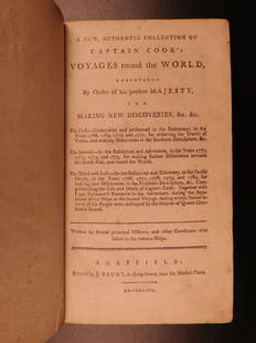
Sold20191786 VERY RARE Voyages of Captain James Cook Hawaii1786 VERY RARE Voyages of Captain James Cook Hawaii Pacific Australia New Zealand “Remember, the greater the opportunity, the fewer are those who see it.” – James Cook James Cook was an 18th-cenSee Sold Price
Sold20191855 Colton Map of Hawaii, New Zealand, Oceania IslandsTitle/Content of Map: 1855 Colton Map of Hawaii, New Zealand, Oceania Islands -- Hawaii or Sandwitch Islands [with] Samoan.. [with] New Zealand [with] Viti Group or Feejee Islands [with] Societi IslanSee Sold Price
Sold2019Nicolao Visscher. Orbis Terrum Nova MapNicolao Visscher (Dutch, 1618-1709). A hand-colored engraved map, circa 1658. Orbis Terrum Nova et Accuratussna Tabula. Showing partial coastlines of New Zealand and Australia. Unframed. 23-1/2 in x 2See Sold Price
Sold2024Large Lot of Sterling Silver Souvenir SpoonsLarge Lot of Mostly Sterling Silver Souvenir Spoons, 66 total spoons, including examples from Africa, the Middle East, Greece, Turkey, Philipines, Russia, Australia, New Zealand, Hong Kong, Vietnam, SSee Sold Price
May 11Trillium Antique Prints & Rare BooksPrevost - Map of the South Pacific Ocean with New Holland (Australia), New Zealand, and part of the$50
Jun 02Schilb Antiquarian Rare Books1880 Captain James Cook Voyages Hawaii Pacific Australia Kippis South Sea Navy$1
May 14Akiba Galleries(2 Pc) Allain Manesson Mallet Description De L'Univers 2 Vol. German Translation$200(1 bid)
6 days LeftRail & Road AuctionsThree New York Central Railroad Annual Passes - 1863, 1865, and 1869$40
May 14Fleischer's Auctions1755 Map Partie de l'Amerique Septentrionale, qui comprend Le Cours de L'Ohio...$200(3 bids)
2 days LeftCoral Gables AuctionErnest William Christmas (1863 - 1918) Australia - Palace Painting$100
7 days LeftRail & Road AuctionsSeven Panama Pacific Line Steamship Travel Guides, Timetable, and Menu - 1927 to 1939$30
6 days LeftHunt and Peck Estate Services, Inc.1784 Captain James Cook "A Voyage to the Pacific Ocean" 2 of 3 volumes$360(2 bids)
May 11Crescent City Auction GalleryWilliam H. Williams (1817-1886), New Orleans "Map of the Sixth District and Carrollton," 1871, H.-$650
2 days LeftTremont AuctionsJohn Speed and Francis Lamb "Map of New England and New York", ca. 1676. Hand colored engraved map$900(3 bids)


![[Pacific Islands] Oceanic Steamship Co. Playing Cards.: [Pacific Islands] Oceanic Steamship Co. Playing Cards. San Francisco, ca. 1920. 52 + J + EC + OB. Joker advertises the ocean liner’s service to Hawaii, Samoa, Tahiti, New Zealand, Australia, and](https://p1.liveauctioneers.com/928/188932/95239653_1_x.jpg?height=310&quality=70&version=1609352044)
![POLYNESIA/PACIFIC ISLANDS. inc Sandwich/Hawaiian islands. RAPKIN/TALLIS 1851 map: CAPTION PRINTED BELOW PICTURE: 'Polynesia or Islands in the Pacific Ocean' Vignettes: Resolution Bay, Marquesas; Harbour of Dory, New Guinea; Otaheite [Tahiti]; Kalakakooa, Sandwich Islands [Hawaiian](https://p1.liveauctioneers.com/5584/298779/159029476_1_x.jpg?height=310&quality=70&version=1692132475)
![POLYNESIA/PACIFIC ISLANDS. inc Sandwich/Hawaiian: TITLE/CONTENT OF MAP: 'Polynesia or Islands in the Pacific Ocean' Vignettes: Resolution Bay, Marquesas; Harbour of Dory, New Guinea; Otaheite [Tahiti]; Kalakakooa, Sandwich Islands [Hawaiian islands].](https://p1.liveauctioneers.com/5584/128489/65352606_1_x.jpg?height=310&quality=70&version=1538523113)
![POLYNESIA/PACIFIC ISLANDS. inc Sandwich/Hawaiian: Reserve Reduced! TITLE/CONTENT OF MAP: 'Polynesia or Islands in the Pacific Ocean' Vignettes: Resolution Bay, Marquesas; Harbour of Dory, New Guinea; Otaheite [Tahiti]; Kalakakooa, Sandwich Islands [H](https://p1.liveauctioneers.com/5584/129679/65959649_1_x.jpg?height=310&quality=70&version=1540338370)
![1855 Colton Map of Hawaii, New Zealand, Oceania Islands: Title/Content of Map: 1855 Colton Map of Hawaii, New Zealand, Oceania Islands -- Hawaii or Sandwitch Islands [with] Samoan.. [with] New Zealand [with] Viti Group or Feejee Islands [with] Societi Islan](https://p1.liveauctioneers.com/5584/157856/79675033_1_x.jpg?height=310&quality=70&version=1577197209)