Sold20231851 American Navigator MAPS Bowditch Voyage Sailing Illustrated Navigation1851 American Navigator MAPS Bowditch Voyage Sailing Illustrated Navigation Nathaniel Bowditch shipped out in 1795 on the first of five voyages to the East Indies. He spent his time pouring over the sSee Sold Price
Sold20201859 American Navigator Bowditch Voyage Sailing1859 American Navigator Bowditch Voyage Sailing Illustrated MAPS Navigation Nathaniel Bowditch shipped out in 1795 on the first of five voyages to the East Indies. He spent his time pouring over the sSee Sold Price
Sold20201833 Davenport Gazetteer of N. America w/foldout mapsA New Gazetteer or Geographical Dictionary of North America and the West Indies, etc. Original full calf. Gilt-decorated spine with label. Illustrated with two fully hand-colored, foldout maps and manSee Sold Price
Sold20241839 Map of North America with the Republic of Texas. By MoninTitle: 1839 Map of North America with the Republic of Texas. By Monin Date/Period: 1839 Materials: Hand colored, engraved Size: 17 1/2 x 12 1/2" This map is a stunning representation of North AmericaSee Sold Price
Sold20211839 MAP OF ULSTER COUNTY, NEW YORK, BY DAVID H. BURR,1839 MAP OF ULSTER COUNTY, NEW YORK, BY DAVID H. BURR, STONE & CLARK PUBLISHERS, ITHICA, N.Y. NICELY FRAMED, FROM PROMINENT ELLENVILLE, N.Y. ATTORNEYS OFFICE. MAP MEASURES 22" X 23", NICELY FRAMED, ANSee Sold Price
Sold20201839 Maps, Middle States, Burgess, MitchellTwo hand colored maps, both dated 1839: "Map of the Middle States and part of the Southern, Engraved to Illustrate Mitchells School and family Geography" by S. Augustus Mitchell, engraved by J. H. YouSee Sold Price
Sold20241839. Map of Australia and Pacific by MoninTitle: 1839. Map of Australia and Pacific by Monin Date/Period: 1839 Materials: Hand colored, engraved Size: 17 1/2 x 12 1/2" This is a map of Australia and the Pacific in 1839 when the continent wasSee Sold Price
Sold20211839 Map of the Southern States, SmithHandsome map drawn and engraved by Stiles, Sherman & Smith to accompany Smith’s Geography for Schools. Shows the entire deep south except for the lower half of Florida. Shows the navigable distanceSee Sold Price
Sold20241839 Map of Norway and Sweden with insert of Iceland by MoninTitle: 1839 Map of Norway and Sweden with insert of Iceland by Monin Date/Period: 1839 Materials: Hand colored, engraved Size: 17 1/2” x 12 1/2” 1839. By V. Monin. Paris. Hand-colored, engSee Sold Price
Sold2020Grp: 6 Maps of SpainGroup of six maps of France and Spain. Includes Friedrich Wilhelm Streit (1772-1839) map of France "Charte von Frankreich nach den besten Hulfsmitteln," Nuremberg, 1815; Guillaume Delisle (1675-1726)See Sold Price
Sold2024NAUTICAL COLLECTIONA SEAMAN'S DISCOVERY LOT INCLUDING LOG, NAVIGATIONAL PROTRACTOR, RITCHIE COMPASS, VAN NOSTRANDS NAUTICAL MANUALS, BOWDITCH'S NAVIGATOR.See Sold Price
Sold2016MATHEW CAREY (AMERICAN, 1760-1839) MAP OF DELAWAREMATHEW CAREY (AMERICAN, 1760-1839) MAP OF DELAWARE, hand-colored engraving on paper, titled "Delaware from the best Authorities", engraved by William Barker, published Philadelphia, 1795. Modern frameSee Sold Price
Sold20181839 Mitchell Map of the United StatesTitle/Content of Map: 1839 Mitchell Map of the United States -- No. 5 Map of the United States Date Printed: 1839, Philadelphia Cartographer: S Mitchell Size: 10.2 x 16.7 in. This early US map has terSee Sold Price
Sold2021VINTAGE BOWDITCH NAUTICAL MAP OF SALEM 30"VINTAGE BOWDITCH " CHART OF THE HARBORS OF SALEM MARBLEHEAD BEVERLY AND MANCHESTER COLLECTIBLE MARITIME NAUTICAL MAP CARTOGRAPHY MASS MASSACHUSETTS-25" X 30" APPROX TO FRAME-VERY GOOD CONDITION, WEARSee Sold Price
Sold20201839 Tanner Map of Florida -- FloridaTitle/Content of Map: 1839 Tanner Map of Florida -- Florida Date: 1839, Philadelphia Cartographer: H Tanner Size: 14.2 X 11.2 in This is an attractive map of Florida. There are references to forts, baSee Sold Price
Sold20201839 Tanner Map of Georgia -- A New Map of Georgia withTitle/Content of Map: 1839 Tanner Map of Georgia -- A New Map of Georgia with its Roads & Distances Cartographer: H Tanner Year/Place: 1839, Philadelphia Size: 13.8 X 11.2 in. This is a handsome map oSee Sold Price
Sold20181839 Mitchell Map of Africa -- No. 25 Map of AfricaTitle/Content of Map: 1839 Mitchell Map of Africa -- No. 25 Map of Africa Date: 1839, Philadelphia Cartographer: S Mitchell Size: 8.1 x 10.1 in. A quite nice map of Africa, showing that much of the inSee Sold Price
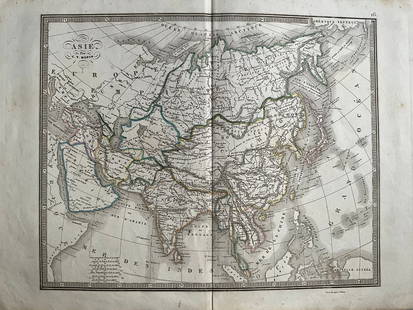
20241839 Asia Map by MoninTitle: 1839 Asia Map by Monin Date/Period: 1839 Materials: Hand colored, engraved Size: 17 1/2 x 12 1/2" This map is an interesting depiction of Asia in 1839 when the continent was still largely unexpSee Sold Price
Sold20241839 Italy Map by MoninTitle: 1839 Italy Map by Monin Date/Period: 1839 Materials: Hand colored, engraved Size: 17 1/2” x 12 1/2” 1839. By V. Monin. Paris. Hand-colored, engraved. Good condition, with some foxinSee Sold Price
Sold20221762 Brookes The General Gazetteer MapsTitle: 1762 Brookes The General Gazetteer Maps Description: "The General Gazetteer: or, Compendious Geographical Dictionary. Containing a description of all the empires, Kingdoms, States, RepublicsSee Sold Price
Sold2023Early Wall Map of Dutchess Putnam New York, David Burr 1839Early Wall Map of Dutchessand Putnam County New York, David Burr 1839. Antique map in scroll format with thick dark painted wood supports features cities of the period including Poughkeepsie, RhinebecSee Sold Price
Sold2016Early Map of The Michigan Territory by CareyThe Upper Territories of the United States, 1814. Matthew Carey (1760-1839). Engraved map with original hand color in outline. Philadelphia, 1814. 22 x 17 1/4 inches sheet. The map reflects a very earSee Sold Price
Sold2019United States from The Latest AuthoritiesTitle: United States from The Latest Authorities Date: 1853 Cartographer: HAYWARD'S GAZATTEER Publisher: HAYWARD'S GAZETTEER Size: 21.5Height - 39.5Width HAYWARD'S GAZATTEER HAYWARD'S GAZETTEER Map onSee Sold Price
Sold2017Burgess: Antique Map of Africa, 1839Title/Content of Map: 1839 Burgess Map of Africa -- Map of Africa Date Printed: 1839, New York Cartographer: D Burgess / Smith Pub. Size: 10.6 x 8.7 in. An excellent and very interesting map of AfricaSee Sold Price
Jun 07Freeman's | HindmanMURCHISON, Roderick Impey, Sir. The Silurian System. 1839. COMPLETE WITH VERY RARE HAND-COLORED$1,500
6 days LeftJasper52NIGERIA w/ early explorers' routes. Lake Chad Yariba Houssa Borgou.SDUK 1844 map$60
Jun 23Treasure Quest AuctionsPr. Child's Ulster County, NY 1871-72 Gazetteer & Business Directories$50
1 day LeftTrillium Antique Prints & Rare BooksWilkes - 6 View Engravings of New Zealand, Tonga, Fiji, &c.$100
1 day LeftTrillium Antique Prints & Rare BooksWilkes - 13 Native People Engravings (Portrait of Commanders including Wilkes, people from New$100


![[Lockhart, John Gibson], (1 of 7)](https://p1.liveauctioneers.com/1782/331487/178781730_1_x.jpg?height=282&quality=70&version=1716992745)


