Sold2018Thomson: Antique Map of Canada & Nova Scotia, 1817Title/Content of Map: Canada and Nova Scotia. Date Printed: 1817 Cartographer: THOMSON, JOHN & CO. Size (inches): 16.1x22 No.43 (unnumbered) from Thomson's New General Atlas 1817. W. Dassauville engr.See Sold Price
Sold20221850s map of British North America, W & R ChambersEngraved map titled “Principal British Possessions in North America.” Nova Scotia, New Brunswick, Lower Canada and Upper Canada are marked in original outline hand color. Above this stretcSee Sold Price
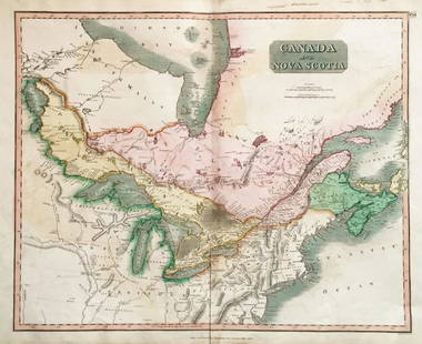
Sold2018Thomson: Upper & Lower Canada, Nova ScotiaMap: Canada and Nova Scotia Cartographer: Thomson Place/Date: Edinburgh / 1814/1817 Size: 23 3/4" x 19 1/8" Condition: wash color; light browning along centerfold and in margins; some staining in uppeSee Sold Price
Sold20241794 Laurie & Whittle after Thomas Jefferys Map Of The United States Of AmericaWITH THE BRITISH POSSESSIONS OF CANADA, NOVA SCOTIA, NEW BRUNSWICK, AND NEWFOUNDLAND divided with the French, also The Spanish Territories Of Louisiana and Florida according to the Premliminary ArticlSee Sold Price
Sold2022(UNITED STATES.) Laurie & Whittle; after Thomas Jefferys. The United States of America(UNITED STATES.) Laurie & Whittle; after Thomas Jefferys. The United States of America with the British Possessions of Canada, Nova Scotia, New Brunswick and Newfoundland Divided with the French, alsoSee Sold Price
Sold2018Thomson: Antique Map of Canada & Nova Scotia, 1814Map: Canada and Nova Scotia Cartographer: Thomson Place & Date: Edinburgh / 1814/1817 Size: 23 3/4" x 19 1/8" Condition: wash color; light browning and minor staining in margins The superbly detailedSee Sold Price
Sold2021MICHAUX/NUTTALL - North American Sylva, 5 volumes 1871MICHAUX, François-André (1770-1855) and Thomas NUTTALL (1786-1859). The North American Sylva; or, a description of the forest trees of the United States, Canada, and Nova Scotia. Philadelphia: W.M.See Sold Price
Sold2023RARE (3) volume set ( The North American Sylva, or a description of the forest trees of the UnitedRARE (3) volume set ( The North American Sylva, or a description of the forest trees of the United States, Canada and Nova Scotia, Considered particularly with respect to their use in the Arts, and thSee Sold Price
Sold20211819 North American Sylva F Andrew Michaux 2 Vols1819 The North American Sylva a Description of the Forest Trees of the United States, Canada, and Nova Scotia. Includes volumes one and two by F Andrew Michaux. Published by C D'Hautel Paris. IllustraSee Sold Price
Sold2024The North American Sylva[Botany] Michaux, Francois-Andre; Nuttall, Thomas. The North American Sylva; or, A Description of the Forest Trees of the United States, Canada, and Nova Scotia. Philadelphia: D. Rice & A.N. Hart, 185See Sold Price
Sold20221897 Signed William McKinley Appointment1897 signed William McKinley Presidential appointment of John G Foster of Derby, VT as Consul General of the United States to Canada, Halifax, Nova Scotia, sold with the corresponding Canadian documenSee Sold Price
Sold2024Map of Nova Scotia & Newfoundland by John Tallis, 1851DescriptionTitle/Content of Map: Map of Nova Scotia & Newfoundland by John Tallis, 1851Date Printed: 1851Cartographer: John TallisMaterial/Medium: EngravingSize: 11 x 14"John Tallis was a British mapSee Sold Price
Sold2020New Map of That Portion of North America 1851New Map of That Portion of North America Exhibiting the United States and Territories, the Canadas, New Brunswick, Nova Scotia and Mexico also Central America and the West India Islands, 1851, Jacob MSee Sold Price
Sold2020New Map of That Portion of North America 1854New Map of That Portion of North America Exhibiting the United States and Territories, the Canadas, New Brunswick, Nova Scotia and Mexico also Central America and the West India Islands, 1854, Jacob MSee Sold Price
Sold2020140 Pcs World Currency Incl Coins and NotesIncludes 39 Europe and Great Britain with 1808 Napoleon franc, 1795 Portual 20 reis, 1754 Portual 10 reis; 12 North and South America with five Buffalo nickels; 80 Canada with 1832 Nova Scotia 1/2 penSee Sold Price
Sold2017Vintage Paper W Canvas Map of USAroom Sized Vintage Paper W Canvas Map of USA. Reads as the 'New Map of That Portion of North America, Exhibiting the United States &Territories, The Canadas, New Brunswick, Nova Scotia, and Mexico, alSee Sold Price
Sold2023America. North/South Americas. British Florida. Missions. THOMSON 1817 mapTitle: "America". North/South Americas. British Florida. Missions. THOMSON 1817 map Description: America' by Drawn & engraved by John & George Menzies for John Thomson's "New General Atlas" (PublishedSee Sold Price
Sold2023MAP, Canada, CruttwellEastern Canada. Clement Cruttwell, British America, Comprehending Canada, Labrador, New-Foundland, Nova Scotia &c:, from Atlas to Cruttwell's Gazetteer, 1808 (dated). Hand Color. This scarce map of CaSee Sold Price
Sold2023The Coast of New England, Nova Scotia, New France or Canada. GENTS MAG 1746 mapTITLE/CONTENT OF MAP: 'A New Chart of the Coast of New England, Nova Scotia, New France or Canada with the Islands of Newfoundl.d, Cape Breton St. John's &c. Done from the Original Publish'd in 1744 aSee Sold Price
Sold20241746 Large Engraved Map New England Nova ScotiaA New Chart of the Coast of New England, Nova Scotia, New France or Canada with the Islands of NewFoundl(an)d, Cape Breton, St. John and C.. by Nicolas Bellin, English version printed for Gentleman'sSee Sold Price
Sold2017Bellin/Jefferys: Antique Map of Canada & Islands, 1746Map: A new chart of the coast of New England, Nova Scotia, New France or Canada, with the islands of Newfoundl’d. Cape Breton, St. John’s &c. Publication Date: 1746 Authors: Gentleman’s MagazineSee Sold Price
Sold2021Bellin, Jacques 1746 Map of Canada & New England"A New Chart of the Coast of New England, Nova Scotia, New France or Canada, with the islands of Newfoundld. Cape Breton St. John's &c" by Jacques-Nicolas Bellin. Copper Engraved Map Published LondonSee Sold Price
Sold2019NOVA SCOTIA.& New Brunswick Quebec Prince Edward'sTITLE/CONTENT OF MAP: 'NORTH AMERICA, SHEET I., NOVA SCOTIA WITH PART OF NEW BRUNSWICK AND LOWER CANADA' The top image on the right hand side shows the entire map. To view a close up of the map showinSee Sold Price
Sold2023John Lovell's "History of Canada" - 1866 Antique BookJohn Lovell's "History of Canada", 1866. This book goes into great detail about the British provinces in North America. This book is in very good condition. 7" x 4 1/2" x 1"See Sold Price
Jun 07Freeman's | HindmanMICHAUX, François André and Thomas NUTTALL. The North American Sylva...1852-1853. Later$1,000
5 days LeftAlbion AuctionsBlackie (Pub) 1882 Folio Map. Canada - Quebec, Nova Scotia, New Brunswick, Prince Edward$5
5 days LeftAlbion AuctionsClarke & Russell 1814 Hand Col Map. Canada - British Dominions in North America$25(3 bids)
Jun 15Bazaar of Persia2 letters from Canada 1 Local Toronto o 1 f Pictou NS (Nova Scotia) t USA 18th century$50


![The North American Sylva: [Botany] Michaux, Francois-Andre; Nuttall, Thomas. The North American Sylva; or, A Description of the Forest Trees of the United States, Canada, and Nova Scotia. Philadelphia: D. Rice & A.N. Hart, 185](https://p1.liveauctioneers.com/179/322586/173446597_1_x.jpg?height=310&quality=70&version=1710365197)


