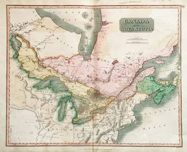
Sold2018Thomson: Antique Map of Canada & Nova Scotia, 1814Map: Canada and Nova Scotia Cartographer: Thomson Place & Date: Edinburgh / 1814/1817 Size: 23 3/4" x 19 1/8" Condition: wash color; light browning and minor staining in margins The superbly detailedSee Sold Price
Sold2018Thomson: Antique Map of Canada & Nova Scotia, 1817Title/Content of Map: Canada and Nova Scotia. Date Printed: 1817 Cartographer: THOMSON, JOHN & CO. Size (inches): 16.1x22 No.43 (unnumbered) from Thomson's New General Atlas 1817. W. Dassauville engr.See Sold Price
Sold2018Thomson: Upper & Lower Canada, Nova ScotiaMap: Canada and Nova Scotia Cartographer: Thomson Place/Date: Edinburgh / 1814/1817 Size: 23 3/4" x 19 1/8" Condition: wash color; light browning along centerfold and in margins; some staining in uppeSee Sold Price
Sold2017Bellin: Antique Map of Canada Arcadia Nova Scotia, 1740Title/Content of Map: Canada. Arcadia. Or Nova Scotia Date Printed: c 1740-70's Cartographer: J.N. Bellin & J.F. La Harpe Material/Medium: Paper Size: 10" x 15" Copperplate engraved. Published in PariSee Sold Price
Sold2022Three Antique Engraved Maps of Canada: From the London Magazine, 1749, Nova Scotia Drawn FromThree Antique Engraved Maps of Canada: From the London Magazine, 1749, Nova Scotia Drawn From Surveys by T. Kitching; Canada ou Nouvelles France, 1683 by A. Mallet, Paris; and Amerique SeptentrionaleHSee Sold Price
Sold2017Bellin/Jefferys: Antique Map of Canada & Islands, 1746Map: A new chart of the coast of New England, Nova Scotia, New France or Canada, with the islands of Newfoundl’d. Cape Breton, St. John’s &c. Publication Date: 1746 Authors: Gentleman’s MagazineSee Sold Price
Sold2019Lower Canada, New Brunswick, Nova Scotia' Quebec &TITLE/CONTENT OF MAP: 'Lower Canada, New Brunswick, Nova Scotia &c.; Inset map of Newfoundland' DATE PRINTED: 1862 IMAGE SIZE: Approx 31.0 x 45.0cm, 12.25 x 17.75 inches (Large) TYPE: Antique map withSee Sold Price
Sold2017Colton: Antique Map of New Brunswick, Nova Scotia, 1861Title/Content of Map: Canada, New Brunswick, Nova Scotia and Newfoundland Date Printed: 1861 Cartographer: J.H. Colton Material/Medium: Paper Size: 17 1/4" x 13" Hand colored steel engraved Map from 'See Sold Price
Sold2017Bellin: Antique Map of St. Lawrence Gulf; Canada, 1745Partie orientale de la Nouvelle France ou Canada'. St Lawrence. The map shows the Gulf of St Lawrence including what are now the maritime provinces of Canada (Nova Scotia, New Brunswick, Newfoundland,See Sold Price
Sold2022Antique Map - Map of North America - Canada - Toronto - Montreal - William HugheAn interesting mid 19th century map of Upper and Lower Canada - with an inset of New Brunswick and Nova Scotia - which appeared in Barclay's Universal English Dictionary (London: George Virtue, 1840s)See Sold Price
Sold2018Tallis / Rapkin: Antique Map Nova Scotia & NewfoundlandTitle/Content of Map: 'Nova Scotia and Newfoundland' Vignettes: Halifax, Nova Scotia; Cod Fishery off Newfoundland. Halifax view. Canada. PE. Date Printed: 1851 Image Size: Approx 36.5 x 26.5cm, 14.5See Sold Price
Sold2017Johnson: Set of 2 Antique Maps of Ontario/New FoundLandTitle/Content of Map: Canada set of 2 Maps Ontario/New Found-Land Nova Scotia Date Printed: 1868 Cartographer: A.J. Johnson Material/Medium: Paper Size: 24 1/2" x 18" Hand colored steel engraved Map.See Sold Price
Sold2017Mitchell: Antique Map of Nova Scotia, New BrunswickTitle/Content of Map: County Map of Nova Scotia, New Brunswick, Cape Breton and Prince Edward Date Printed: 1869 Cartographer: Augustus S. Mitchell Material/Medium: Paper Size: 12" x 15 1/4" ConditionSee Sold Price
Sold2017Thomson: Antique Map of British India, 1814Map: British India Southern Part/British India Northern Part Cartographer: Thomson Place & Date: Edinburgh / 1814/1817 Size: 24 1/8" x 22 5/8" Condition: overall age-toning and spotting; repaired spliSee Sold Price
Sold2017Thomson: Antique Map of North America, 1814Map: North America Cartographer: Thomson Place & Date: Edinburgh / 1814/1817 Size: 23 5/8" x 19 1/2" Condition: outline color; overall age toning with some browning along centerfold and minor spottingSee Sold Price
Sold2018Thomson: Antique Map of Asiatic Turkey, 1814The magnificent Middle East map from Thomson's New General Atlas encompasses in great detail the Turkish empire's Asian territories from the Aegean to its borders with Persia and Russia. Cartographer:See Sold Price
Sold2017Thomson: Antique World Map, Mercator's Projection, 1814Map: Chart of the World on Mercator's Projection Cartographer: Thomson Place & Date: Edinburgh / 1814 Size: 20" x 17 3/4" Condition: b&w; overall age toning; browning along centerfold; two small, repaSee Sold Price
Sold2023Map of Canada’s New Brunswick, Nova Scotia, Newfoundland by ColtonTitle: Map of Canada’s New Brunswick, Nova Scotia, Newfoundland by ColtonDate/Period: 1859Materials: Hand colored steering engravedSize: 17 1/2 x 14 1/2”Newfoundland, New Brunswick, Nova ScotiSee Sold Price
Sold2017Map of Canada, Eastern Section, Nova Scotia, 1885Map of Canada, Eastern Section. New Brunswick, Nova Scotia. A. & C. Black's Atlas. 1885. 18 x 23 inches No Reserve: This lot starts at $1 and has no reserve as a courtesy so that collectors can determSee Sold Price
Sold2018Colton: Antique Map of New Brunswick & Nova ScotiaTitle/Content of Map: New Brunswick & Nova Scotia by Colton Date Printed: 1859 Cartographer: H.J. Colton Material/Medium: Paper Size: 17 1/2" x 15" Hand colored, engraved Map. Published in New York inSee Sold Price
Sold2017Cram: Map of Canada New Brunswick & Nova Scotia, 1891Map: Dominion of Canada verso New Brunswick & Nova Scotia Date: 1891 From Cram's "Unrivaled Family Atlas of the World Indexed" TWO Maps, one on each side Size: 14.5 x 11 inches Please note that this lSee Sold Price
Sold2017Thomson: Antique Map of New Holland (Australia), 1814Map: New Holland and Asiatic Islands Cartographer: Thomson Place & Date: Edinburgh / 1814/1817 Size: 24 1/4" x 19 3/4" Condition: overprinting and some staining; repaired splits along centerfold and nSee Sold Price
Sold2018Thomson: Antique Map of The Venetian States, 1814Title/Content of Map: The Venetian States Cartographer: Thomson Place & Date: Edinburgh / 1814/1817 Size: 19 1/4" x 23 1/4" Condition: light overprinting; minor spotting; some browning along the centeSee Sold Price
Sold20191855 Colton Map of Eastern Canada -- New Brunswick,Title/Content of Map: 1855 Colton Map of Eastern Canada -- New Brunswick, Nova Scotia, Newfoundland, and Prince Edward Id. Date: 1855, New York Cartographer: J Colton Size: 11.8 X 15.2 in. This is a vSee Sold Price
May 09Hunt and Peck Estate Services, Inc.1794 Laurie & Whittle after Thomas Jefferys Map Of The United States Of America$340(1 bid)
4 days LeftTrillium Antique Prints & Rare BooksCarey, pub. 1814 - Map of Hindostan or India$50(1 bid)
4 days LeftTrillium Antique Prints & Rare BooksCarey, pub. 1814 - Map of the East Indies with India, China, & New Holland (Australia)$50(1 bid)
4 days LeftTrillium Antique Prints & Rare BooksCarey, pub. 1814 - Map of New South Wales, Australia$50
2 days LeftJasper52Islands in the Pacific Ocean. Hawaii. Phantom Jardines islands. THOMSON 1830 map$75
12 hrs LeftJasper521816 VOYAGE TO ABYSSINIA by HENRY SALT w/ MAP antique 1st AMERICAN EDITION rare$400