Sold2017Anderson - Virginia from the Best AuthoritiesJohn Payne (active 1800), The State of Virginia from the best Authorities 1799, John Low (1763-1809) publisher, Alexander Anderson (1775-1870) engraver, black and white line engraving, 7-3/8 x 10 inSee Sold Price
Sold2023First American Revolutionary War Battle Map, from Nathan Daboll, Freebetter's New-England Almanacks,American Revolution First American Printing of a Revolutionary War Battle Map Titled: "A VIEW of the Present Seat of War, at and near New-York." by Nathaniel Low, Printed by John Gill, Boston 1777-DatSee Sold Price
Sold2021After John Speed. Map of GermanyAfter John Speed (English, 1552-1629). A hand-colored engraved map titled "A New Mape of Ye XVII Provinces of Low Germanie". Dated 1626. Framed under glass. Mat opening: 16in x 21in. Provenance: FromSee Sold Price
Sold20181610 Map of Nottingham by Cartographer John SpeedHistoric Maps 1610 Map "The Countie of Nottingham described..." by Cartographer John Speed & Engraved by Jodocus Hondius 1610-Dated, Hand-Colored English Map titled: "The Countie of Nottingham describSee Sold Price
Sold20231754 An Accurate Map Of the English Colonies in North America1754 An Accurate Map Of the English Colonies in North America bordering on the River Ohio, by John Hinton. Covers the Carolinas to the Great Lakes and Casco Bay off the coast of present-day Maine. PubSee Sold Price
Sold2022Richard John English Polo Players Oil PaintingRichard John (English/American: B. 1910) mid century oil painting on canvas depicting polo players on horseback titled "The Match". Hand signed to lower right. Measures: 36-1/4" W x 24" H. Frame: 44-1See Sold Price
Sold20221796 John Reid American Map of the West Indies - by John Reid. AN ACCURATE MAP OF THE WEST INDIES1796 John Reid American Map of the West Indies - by John Reid. AN ACCURATE MAP OF THE WEST INDIES WITH THE ADJACENT COAST OF AMERICA. Engraved by D. Martin. Published in New York in "An American AtlasSee Sold Price
Sold2021Wilkes, John 1809 Hand Col Map. HollandHand Colored Copper Engraved Map Published 1796-1828 London for "Encyclopaedia Londinensis, or universal dictionary of arts, sciences and literature" by John Wilkes et al. Paper Size: 10.5 x 8.5 inchSee Sold Price
Sold2018JOHN REID (AMERICAN, 18TH/19TH CENTURY) MAP OF VIRGINIAJOHN REID (AMERICAN, 18TH/19TH CENTURY) MAP OF VIRGINIA, on laid paper, title in oval cartouche to upper left corner "the STATE of / VIRGINIA / from the best Authorities / 1796", above "Published by JSee Sold Price
Sold2015Map of American English or United States. 1830.Victor Lavasseur. Map of American English or United States. 1830.Print of hand colored steel engraving titled Amerique Anglaise“.Author Victor Lavasseur.Engraved by unknown.From Atlas classique univSee Sold Price
Sold2018JOHN CARY (ENGLISH 1754-1835), ENGRAVED MAPS, THEJOHN CARY (ENGLISH 1754-1835), ENGRAVED MAPS, THE RUSSIAN EMPIRE, LONDON, 1811. SIGHT 18 1/2 X 40"; FRAMED AND GLAZED-21 X 42" (2/JOINED SHEETS)See Sold Price
Sold2022John Senex Map of Louisiana & Mississippi River 1721John Senex (English, 1678-1740). "Map of Louisiana and the River Mississippi," from "A New General Atlas," London, 1721. Dedicated to William Law of Lanreston. This map is an EngliSee Sold Price
Sold2024(5pc) JOHN HENRY RAMBERG (1763-1840)Five works including: John Heinrich Ramberg (German/English, 1763-1840), watercolor, Garden scene, signed and dated 1788 lower left (5 x 3-1/4 in.); John Raphael Smith (England, 1752-1812) pencil drawSee Sold Price
Sold2022Map of Europe - Italy - Corsica - Austria - Norway - Spain - Poland - John LodgeTitle: Map of Europe - Italy - Corsica - Austria - Norway - Spain - Poland - John Lodge Description: A fine 1778 map of Europe by the English map publisher John Lodge. Date/Period: 1778 Materials: PapSee Sold Price
Sold2023LOW FLAME STITCH UPHOLSTERED FOOTSTOOLAmerican or English low footstool, 19th/20th century, having flame stitch upholstery, metal nailhead trim, and rising on wooden bun feet, apparently unmarked. Approximate dimensions: h. 7", sq. 15.75"See Sold Price
Sold2022Antique Map of Europe - Map of Switzerland - Geneva - Luzern - John LodgeA fine 1778 map of Switzerland by the English map publisher John Lodge. Technique: Hand colored steel engraving. Date: ca 1778. Artist: John Lodge. Place: London, England. Size: 10” x 8” iSee Sold Price
Sold2016JOHN SENEX, (English, 1678-1740), A New Map of Italy,JOHN SENEX (English, 1678-1740) A New Map of Italy, 1708 Engraving with later hand-coloring (two sheets) Corrected from the Observations Communicated to ye Royal Society at London and ye Royal AcademySee Sold Price
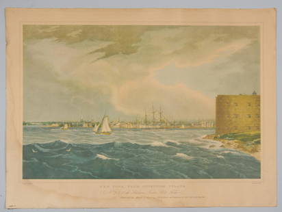
Sold2022After W. G. Wall, New York from Governors Islandc1940 Haggard & Co. reproduction of the c.1823 color aquatint by English-born American John Hill (1770–1850,) after a painting by Irish born artist William Guy Wall (1792-after 1864.) Caption rSee Sold Price
Sold2022Novel A Single Pebble, John Hersey, 2nd print.A Single Pebble by John Hersey. English novel about an American in the 1920s sent to China for an engineering project along the Yangtze River. 2nd print, c 1956. Alfred A. Knopf, Inc. 8,5 x 5.5 in. 3See Sold Price
Sold2022JOHN TALLIS (1817-1876) AN AMERICAN CIVIL WAR MAP, "United States," LONDON, CIRCA 1863,JOHN TALLIS (1817-1876) AN AMERICAN CIVIL WAR MAP, "United States," LONDON, CIRCA 1863, hand-colored lithograph on wove paper showing, "Federal, Non Slave Holding States (Red); Border, Slaveholding (BSee Sold Price
2019Early English road map by John OgilbyHeading: (Maps) Author: Ogilby, John Title: The Road from London to St. Neotts in Com. Hunt. Continued to Oakeham in Com Rutland Place Published: London Publisher: Date Published: 1675See Sold Price
Sold2018Morden: Antique Map of Florida & the Great Lakes, 16931693 map of Florida and the Great Lakes by Robert Morden. 5 x 5 inches. A very special map--one of the very earliest obtainable English maps of the American colonies. A Map of Florida and Ye Great LakSee Sold Price
Sold2021"A New Map of North America" by John Cary, 1806John Cary (English, 1754-1835). An engraved map with hand coloring by famed cartographer John Cary, whose maps of North America documented the wide ranging unknown, especially surrounding the MidwestSee Sold Price
Sold2024John Swatsley (B. 1937) Steamboat Phoenix (1809)John Swatsley (American, B. 1937) "Steamboat Phoenix (1809)" Signed lower right. Original Oil painting on Illustration Board. Provenance: Collection of James A. Helzer (1946-2008), Founder of UnicoverSee Sold Price
4 days LeftJasper521878 INVENTION of PRINTING by T. de VINNE ILLUSTRATED antique SIGNED by AUTHOR!$160
4 days LeftJasper52Mid 18th Century Antique George II Sterling Silver Pint Mug London 1742 John Eckford$1,900
4 days LeftJasper5219th Century George III Antique Sterling Silver Oval Tray London 1793 Thomas Hannam & John Crouch II$5,500
4 days LeftJasper52Early 18th Century Antique George II Large Sterling Silver Brandy Pan London 1729 John Edwards II$1,400
4 days LeftJasper5219th Century Antique Victorian Sterling Silver Sugar Caster London 1898 John Bodman Carrington$340
4 days LeftJasper5219th Century Antique Victorian Sterling Silver Pair Roll Dishes London 1885 John Brashier$1,400
4 days LeftJasper5218th Century Antique Pair of George IIII Sterling Silver Salvers London 1782 John Crouch I & Thomas$2,800
Featured4 days LeftJasper52PUIFORCAT (HERMES) & HENIN FRERES 195pcs LOUIS XVI STERLING SILVER FLATWARE SET 1850-1899$18,000
Featured4 days LeftJasper52TWO CANDELABRA, FRENCH ANTIQUE GOLD PLATED BRONZE, MUSEUM QUALITY !!$6,500
May 12Schilb Antiquarian Rare Books1844 Siege of Gibraltar American Revolution SPAIN France Drinkwater MAP History$1(1 bid)
Jun 02Schilb Antiquarian Rare Books1864 Puritan John Winthrop 1ed Life of Colonial America Massachusetts Bay Colony$1