Sold2018JOHN REID (AMERICAN, 18TH/19TH CENTURY) MAP OF VIRGINIAJOHN REID (AMERICAN, 18TH/19TH CENTURY) MAP OF VIRGINIA, on laid paper, title in oval cartouche to upper left corner "the STATE of / VIRGINIA / from the best Authorities / 1796", above "Published by JSee Sold Price
Sold2017Early Map of Georgia, John Payne, Circa 1810John Payne (American, 18th/19th century), "Georgia from the latest Authorities 1810"-1810/11. An early American engraved map of the Southern United States by mapmaker John Payne (American, 18th/19th cSee Sold Price
Sold20221796 John Reid American Map of the West Indies - by John Reid. AN ACCURATE MAP OF THE WEST INDIES1796 John Reid American Map of the West Indies - by John Reid. AN ACCURATE MAP OF THE WEST INDIES WITH THE ADJACENT COAST OF AMERICA. Engraved by D. Martin. Published in New York in "An American AtlasSee Sold Price
Sold2024GROUP OF PRINTS, MAPS AND SAMPLERS.American and European, 18th-19th century. Printed maps of Ohio, small booklet with wool on linen sampler examples, chromolithographs of insects, and several hand colored botanical prints published bySee Sold Price
Sold2023Group of American 18th/19th century autographs(1) John Bayard, 1703-1807, US Patriot, manuscript deed, (2) Henry Ward Beecher 1880 letter, (3) Henry Cabot Lodge TLS, (4) Abraham Van Vechten, 1762-1848, American lawyer, 1833 letter, (5) David KirkSee Sold Price
Sold2022Map of "The State of Massachusetts from the Best Information 1796"Map of "The State of Massachusetts from the Best Information 1796," hand colored copper engraving, published by J. Reid, New York from John Reid's American Atlas the second folio-sized atlas publishedSee Sold Price
Sold2021American School 18th/19th century Portrait of PatrickAmerican School 18th/19th century Portrait of Patrick Henry (1736-1799) Oil on canvas, framed. (12 1/2 in. x 10 in. (sight)) Provenance Deaccessioned by the Virginia Museum of History & CultuSee Sold Price
Sold2015JOHN ARCHER (AMERICAN, 19TH CENTURY), AFTER WILLIAMJOHN ARCHER (AMERICAN, 19TH CENTURY), AFTER WILLIAM GOODACRE (AMERICAN, 19TH CENTURY) PRINT OF THE CAPITOL RICHMOND, VIRGINIA, hand-colored engraving affixed to glass, view from the southwest, possiblSee Sold Price
Sold2022Three 18th Century North Carolina Mapsengravings on laid paper, all unframed, including: John Reid, The State of North Carolina From the Best Authorities, engraver Benjamin Tanner, New York, circa 1796, sheet 16-1/2 x 19 in.; Matthew CareSee Sold Price
Sold2024A group of Latin American religious sculpturesA group of Latin American religious sculptures18th/19th centuryThe carved wood figures comprising a gilt and polychrome Mary figure holding baby Jesus, a crucifix housed in a small tabernacle with plaSee Sold Price
Sold202319th century. A hand-colored American Civil War era map of Virginia, Delaware, Maryland, and West19th century. A hand-colored American Civil War era map of Virginia, Delaware, Maryland, and West Virginia. Published by A.J. Johnson New York USA. Marked as page 47. Overall good condition; some browSee Sold Price
Sold2024Two Latin American carved wood puttiTwo Latin American carved wood putti18th/19th centuryEach carved, polychromed, and giltwood child figure swathed in fabric with clasped hands in prayer, mounted to a carved giltwood base with scrolledSee Sold Price
Sold2016A Map of the Tennassee Government, formerly part ofJohn Reid & W. Winterbotham. from the American Atlas. New York: J. Reid, L. Wayland & C. Smith, 1796. 2 Engraved Map Joined as Issued. 19 x 16 1/4 inchesSee Sold Price
Sold2016The State of New Hampshire...John Reid & W. Winterbotham. from the American Atlas. New York: J. Reid, L. Wayland & C. Smith, 1796. Engraved Map with Orignal Hand-color in Outline. 16 1/4 x 19 1/4 inchesSee Sold Price
Sold2016(lot of 2) Meso-American carved wood Santos figures,(lot of 2) Meso-American carved wood Santos figures, 18th/19th century, each polychrome decorated with gilt accents, depicting John the Baptist together with The Mother of God and baby Jesus, largest:See Sold Price
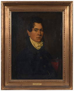
Sold2023Important Virginia Portrait(American School, 19th Century) John Mason McCarty (1795-1852), not visibly signed, oil on canvas, 26 x 20 in.; gilt wood frame, 33-1/2 x 27-1/4 in. Provenance: Descended in the family of the consignoSee Sold Price
Sold2018Antique John Smith Atlantic Region Map Virginia OrigState 10: Page 41, numbers changed to 1690 and 1691. A true piece of American history, not a reproduction!Fine example of John Smith's map of the newly formed Virginia colony, one of the true milestonSee Sold Price
Sold2016EARLY MAP OF CONNECTICUT BY JOHN REIDFROM THE BEST AUTHORITIES"; ENGRAVED FOR THE AMERICAN EDITION OF WINTERBOTHAM'S HISTORY OF AMERICA, PUBLISHED BY JOHN REID, NEW YORK (2 SMALL BLEACH SPOTS LOWER LEFT & RIGHT); 14 1/2" X 17 1/2See Sold Price
Sold20211855 1ed Napoleon Bonaparte WARS French Revolution1855 1ed Napoleon Bonaparte WARS French Revolution Illustrated Maps 2v Abbott John S.C. Abbott was a 19th-century American historian who wrote works on a variety of topics including the French RevolutSee Sold Price
Sold2017Antique Map: John Smith's Map of VirginiaFramed antique map. John Smith's Map of Virginia. Well-engraved early 19th century reproduction. Discovered and Described by Captain John Smith, 1606. First published in 1612, this was one of the mostSee Sold Price
Sold2019Homanianos Heredes (18th Century) South American.Homanianos Heredes (18th Century) South American. "Tabula Americae Specialis Geographica Regni Peru, Brasilae Terrae Firmae et Reg. Amazonum", Map, 19" x 21.75".See Sold Price
Sold2023An American metalwares mid 19th century soup ladle and four tablespoons,An American metalwares mid 19th century soup ladle and four tablespoons, mark of John Bishop, Wheeling, West Virginia, circa 1850, 'Fiddle' pattern, monogrammed, 12.8ozt gross (5)See Sold Price
Sold20231881 Western Wilds Native American INDIANS Custer Mormonism Brigham Young MAP1881 Western Wilds Native American INDIANS Custer Mormonism Brigham Young MAP John Beadles “Western Wilds” is a rare 19th-century account of voyages in the American west, primarily throughSee Sold Price
Sold2017John H. Tyler Sterling Punch Ladle, Richmond, VAAn American sterling silver punch or soup ladle. Late 19th century. The back of handle marked Sterling, John H. Tyler & Co. (Richmond, Virginia) and with a maker's cipher. Stylized 3-initial monogramSee Sold Price
3 days LeftTremont Auctions17th century original map 1676 "Virginia and Maryland" by John Speed. 2 sided framing. Overall:$325(2 bids)
May 09Hunt and Peck Estate Services, Inc.ANTONIO ZATTA (ITALIAN, 18TH CENTURY) MAP OF VIRGINIA$80(2 bids)
May 09Hunt and Peck Estate Services, Inc.ANTONIO ZATTA (ITALIAN, 18TH CENTURY) MAP OF VIRGINIA$70(1 bid)
4 hrs LeftLeland LittleJohn Harvey (American 20th/21st Century), American Craft Curly Maple Dining Table$125(2 bids)
May 12Neo FineArts IncTwo Sculptural Wooden Objects By John Sauer(20/21st Century, American Artist)$30(1 bid)


![[Gettysburg] Pickett's Charge Survivor (1 of 2)](https://p1.liveauctioneers.com/7226/325455/175169130_1_x.jpg?height=282&quality=70&version=1712370394)


![Assorted (12) Books [Non-Fiction] (1 of 4)](https://p1.liveauctioneers.com/5755/327684/176532732_1_x.jpg?height=282&quality=70&version=1714078974)