Sold20191748 Bellin World Map -- Essay d'une Carte Reduite,Reserve Reduced! Title/Content of Map: 1748 Bellin World Map -- Essay d'une Carte Reduite, Contenant les Parties Connuees du Globe Terrestre Date: 1748, Paris Cartographer: J Bellin Size: 19.6 X 27.4See Sold Price
Sold2022Large Antique French 1748 D'anville Map of South America in a set of 3Jean-Baptiste Bourguignon d’Anville (1697-1782) was one of the foremost French geographers of the eighteenth century. He carried out rigorous research in order to create his maps, which greatlySee Sold Price
Sold2023Antique French J. Forest World Map GlobeDESCRIPTION: Antique terrestrial globe world map, drawn up by the geographer J.Forest, from 17-19 rue de Buci in Paris. Scale 1/50.000.000. With a solid wooden block base and interior light. Joseph FoSee Sold Price
Sold2023Antique Carte Pour L' Intelligence Du Livre Institute L' Esprit De S Loix Old World Framed MapAntique French framed old world map with gold tone frame. Professionally framed. Measures 15 1/2" x 24" total with 9" x 18" matte.See Sold Price
Sold2020Nicolas Bellin circa 1750 antique mapFuzhou aka Fu Cheu Fu  panorama view by cartographer Jacques Nicolas Bellin. Antique map Circa 1750. 10"x 14". Jacques Nicolas Bellin was a French hydrographer, geographer, and member of theSee Sold Price
Sold2020Nicolas Bellin Circa 1750 antique mapPanoramic view of "Ruins De Sempalat" Siberia by cartographer Jacques Nicolas Bellin. Antique Map Circa 1750.  10" x 14" Jacques Nicolas Bellin was a French hydrographer, geographer, and memberSee Sold Price
Sold2018Bellin / la Harpe: Antique Map of the World, 1740Title/Content of Map: Rare large world Map Date Printed: 1740-1770's Cartographer: J.N. Bellin & J.F. La Harpe Material/Medium: Paper Size: 21 1/4" x 28" Copperplate engraved. From the 'Abrege de L'HiSee Sold Price
Sold2017Bellin: Antique Map of Chinese Empire, 1748Map: L'Empire de la Chine Cartographer: Bellin Place & Date: Paris / 1748/1760 Size: 15 5/8" x 11 1/4" Condition: outline color; old folds; overall age toning; a light water stain in the right marginSee Sold Price
Sold2017Antique French Map and Plan of Boston, MassachusettsTitle/Content of Map: Antique French Map and Plan of Boston, Massachusetts Date Printed: 1757 Cartographer: Bellin, Jacques Nicolas Size (in): 10 x 6 One of the earliest obtainable town plans of BostoSee Sold Price
Sold2024French Map of the Mid-Atlantic CoastAntique French Map of the Mid-Atlantic Coast, "Carte de la Virginie, de la Baye Chesapeak, et Pays Voisins", by Jacques Bellin, Paris, c. 1761, with later hand-coloring, sight 8 in. x 12 in., framedSee Sold Price
Sold2017Bellin: Antique Map of Madera & Porto Santo, 1748Map: Karte von den Eylanden Madera und Porto Santo Cartographer: Bellin Place & Date: Leipzig / 1748 Size: 8 5/8" x 6 1/8" Condition: old color; overall age toning and some staining and spotting, mostSee Sold Price
Sold2018Bellin: Antique Map of Cape Verde Islands, 1748Title/Content of Map: Karte von den Eylanden des Grunen Vorgeburges Cartographer: Bellin Place & Date: Leipzig / 1748 Size: 11" x 8 1/4" Condition: old color; overall age toning and some staining andSee Sold Price
Sold20171799 Antique Geographical Dictionary Fold Out World Map1799 Antique Geographical Dictionary In French With Fold Out Map Of The World. Volume 1. Printed In Bruxelles. Good Condition, Some Foxing, Some Wear Of The Binding. Size 8 By 5" Please note that thisSee Sold Price
Sold2018* BELLIN, Jacques Nicholas (1703-1772). Essay d'une* BELLIN, Jacques Nicholas (1703-1772). Essay d'une Carte Reduite, Contenant les Parties Connuees du Globe Terrestre. Paris, 1748. Engraved map of the world on Mercator's projection, image 500 x 700 mSee Sold Price
Sold2022Globe Form Ceramic Vase And JarLot 106 Globe Form Ceramic Vase And Jar an Italian Zaccagnini vase and a French Porcelaine de Paris covered jar, both decorated with an antique style map of the world, marked to bases 12 1/2 x 11 3/4See Sold Price
Sold2022Globe Form Ceramic Vase And JarLot 229 Globe Form Ceramic Vase And Jar an Italian Zaccagnini vase and a French Porcelaine de Paris covered jar, both decorated with an antique style map of the world, marked to bases 12 1/2 x 11 3/4See Sold Price
Sold2023Two Maps, Africa by Eustache Herisson, 1809, World Hemispheres 1832 Reprint after A.H Brue, GermanDescription: An antique Africa map, in French and dated 1809 by Eustache Herisson, and a reprit of an early 19th century map of World Hemispheres by Adrien-Hubert Brue. Type: MapMaterials: PaperMarkinSee Sold Price
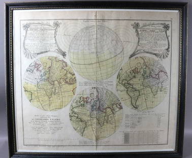
Sold20231747 Leonhard Euler Map of the World with Earth Eclipse & SolarFramed November 1747 Leonhard Euler Map of the World with earth and lunar eclipse including calculated degrees of the eclipse arriving 1748. This would be an important and timely prediction of a majorSee Sold Price
Sold2023Four Antique Maps, China & Asia, Gerard Mercator, Jacques BellinDescription: To include a 1628 map of China and Asia by from the Gerard Mercator Atlas Minor (framed), a 1748 copper engraved Jacques Bellin map of Cathay (Northern China & Southern Mongolia), a 1749See Sold Price
Sold2019French Carved Walnut World Globe Bar, 20th c., withFrench Carved Walnut World Globe Bar, 20th c., with antique map decoration, the interior with a fitted revolving tray, on turned legs to a quadruped base, H.- 35 in., Dia.- 21 in.See Sold Price
Sold2017Terrestrial and celestial globesTitle/Content of Map: Terrestrial and celestial globes Date Printed: 1760 Cartographer: Le Rouge, George Size (in): 11 x 9 Antique old French copper-plate engraving ca. 1748 of two globes: a terrestriSee Sold Price
Sold20201660 BarbariaThis is an authentic antique map of the northern coast of Africa by Joan Blaeu. The map was published out of Amsterdam circa 1660, and features French text on the verso. This lovely, decorative map foSee Sold Price
Sold2023MAP, China & Korea, BellinChina & Korea. Jacques Nicolas Bellin, L'Empire de la Chine pour Servir a l'Histoire Generale des Voyages, from Histoire Generale des Voyages, 1748 (dated). Hand Color. Attractive and detailed map ofSee Sold Price
Sold20201757 Carte du Kamtchatka Dressee et Gravee par LaurentThis is an authentic antique map of the Kamchatka Peninsula. The map was engraved by J. Laurent and published by Jacques Bellin out of Paris in 1757. This striking map of the Kamchatka peninsula displSee Sold Price
1 day LeftTrillium Antique Prints & Rare BooksBonne - Map of the Eastern Coast of North America$85(3 bids)
Featured5 days LeftJasper521771 ASTRONOMY by Joseph M. de La Lande 2 VOLUMES ILLUSTRATED antique in FRENCH$480
1 day LeftTrillium Antique Prints & Rare BooksBraun & Hogenberg, pub. 1575 - View of Cairo, Egypt$100
1 day LeftTrillium Antique Prints & Rare BooksBraun & Hogenberg, pub. 1575 - View of Stockholm, Sweden$100
1 day LeftTrillium Antique Prints & Rare BooksBraun & Hogenberg, pub. 1575 - View of Brussels, Belgium$100
1 day LeftTrillium Antique Prints & Rare BooksBraun & Hogenberg, pub. 1575 - View of Canterbury, England$100
1 day LeftTrillium Antique Prints & Rare BooksBraun & Hogenberg, pub. 1575 - View of Utrecht, Netherlands$100
1 day LeftTrillium Antique Prints & Rare BooksBraun & Hogenberg, pub. 1575 - View of Zurich, Switzerland$100
5 days LeftJasper52c1720 World showing Dutch East India Co possessions. CA as a island. By J.Malherbe$650
May 09Hunt and Peck Estate Services, Inc.Jacques Nicolas Bellin Map Of Western Part Of New France Or Canada$200(1 bid)
6 days LeftJasper52Carte de l'Isle de Bourbon, autrefois Mascareigne'. Réunion. BELLIN 1750 map$70(1 bid)
Featured6 days LeftJasper52PACIFIC OCEAN currents British French German US Spanish colonies. LETTS 1889 map$15
1 day LeftTrillium Antique Prints & Rare BooksPtolemy & Magini, pub. 1620 - Map of France / Verso: Map of Germany$50
6 days LeftJasper52South Pacific Ocean. French Polynesia Cook Islands. US Navy sea chart 1895 map$130
6 days LeftJasper52PACIFIC OCEAN showing British French Dutch US territory. US Philippines 1947 map$20