Sold2023General chart of the coast No. VI from Cape Hatteras to Cape RomainPublication Date: 1882 Title: General chart of the coast No. VI from Cape Hatteras to Cape Romain Cartographer: Publisher: U.S. Coast and Geodetic Survey Height: 29 Width: 38 From a Trigonometric survSee Sold Price
Sold2022MOLL, HERMAN. A General Chart of the Sea Coast of Europe, Africa & America. According to E. Wright'sMOLL, HERMAN. A General Chart of the Sea Coast of Europe, Africa & America. According to E. Wright's or Mercator's Projection. Hand-colored engraved map of the Atlantic Ocean and continents adjacent.See Sold Price
Sold2020United States, East Coast – Forida Street BritishUnused, very detailed sea chart of the Florida coasts with Miami, Cape Kennedy, the Bahama Banks and so on. The first surveys are from 1898 from Admiralty surveys. Authentic, very detailed sea chart,See Sold Price
Sold2021Sketch F. Showing the Progress of the Survey in SectionPublication Date: 1856 Title: Sketch F. Showing the Progress of the Survey in Section VI With a General Reconnoissance of The Coast Of Florida 1848-56 Cartographer: BACHE, A.D. Publisher: U.S. COAST SSee Sold Price
Sold2023General Chart Map of Alaska (1890)General chart map of Alaska compiled and drawn by Adolph and Henry Lindenkohl, a coast and geodetic survey report for 1890 including Eastern Siberia, Russia, and the Aleutian Islands, dated 1890; unfrSee Sold Price
Sold2024A general chart of the West India Islands… DELAROCHETTE/FADEN Caribbean 1796 mapTitle: A general chart of the West India Islands… DELAROCHETTE/FADEN Caribbean 1796 map Description: A general chart of the West India Islands with the adjacent coasts of the Spanish continent by L.See Sold Price
Sold2016Ringgold chart of entrace to S.F. Bay 1850Heading: Author: Ringgold, Cadwalader Title: General Chart Embracing Surveys of the Farallones Entrance to the Bay of San Francisco and San Pablo Straits of Carquines and Suisun Bay and the SacramentSee Sold Price
Sold2024West Indies Caribbean Florida Bahamas Cuba ADMIRALTY chart 1876 (1949) old mapTITLE/CONTENT OF MAP: 'West Indian Islands and Caribbean Sea - Sheet I - Comprising Florida Strait, Bahama Islands and the Greater Antilles' DATE PRINTED: Surveyed to 1948. Published 1876. New editionSee Sold Price
Sold2018Scarce Sea Chart with every building, fort andHarrison, A. M. & Dorr, F. W. et al. Coast Chart No. 59, St. Augustine Inlet to Halifax River Florida. Lithographed map. U.S. Coast and Geodetic Survey, c. 1885. 41 ¼" x 31 ⅛" sheet. Great dSee Sold Price
Sold2023ANTIQUE FLORIDA FRAMED MAPS - LOT OF 2148268 ANTIQUE FLORIDA FRAMED MAPS - LOT OF 2 Antique Florida map framed map to include one 1853 U.S. Coast Survey Chart or Map of St. George's Sound, Florida, and one unsigned map of Florida denotedSee Sold Price
Sold20151833 J W Norie “New Chart of the Coast of America1833 J W Norie “New Chart of the Coast of America from New York & Philadelphia to the Strait or gulf of Florida†J Stephenson, engraver (rough as found condition, tears & creases, losses, maSee Sold Price
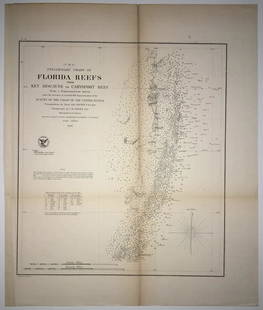
Sold2020(F No.4) Preliminary Chart of Florida Reefs from KeyTitle/Content of Map: (F No.4) Preliminary Chart of Florida Reefs from Key Biscayne to Carysfort Reef... Publication Date: 1855 Cartographer: Totten, Jas./I. Hull Adams Publisher: U.S. Coast Survey DeSee Sold Price
Sold2019U S Coast Survey 1896 LG Map. New Orleans Texas Florida"Sketch of General Progress June 30. 1896" Showing Southern, Eastern and Mid West States, incl Florida, Texas, Gulf of Mexico, Georgia etc. Large Lithograph Map Published 1896, Washington for "U.S. CoSee Sold Price
Sold2023U S Coast Survey 1856 Large Map. St. Mary's Bar & Fernandina Harbor Florida"Preliminary Chart of St. Mary's Bar and Fernandina Harbor Florida"Large Lithograph Map Published 1857, Washington for "U.S. Coast and Geodetic Survey" Folds as issued. Paper Size: 25 x 23 inch (64 xSee Sold Price
Sold2022A Delicate Blue And White Figure War General Chart Brush PotA Delicate Blue And White Figure War General Chart Brush Pot From Qing DynastySize: 21.5cmx20.2cmSee Sold Price
Sold2023World: Captain Cook, Large Folio - A General Chart Exhibiting the Discoveries made by Captain JamesThis fascinating folio engraving is from Captain James Cook & James King's A Voyage to the Pacific Ocean, for making Discoveries in the Northern Hemisphere. To determine the Position and Extent of theSee Sold Price
Sold2022Very Rare Vintage Halloween Novelty Box Made in USAProvenance from a deceased Halloween and Black Cat collector in West Coast, Florida. The box dimensions are Approx. 7" x 8.5" x 1.25" (small variances can occur). ABOUT SHIPPING: This lot is located iSee Sold Price
Sold2018World chart with discoveries of James Cook 1787Heading: Author: Faden, William Title: A New General Chart of the World, Exhibiting the Whole of the Discoveries made by the late Captain James Cook, F.R.S. with the Tracks of the Ships under his ComSee Sold Price
Sold2022Scarce Early Tin Mr. Thomas 5c Cigar Tip TrayProvenance from a deceased Halloween and Black Cat collector in West Coast, Florida. Scarce, early tin litho tip tray for Thomas brand 5 cent Cigars, features wonderful detailed image of trademark blaSee Sold Price
Sold2022LARGE MAP TRACKING SHIPPING ROUTE BETWEEN ENGLAND AND CHINA 24” x 37.5” sight. FramedLARGE MAP TRACKING SHIPPING ROUTE BETWEEN ENGLAND AND CHINA“A General Chart, on Mercator’s Projection, to shew the Track of the Lion and Hindustan from England to the Gulph of Pekin in ChiSee Sold Price
Sold2024James Kerr b.1953 Beach Day Florida Coast PaintingJames P. Kerr (American, born 1953). An oil painting on canvas. Titled, "Beach Day." An impressionist style work depicting sunbathers on the beach with the crashing waves of the ocean and a flock of sSee Sold Price
Sold2024CHART "SOUTHERN COAST OF LONG ISLAND FROM MONTAUK POINT TO EAST HAMPTON" Circa 1877 11.25" x 22.75"CHART "SOUTHERN COAST OF LONG ISLAND FROM MONTAUK POINT TO EAST HAMPTON"Circa 187711.25" x 22.75" sight. Framed 16.75" x 28". Provenance:An Important Connecticut Collection.See Sold Price
Sold2023MAYBELLE STAMPER OIL ON MASONITE PAINTINGMaybelle Stamper oil on masonite painting depicting the Florida coast. Signed and dated lower edge "Maybelle Stamper 1957". Measures (frame) 18" x 15.25" wide, and (sight) 12.5" x 10" wide. Condition:See Sold Price
Sold2023BEN AUSTRIAN LONE PALM PAINTING FLORIDA 1916AUSTRIAN, Ben, (American, 1870-1921): ''Lone Palm, Florida Coast, Beach, 1916'', Gouache/Paper, 8.75'' x 6.75'', signed lower left and dated 1916, original carved and painted frame, 10.75'' x 8.75''.See Sold Price
Jun 29JM Hobby Supply and Railroad Artifact AuctionsFlorida East Coast RY Rococo Pattern Dinner Plate$30(2 bids)
Jun 29JM Hobby Supply and Railroad Artifact AuctionsPair of EMD/General Motors Railroad Diesel Locomotive Posters$20
Jun 27Rail & Road AuctionsMixed Group of Southeastern Railroad Items - Switch Key, Locks, Lantern Globe, Timetables, and More$30
Jun 28Rail & Road AuctionsEleven Railroad China Butter Pats - Fred Harvey, John H. Murphy, Seaboard Air Line, Florida East$40
Jun 11Bill Hood & Sons Art & Antique AuctionsGuro Heddle Pulley, Ivory Coast, Africa - Wood. A pulley used for weaving with the traditional$200
1 day LeftJasper52Track Chart of Cruise of U.S. Rev. Steamer "Bear" and Overland Expedition to the Relief Of Whalers$60
Jun 11Bill Hood & Sons Art & Antique AuctionsBen Neill (AMERICAN, 1914) oil on canvas, sailboats of the coast, signed lower right, 18" x 24"$200(1 bid)
Jun 28Rail & Road AuctionsLouisville and Nashville Railroad Paper Group - Track Chart, Magazine, Mailing Envelopes, and More$20


![Across America, Rusling, 1875 [181941] (1 of 9)](https://p1.liveauctioneers.com/2699/331494/178785461_1_x.jpg?height=282&quality=70&version=1717189774)

