Sold2023Antique Illustrated 1876 Combination Saratoga Springs and Ballston Spa Atlas J.B. Beers PublisherAntique 1876 illustrated atlas of Saratoga Springs and Ballston Spa, New York. Includes United States Hotel, Congress Park, Morrissey Clubhouse, Broadway and more. Engravings of homes and buildings ofSee Sold Price
Sold2023Antique Illustrated 1876 Combination Saratoga Springs and Ballston Spa Atlas J.B. Beers PublisherAntique 1876 illustrated atlas of Saratoga Springs and Ballston Spa, New York. Includes United States Hotel, Congress Park, Morrissey Clubhouse, Broadway and more. Engravings of homes and buildings ofSee Sold Price
Sold20231876 Atlas of Illinois- Cook County Map Framed PagTravel back in time to the late 19th century with this enchanting Framed Map Page from the 1876 Atlas of Illinois by Warner & Beers. This exquisite piece showcases the detailed cartography of Cook, DuSee Sold Price
Sold2021Scarce twp. Map of Kans, Col. & Neb. - 1876Hand-colored, detailed township map of Kansas, Colorado & Nebraska from the very scarce Jones and Hamilton Historical Atlas of the World Illustrated. Atlas published 1876 by Higgins, Bro. & Co. An unuSee Sold Price
Sold20161876 New Centennial Atlas of Bucks County PA ScottDESCRIPTION: New Centennial Atlas of Bucks County, Pennsylvania by J.D. Scott. Philadelphia, 1876. Illustrated throughout with color maps and black-and white plates. Bound in half leather over dark brSee Sold Price
Sold20241876 Antique Atlas of York County, PA (2)Two York County, Pennsylvania atlases, the first copy complete with "Atlas of York Co. Pennsylvania Illustrated from Actual Surveys" dated 1876 by and under the direction of Beach Nichols and publisheSee Sold Price
Sold2019Scarce 1876 twp. map of Great LakesUnusual and very scarce hand colored map from the scarce Jones & Hamilton Historical Atlas of the World Illustrated. Published in 1876 by H. H. Hardesty, this “Special Map” delineates every townshSee Sold Price
Sold2021Centennial Atlas of Bucks County, Pennsylvania, 1876"New Centennial Atlas of Bucks County, Pennsylvania Illustrated Compiled, Drawn, and Published from Personal Examinations and Surveys", by J.D. Scott, Philadelphia 1876, printed by Thomas HuntSee Sold Price
Sold2021HISTORICAL ATLAS OF DUTCHESS COUNTY NEW YORKHISTORICAL ATLAS OF DUTCHESS COUNTY NEW YORK ILLUSTRATED - READING PUBLISHING HOUSE 1876. IN GOOD ESTATE CONDITION, FROM HOUSE IN STANFORDVILLE, N.Y. BEAUTIFUL MAPS AND ILLUSTRATIONS. HARD ATLAS TO FISee Sold Price
Sold20231873 Illustrated Encyclopedia and Atlas Map of Madison County IllinoisBinding, cover and back worn and pages mixed condition. Includes Saline, Venice and Greenwood to name a few areas. Measures 18 x 15 x 2 inches.See Sold Price
Sold2017Jones & Hamilton Antique Map of New Mexico, 1876From the scarce 1876 Jones & Hamilton Historical Atlas of the World Illustrated comes an early color map of New Mexico, possibly by Keith Johnston. Very detailed in both topographical features and infSee Sold Price
Sold2022Topographical Atlas of Bergen County NJ (US) 1876Topographical Illustrated, Historical Descriptive, A.H. Walker, Published by C.C. Pease, Successor to A.H. Walker. Color maps, home sites, business locations in fold-out pages. Cover in green with blaSee Sold Price
Sold20211876 RR map - NE U.S. in uncommon formatLarge and uncommon map of the upper eastern seaboard of the United States in an unusual layout. From the very scarce 1876 Jones and Hamilton Historical Atlas of the World Illustrated. Clean and soundSee Sold Price
Sold2021Atlas entitled "NEW ILLUSTRATED ATLAS OF DUTCHESSAtlas entitled "NEW ILLUSTRATED ATLAS OF DUTCHESS COUNTY NEW YORK" by O.W. Gray & Son - Reading Publishing House, Reading Pa. 1876. Book is complete with supplements and some maps with hand tinting. MSee Sold Price
Sold2021Scarce 1876 map of Florida with unusual layoutTitle: Scarce 1876 map of Florida with unusual layout Description: From the very scarce Jones & Hamilton Historical Atlas of the World Illustrated comes this unusual map of Florida. The only other exaSee Sold Price
Sold20211876 N. & S. Carolina by A. K. JohnstonThis unique map of North and South Carolina, by A. K. Johnston, was created in 1876 for the very scarce Jones and Hamilton “Historical Atlas of the World Illustrated." Johnstons maps represent aSee Sold Price
Sold20231810s ANCIENT & MODERN ATLAS illustrated w/ 62 MAPS antique volume 6 CyclopaediaVOLUME VI - PLATES The Cyclopaedia; or Universal Dictionary of Arts, Sciences, and Literature ANCIENT & MODERN ATLAS, contains 62 double page MAPS Philadelphia, Samuel F. Bradford and Murray, FairmanSee Sold Price
Sold2020[ATLASES]. Tackabury Atlas 1876Tackabury Atlas of the Dominion of Canada. Montreal, Toronto and London: George N. Tackabury, 1876.Large Folio. Half black leather. Shelf wear, chipped edges.See Sold Price
Sold20191843 Geography WORLD VIEWS Atlas Illustrated Jerusalem1843 Geography WORLD VIEWS Atlas Illustrated Jerusalem Israel India 6v Malte-Brun Conrad Malte-Brun was a French geographer and cartographer known for his impressive journal-like atlases and geographySee Sold Price
Sold20171807 William Guthrie French ATLAS Illustrated MAPS1807 William Guthrie French ATLAS Illustrated MAPS Asia Africa France America Originally translated into French in 1801, William Guthrie’s “Geographical, Historical and Commercial Grammar’, hasSee Sold Price
Sold2021[ATLAS] WALLING, H.F. TACKABURY’S ATLAS, 1876[ATLAS]. Walling, H.F. TACKABURY’S ATLAS OF THE DOMINION OF CANADA. Montreal: George Tackabury, 1876.272 pp. 130 coloured maps. Folio, 1/4 black leather with green cloth, gilt lettered, rebackeSee Sold Price
Sold2022Jules Verne, Five Weeks in a Balloon, 1876 illustrated"Five Weeks in a Balloon. A Voyage of Exploration and Discovery in Central Africa". From the French of Jules Verne. Author's Illustrated Edition with 26 woodcut illustrations by Riou + frontispiece anSee Sold Price
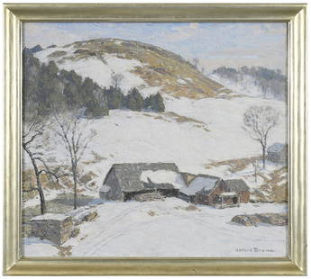
Sold2018Horace Brown(Vermont/Illinois, 1876-1949) Windswept Fields, signed lower right "Horace Brown", oil on canvas, 24 x 27 in.; gilt wood frame, 27-1/2 x 30-1/2 in.See Sold Price
Sold2019Ralph F. Seymour Signed Etching [Marine Scene, CA]Ralph Fletcher Seymour (Illinois 1876 - 1966) signed etching. Signed 'Ralph Fletcher Seymour' in pencil lower left. Title 'Pilgrims at Sanctuario' in pencil lower right. Measures 8.75-in. x 11.75-in.See Sold Price
May 19Heartland Artifact Auctions Inc4 1/2" St. Charles Dovetail, Stermer COA, found in Pike Co Illinois north of Atlas by J. Allen$240(4 bids)
2 days LeftJohn Moran Auctioneers, Inc.Alson Skinner Clark (1876-1949), "The Salton Sea," 1922$2,500(1 bid)
May 16Potter & Potter AuctionsUniversity of Illinois Football 1930. Bradbury. Color offse...$350(1 bid)


![[ATLASES]. Tackabury Atlas 1876: Tackabury Atlas of the Dominion of Canada. Montreal, Toronto and London: George N. Tackabury, 1876.Large Folio. Half black leather. Shelf wear, chipped edges.](https://p1.liveauctioneers.com/1124/187577/94368836_1_x.jpg?height=310&quality=70&version=1607095126)


![[ATLAS] WALLING, H.F. TACKABURY’S ATLAS, 1876: [ATLAS]. Walling, H.F. TACKABURY’S ATLAS OF THE DOMINION OF CANADA. Montreal: George Tackabury, 1876.272 pp. 130 coloured maps. Folio, 1/4 black leather with green cloth, gilt lettered, rebacke](https://p1.liveauctioneers.com/1124/208511/106199201_1_x.jpg?height=310&quality=70&version=1624388585)

![Ralph F. Seymour Signed Etching [Marine Scene, CA]: Ralph Fletcher Seymour (Illinois 1876 - 1966) signed etching. Signed 'Ralph Fletcher Seymour' in pencil lower left. Title 'Pilgrims at Sanctuario' in pencil lower right. Measures 8.75-in. x 11.75-in.](https://p1.liveauctioneers.com/5755/146183/73866996_1_x.jpg?height=310&quality=70&version=1563394772)


![[LINCOLN] 1876 Radical Republican Hayes Ballot (1 of 1)](https://p1.liveauctioneers.com/7226/322253/173251603_1_x.jpg?height=282&quality=70&version=1710004847)


