Sold2023Map of French Senegal and New Guinea 1727Framed map of French Senegal and New Guinea 1727 illuminated manuscript French framed- Nice condition.See Sold Price
Sold2017Stamp collection, 2 albums with various countriesStamp collection, 2 albums with 19th & early 20th Century stamps from British South Africa, Borneo, New Guinea, Palestine, Shanghai, Puerto Rico, van Diemensland, Barbados, French Zanzibar, QueenslandSee Sold Price
Sold2020Edward Wells Map of Africa 1738Edward Wells (1667-1727), "A New Map of Africk Shewing its Present General Divisions Cheif Cities or Towns, Rivers, Mountains &c," London, ca. 1738. Hand colored map of Africa. With an elaborately decSee Sold Price
Sold2022Antique French Map of AfricaAntique French Map of Africa. "Carte de L'Afrique..."by J. Andriveau-Goujon, Paris, dated 1841. Framed. Ex. Collection William and Diane Bousquette, Purchase, New York. Size: 15'' x 19.5'', 38 x 50 cmSee Sold Price
Sold2023French map of Africa published by Bonne 1780Rigobert Bonne (6 October 1727 – 2 September 1794) work represents an important step in the evolution of the cartographic ideology away from the decorative work of the 17th and early 18th centuSee Sold Price
Sold2019Johnston, W. & A. K. 1903 Lot of 28 MapsLot of 28 Lithograph Maps, incl Twin Hemisphere, Europe, Argentina, Canada, New Guinea, New Zealand, Australia, Pacific, Abyssinia, Egypt, Rhodesia, Central Africa, Algeria, Africa, Tibet, Japan, RussSee Sold Price
Sold2019Johnston, W. & A. K. 1903 Lot of 28 MapsLot of 28 Lithograph Maps, incl Twin Hemisphere, Europe, Argentina, Canada, New Guinea, New Zealand, Australia, Pacific, Abyssinia, Egypt, Rhodesia, Central Africa, Algeria, Africa, Tibet, Japan, RussSee Sold Price
Sold2020MasterpiecesMasterpieces New Guinea Art from the Royal Museum for Central Africa Howarth, Crispin / Suys, Bart / Conru, Kevin Brussels: BRUNEAF asbl (2014). ISBN: none English and French Text/Edition 174 pages 55See Sold Price
Sold2020Lot of 6 Maps of Africa 1618-1813Guinea (under heading: Descriptio Gvineæ.) By Petrus Kerius Pieter van der Keere For atlas of Petrus Bertius (Pieter de Bert), Amsterdam, 1618 , page 652. 9 cm x 13 cm Watermarked paper. Small faSee Sold Price
Sold20201666 Pas-Caart van Guinea en de Custen daer aen gelegenThis is an authentic antique map of the western coast of Africa. The map was published by Pieter Goos in his atlas De Zee-Atlas, Ofte Water-Weereld… out of Amsterdam. With an easterly orientatioSee Sold Price
Sold2017Africa.- Bosman (William) Coast of Guinea, secondAfrica.- Bosman (William) A New and Accurate Description of the Coast of Guinea, Divided in the Gold, the Slave, and the Ivory Coasts, 2 parts in 1, Second edition, folding engraved map and 7 plates,See Sold Price
Sold20201660 BarbariaThis is an authentic antique map of the northern coast of Africa by Joan Blaeu. The map was published out of Amsterdam circa 1660, and features French text on the verso. This lovely, decorative map foSee Sold Price
Sold2022Africa New Guinea, Abelam Wood Sculpture.Africa New Guinea, Abelam Wood Sculpture. Size 29 1/2 inches high. 11 1/4 inches wide. + mount. Large wood scultpure depicting two faces painted in blue white and red color. Custom mounted on Metal stSee Sold Price
Sold2020Rare Map New Guinea latest discoveries by DampierTitle: Rare Map New Guinea latest discoveries by Dampier Date/Period: 1744-1748. Materials: Copperplate engraved Dimensions: 16x9 3/4”. Subject. Map of discoveries by Dampier. New Guinea. SurroundSee Sold Price
Sold2022Ethnographic Instrument AssortmentEthnographic Instrument Assortment Over (30) items including drums and percussive instruments from Africa, New Guinea and China; stringed instruments including a 'semsemeya' from Egypt and (2) AfricanSee Sold Price
Sold2017Myra Z Barnes: Vintage Map French Quarter, New OrleansTitle/Content of Map: 1942 Myra Z Barnes Map of French Quarter, New Orleans -- Le Vieux Carre de la Nouvelle Orleans Date Printed: 1942 Cartographer: Myra Z Barnes Size: 20.5 X 30.8 A very attractiveSee Sold Price
Sold201716TH C. MAP OF NEW GUINEA16th Century map of the coast identifying Sierra Leone by the Portuguese. Dimensions: (Frame) H 19.5" x W 23.75" (Sight) H 13.75" x W 19.5" Condition: Foxing to mat. Wear to frame.See Sold Price
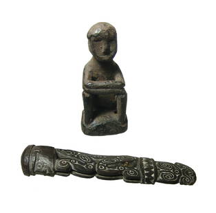
Sold2020A pair of objects from Africa and New GuineaA pair of objects from Africa and New Guinea. Lot includes a lovely carved wood ornamental piece, New Guinea, perhaps a handle, in the form of a seated figure with incised swirled filled with white, tSee Sold Price
Sold20211852 1ed Louisiana History MAP French Colonization1852 1ed Louisiana History MAP French Colonization New Orleans Charles Gayarre Charles Gayarré was a 19th-century American historian who is best remembered for his historical works relating to LouisiSee Sold Price
Sold20211770 Bonne Map of Africa's Guinea Coast to Congo --Title: 1770 Bonne Map of Africa's Guinea Coast to Congo -- Carte de la Haute et de la Basse Guinee Depuis la Riviere de Sierra Leona jusqu'au Cap Negro Cartographer: R Bonne Year / Place: 1770 c., ParSee Sold Price
Sold2022Cortambert french Africa map 1864 engraving hand coloredEugene Cortambert (french, 1805-1881): french Africa map, copper hand colored engraving, from Geographie Universelle de Malte-Brun published in 1864 in Paris by Boulanger & Legrand.24" X 19”.DimSee Sold Price
Sold20191942 Myra Z Barnes Map of French Quarter, New OrleansTitle/Content of Map: 1942 Myra Z Barnes Map of French Quarter, New Orleans -- Le Vieux Carre de la Nouvelle Orleans Date: 1942 ca. Cartographer: Myra Z Barnes Size: 20.5 X 30.8 in. A very attractiveSee Sold Price
Sold2017Barnes: Antique Map of French Quarter, New Orleans 1942Title/Content of Map: 1942 Myra Z Barnes Map of French Quarter, New Orleans -- Le Vieux Carre de la Nouvelle Orleans Date Printed: 1942 Cartographer: Myra Z Barnes Size: 20.5 X 30.8 in. Condition: VerSee Sold Price
20191942 Myra Z Barnes Map of French Quarter, New OrleansTitle/Content of Map: 1942 Myra Z Barnes Map of French Quarter, New Orleans -- Le Vieux Carre de la Nouvelle Orleans Date: 1942 ca. Cartographer: Myra Z Barnes Size: 20.5 X 30.8 in. A very attractiveSee Sold Price
4 days LeftTrillium Antique Prints & Rare BooksPrevost - Map of China, Korea, Japan, Phlippines and Surrounding Islands$50
4 days LeftTrillium Antique Prints & Rare BooksPrevost - Chart of the Atlantic Ocean (Ocean Occidental, including parts of the Americas, Africa,$50
4 days LeftTrillium Antique Prints & Rare BooksPrevost - Pair of Engravings of Chinese Boats or Junks$50
4 days LeftTrillium Antique Prints & Rare BooksPrevost - Pair of Engravings of Indian Coast and Ocean$50
2 days LeftPotter & Potter AuctionsAUDIBERTI, J. Choain. Afrique Equatoriale Francaise. Paris:...$100(1 bid)
May 22Thomaston Place Auction GalleriesHAND COLORED MAP OF PERU & COUNTRY OF THE AMAZONS, 1747, BY EMANUEL BOWEN, FRAMED$250
235 Lots AwayFleischer's Auctions1755 Map Partie de l'Amerique Septentrionale, qui comprend Le Cours de L'Ohio...$200(3 bids)
2 days LeftFreeman's | HindmanJean-Martial Frédou (French, 1711-1795) Portrait of Louis-Joseph-Xavier of France, Duke of$2,500(1 bid)
8 hrs LeftJasper521869 Mitchell Map of Much of Western Europe -- XXXII Prussia the German States Holland & Belgium$30
8 hrs LeftJasper521775-1780 North West Africa with Cape Verde and Canary Islands. By Bonne and Raynal$20
7 hrs LeftJasper521710-1712 BIBLE in GERMAN BIBLIA PENTAPLA 2 VOLUMES w/ MAP antique VELLUM BOUND$550