Sold2022Map of Suriname – 18th Century – With Notation ofNieuwe Kaart van Suriname vertonende de stromen en land-streken van Suriname, Comowini, Cottica, en Marawini. Map of Suriname, hand-colored. Amsterdam: J. Ottens, [early 18th century].A detailed map oSee Sold Price
Sold2017Large and impressive 18th C. map of the Empire of JapanA large and impressive map of the Empire of Japan, by Mattheus Seuter, Amsterdam, 1720-1740. The title: Empire of Japan in 66 Regions. The land areas fully colored, but title cartouche to Benjamin DutSee Sold Price
Sold2023ANTIQUE 18TH C HAND COLORED MAP OF OTTOMAN EMPIREAn antique early 18th-century hand-colored engraved map representing the Ottoman Empire. Published in Nuremberg, Germany, 1720. Titled Imperium Turcicum, technical information in Latin in the lower leSee Sold Price
Sold2016Seutter, Hand Colored Map, Ottoman Empire, 18th C.German, circa 18th century. "Magni Turcarum Dominatoris Imperium per Europam, Asiam, et Africam se extendens Regiones tam proprias quam tributarias et clientelares ut et omnes Beglerbegatus sive PraefSee Sold Price
Sold2017Bellin: Antique Map of Isthmus of Panama, 1754Title: Carte de l'Isthme de Panama et des Provinces de Veragua Terre Ferme et Darien. Detailed mid-18th century map of the Isthmus of Panama Map maker: Jacques Nicolas Bellin Place and Year: Paris, 17See Sold Price
Sold202118th c. Print England and Wales Road Map by Condor"A New Most Accurate & Complete Map of all the Direct and the Principal Cross Roads in England and Wales". Original detailed map shows distances of major roadways across England and Wales, measured inSee Sold Price
Sold202118th C Engraved Map Spain Portugal by Eman BowenNicely detailed map having some hand tinting at borders. Good overall condition with only slight yellowing to paper. Framed nicely. H16" W19" (without mat and frame)See Sold Price
Sold2022A RARE 18TH CENTURY MAHOGANY FRAMED LARGE TRIPLE FOLDING SCREEN DEPICTING A DETAILED MAP OF THE CITYA RARE 18TH CENTURY MAHOGANY FRAMED LARGE TRIPLE FOLDING SCREEN DEPICTING A DETAILED MAP OF THE CITY OF LONDON from a bound volume of the Cities of London and Westminster and Southwark and ten-mile raSee Sold Price
Sold202318th Century English Engraved Map of AfricaBy T. Jefferies circa 1748. Nicely detailed map of Africa and its regions. Some yellowing and slight loss at the edges. H9 3/4" W11 1/4"See Sold Price
Sold20221712 antique MAP of GERMANY POLAND CZECH REPUBLIC 18th CENTURY Regni BohemiaeRegni Bohemiae Ducatus, Silesia, Marchionatus, Moravia, et Lusatiae Highly detailed map of of Silesia, Bohemia, Moravia and Lusatia, current Poland, Czech Republic and Germany regions. With a beautifuSee Sold Price
Sold2020Grp: 5 Maps of Germany Europe and the MediterraneGroup of five 18th century maps. This group includes a hand colored map of Germany by Herman Moll (ca. 1654-1732); one map of the Turkish empire by Tobias Conrad Lotter (1717-1777); one map of the BriSee Sold Price
Sold20231748 1ed History of Germany Frankish Carolingian Holy Roman Empire MAPS Barre 5v1748 1ed History of Germany Frankish Carolingian Holy Roman Empire MAPS Barre 5v Joseph Barre was an 18th-century French theologian who today is much better known for his book History of Germany. ThisSee Sold Price
Sold20211747 1ed JEWS Assyrian Empire Babylon MAPS Phrygians1747 1ed JEWS Assyrian Empire Babylon MAPS Phrygians Hebrews Judaica The “Universal History” is a mid-18th-century history of the world. Written by numerous authors and contributors, this enormousSee Sold Price
Sold20211748 1ed ROME Constantine the Great Trajan MAP1748 1ed ROME Constantine the Great Trajan MAP of Roman Empire Universal History The “Universal History” is a mid-18th-century history of the world. Written by numerous authors and contributors, tSee Sold Price
Sold2021"EMPIRE OF JAPAN", map belonging to the "Atlas"EMPIRE OF JAPAN", map belonging to the "Atlas Universel, dressé sur les meilleures cartes modernes", second half of the 18th century.Illuminated engraving (colour demarcations).Italian edition M.See Sold Price
Sold2021"MAP OF THE PERSEAN EMPIRE", from the "Atlas Universel,"MAP OF THE PERSEAN EMPIRE", from the "Atlas Universel, dressé sur les meilleures cartes modernes", second half of the 18th century.Illuminated engraving (colour demarcations).Italian edition M. ReSee Sold Price
Sold2020Blaeu (Willem) Regnorum Hispani¾18th century. Hand Colored map of Spain, nicely detailed having been hand tinted and in overall well kept condition with some scattered staining and foxing consistent with age. Unframed and has not beSee Sold Price
Sold2021Antique 18th C Imperium Turcicum Hand Colored MapAntique 18th C Imperium Turcicum Hand Colored Map. Circa 1730s. The map shows the Ottoman Empire with an area between Ukraine and Black Sea in the north, Persia / Iran in the east, Arabia and Egypt inSee Sold Price
Sold20181684 10 Rare Book Lot Inca Empire Adventures of Tele1684 10 Rare Book Lot Inca Empire Adventures of Telemachus MAPS Armorial A fine collection of 17th & 18th-century literature including Marmontel’s account of the Incan Empire, Fenelon’s AdventuresSee Sold Price
Sold20211748 1ed Constantinople Byzantine Empire Etruscan1748 1ed Constantinople Byzantine Empire Etruscan Alphabet Hagia Sophia Map The “Universal History” is a mid-18th-century history of the world. Written by numerous authors and contributors, this eSee Sold Price
Sold2021Paolo Petrini (17C.) Hand Colored Naples Italy Map17th to 18th Century panorama map by Paolo Petrini depicting the coastal region of Naples, Italy. Beautifully detailed and colored, with all divisions of the city gorgeous etching artwork throughout.See Sold Price
Sold2023Map of Asia toward the end of the 18th century – PerthesFascinating hand-colored map depicts Asia at the end of the 18th century. The British had established themselves in India and the Chinese Empire was under Manchu control. Also depicts Southeast Asia iSee Sold Price
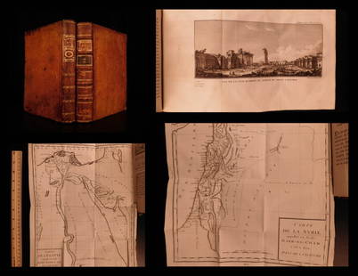
Sold20201787 1st ed Voyages in Syria & EGYPT Africa Illustrated1787 1st ed Voyages in Syria & EGYPT Africa Illustrated MAPS Sphinx 2v Volney “The best expose of Ottoman Empire at the end of the 18th-century!” (Blackmer) Constantin-François Volney, an 18th-ceSee Sold Price
Sold2024ANTIQUE 18th C EMPIRE GAME TABLEGorgeous 18th century Empire style swivel top game table. The peace is flame Mahogany veneer, in excellent condition. Has bead work along bottom edge of table center column has carved design with curlSee Sold Price
May 18Blackstone Valley Auctions & Estates LLCRevolutionary Era War Map of the Attack on Ft. Moultrie.$120(2 bids)
May 18Rich Penn AuctionsDecorative Art, map of South America, late 18th C., framed & matted, Exc cond, 24"H x 20"W overall.$50


![Map of Suriname – 18th Century – With Notation of: Nieuwe Kaart van Suriname vertonende de stromen en land-streken van Suriname, Comowini, Cottica, en Marawini. Map of Suriname, hand-colored. Amsterdam: J. Ottens, [early 18th century].A detailed map o](https://p1.liveauctioneers.com/3506/232707/120467405_1_x.jpg?height=310&quality=70&version=1641394058)