Sold2017Large and impressive 18th C. map of the Empire of JapanA large and impressive map of the Empire of Japan, by Mattheus Seuter, Amsterdam, 1720-1740. The title: Empire of Japan in 66 Regions. The land areas fully colored, but title cartouche to Benjamin DutSee Sold Price
Sold2021"EMPIRE OF JAPAN", map belonging to the "Atlas"EMPIRE OF JAPAN", map belonging to the "Atlas Universel, dressé sur les meilleures cartes modernes", second half of the 18th century.Illuminated engraving (colour demarcations).Italian edition M.See Sold Price
Sold20221749 HUGE Roman Catholic Missal FOLIO Prayers Liturgy1749 HUGE Roman Catholic Missal FOLIO Prayers Liturgy Venice Clement VIII Pius V A large, impressive early 18th-century Roman Missale, published in Venice. This Missal contains prayers, liturgical texSee Sold Price
Sold20181740 Roman Catholic Missal FOLIO Prayers Liturgy Venice1740 Roman Catholic Missal FOLIO Prayers Liturgy Venice Clement VIII Pius V A large, impressive early 18th-century Roman Missale, published in Venice. This Missal contains prayers, liturgical texts, hSee Sold Price
Sold2021Very Impressive Large 18th-19th C. Asian TibetanVery Impressive Large 18th-19th C. Asian Tibetan Warrior's Sword with Layered Damascus Steel Blade ~ Engraved Brass Inlaid Iron Mounts with Superb Silver and Stones Decorations ~ Beautiful and Rare EaSee Sold Price
Sold2023ANTIQUE 18TH C HAND COLORED MAP OF OTTOMAN EMPIREAn antique early 18th-century hand-colored engraved map representing the Ottoman Empire. Published in Nuremberg, Germany, 1720. Titled Imperium Turcicum, technical information in Latin in the lower leSee Sold Price
Sold202218th Century Large French Empire period barometer in18th Century Large French Empire period barometer in finely carved gilt wood. The barometer measures 35"H x 20.5"WSee Sold Price
Sold2016Seutter, Hand Colored Map, Ottoman Empire, 18th C.German, circa 18th century. "Magni Turcarum Dominatoris Imperium per Europam, Asiam, et Africam se extendens Regiones tam proprias quam tributarias et clientelares ut et omnes Beglerbegatus sive PraefSee Sold Price
Sold202118th C Large Handcolored Mercator Map GermanyLarge beautifully handcolored map of Braunswyck and Meydburg after Gerard Mercator circa 1640, this being an 18th century restike.. Printed at Amsterdam. Measures 23 x 19". Fine, reinforced central veSee Sold Price
Sold2023English Maps, Most Th. Kitchin & J. BarberA large unframed collection of 19th or 18th century maps of various English territories, about 50 in total, most by TH. Kitchin and J. Barber.See Sold Price
Sold2017Large Japanese silvered water censerLarge Japanese silvered water censer, 18th/19th c., Japan, bronze censer embellished with speckled silvered patina, flat on three elongated feet, impressed seal on underside, in custom Japanese box, 2See Sold Price
Sold2021An Italian Capriccio Painting with Giovanni PaniniOil on canvas, middle to late 18th century. A large and impressive "Capriccio" or architectural fantasy painting, depicting splendid classical ruins, along with several figures in the foreground, clasSee Sold Price
Sold202418th C. History of United Brethren Mission"History of the Mission of the United Brethren" by G.H. Loskiel, 1794. First Edition. Main source for knowledge on North Americans in the 18th C., with large engraved map. 19in tall x 17-1/4in wide. |See Sold Price
Sold20181747 Middle East Jerusalem Temple Babylon MAP Mesopotam1747 Middle East Jerusalem Temple Babylon MAP Mesopotamia King Salomon Asia ‘A Universal History’ is an impressive 18th-century work of geography and world history published by a variety of EnglisSee Sold Price
Sold2018Bellin: Large Hispaniola MapThe first edition of Bellin's spectacular, large scale map of Hispaniola. Its meticulous topographical and nautical detail makes this one of the major 18th century maps of Hispaniola.; RS2608; Bellin;See Sold Price
Sold2021AN IMPRESSIVE 18TH C. DELFT VESSEL ATTR ALBERTUS KIELLThe large shaped oval form with mask handles either end and large genre scenes in panels on either side raised on scroll feet, marking underside of the base attributed to Albertus Kiell at the 'De WitSee Sold Price
Sold201718th C. Nepalese Wood Block Textile Stamp, Racing HorseCentral Asia, Nepal, ca. late 18th to early 19th century CE. A large, impressive, carved wood stamp decorated with stylized Nepali script, with a horse carrying a tall flame in the upper center of theSee Sold Price
Sold201818th C. Map of Australia w/Strait of Magellan18th c. framed map of Australia w/the Strait of Magellan. Copper engraved map, hand colored, w/ large colored pictorial cartouche, by Bernaidus Joannis Manasterienfis. Visible paper measures approximaSee Sold Price
Sold2022Antique Engraved 18th C Map of Russian LithuaniaLarge copper engraved map of Russian Lithuania. Shows details along the Dniepr and Dwina rivers with the cities of Smolensk, Orsa and Minsk. Decorative cartouche seen on the lower left. Housed under gSee Sold Price
Sold2023Perry, Matthew C. 1856 Large Map. The Coffin Islands, JapanLarge Folio Lithograph Map Published 1856, Washington for "Narrative of the Expedition of an American Squadron to the China Seas and Japan, performed in the years 1852, 1853, and 1854" by Commodore MaSee Sold Price
Sold2020Grp: 5 Maps of Germany Europe and the MediterraneGroup of five 18th century maps. This group includes a hand colored map of Germany by Herman Moll (ca. 1654-1732); one map of the Turkish empire by Tobias Conrad Lotter (1717-1777); one map of the BriSee Sold Price
Sold2021Asian Bronze Tripod Censer w/ 12 Zodiac, 18th C.A large Asian, 18th C,and impressive bronze censer sitting on six small feet, with 12 panels representing the 12 Zodiac signs. Square stamp on center of the base, with four characters. H. 10.5" (26.6See Sold Price
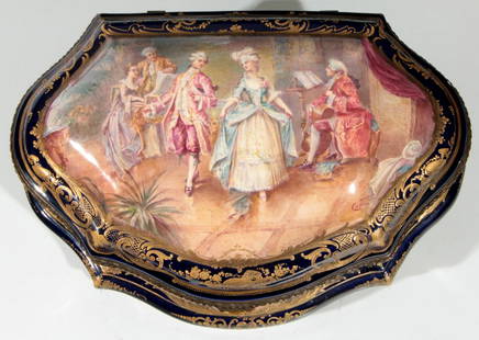
Sold2016A LARGE AND IMPRESSIVE 19TH C. SEVRES CASKETThe cartouche shape dresser box with a high dome cover centered by a hand painted scene of 18th century courtly couples in an interior setting signed Collinet; and bordered within a pronounced gold deSee Sold Price
Sold201618th C. Spanish Colonial Wood Handpainted CrossCentral America, ca. 18th century CE. An exceptionally large and impressive, hand carved wooden Latin cross with remains of green, gold, red, and white, pigment adorning the form. The cross was carvedSee Sold Price
22 hrs LeftJasper521719 Chatelain Map of Russian Empire -- Carte Generale des Etats du Czar Empereur de Moscovie?$320
6 days LeftBidhausGrande Imperiale by Buccellati Italy Silver Flatware Set Service 108 pcs Dinner$88(2 bids)
2 days LeftJasper52Entrée de Norton & Détroit de Bhering. Bering Strait Norton Sound BONNE 1790 map$30(1 bid)
Featured2 days LeftJasper52Entrée de Norton & Détroit de Bhering. Bering Strait Norton Sound BONNE 1788 map$30
2 days LeftJasper52Isles de la Reine Charlotte. Nendo, Santa Cruz, Solomon Islands. BONNE 1790 map$20
2 days LeftJasper52Isles de la Reine Charlotte. Nendo, Santa Cruz, Solomon Islands. BONNE 1788 map$20
2 days LeftJasper52Isles de la Société. Society Islands. Huaheine Raiatea Polynesia. BONNE 1788 map$35
5 days LeftAuction WallstreetMONUMENTAL FLOOR VASE X-Large Antique Asian Dragon Green Glaze Pot Impressive Heavy 37x23 inches$150
May 10New England Auctions - Fred GiampietroPair of York and Lancaster Bas-Relief Carvings$125(2 bids)